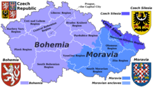
This is a list of the extreme points of Moravia. As there is no current official definition of the borders of Moravia, this list is based on the borders of the historical Moravian land (země Moravská) that existed as an autonomous part of Czechoslovakia until 1928, before having been merged into Moravian-Silesian land (země Moravskoslezská).[1]

Latitude and longitude
edit- North: mountain of Polská hora in Staré Město and Stronie Śląskie on the Czech-Polish borders 50°14′41″N 16°58′35″E / 50.244854°N 16.976267°E
- South: the confluence of Thaya and Morava near Lanžhot 48°37′02″N 16°56′25″E / 48.617147°N 16.940377°E, also the lowest point of Moravia
- West: a confluence of two brooks near Strmilov 49°11′47″N 15°07′59″E / 49.196429°N 15.133183°E
- East: Čudácka Mountain on the Czech-Slovak border, in municipalities Bílá (Czech Republic) and Klokočov (Slovakia) 49°28′06″N 18°32′53″E / 49.468203°N 18.548077°E
Altitude
edit- Maximum: near the summit of Praděd (1,491 m), although the summit itself is in Czech Silesia.[2]
- Minimum: the confluence of Thaya and Morava (also the southernmost point), 148 m.[3]
- Minimum natural below water: bottom of the Hranice Abyss (49°31′55″N 17°45′03″E / 49.532°N 17.750778°E), the deepest flooded pit cave in the world. Its bottom has not been reached yet; the greatest confirmed depth is 473.5 m, but the estimated depth is about 1 km.[4]
See also
editReferences
edit- ^ "Hranice Čech, Moravy a Slezska". hranice.moravy.eu.
- ^ "Vrchol Praděd - Jeseníky-Praděd". www.jeseniky-praded.cz.
- ^ "Významné řeky - Povodí Moravy". www.pmo.cz.
- ^ Klanica, Radek; Kadlec, Jaroslav; Tábořík, Petr; Mrlina, Jan; Valenta, Jan; Kováčiková, Světlana; Hill, Graham J. (April 9, 2020). "Hypogenic Versus Epigenic Origin of Deep Underwater Caves Illustrated by the Hranice Abyss (Czech Republic)—The World's Deepest Freshwater Cave". Journal of Geophysical Research: Earth Surface. 125 (9): e2020JF005663. Bibcode:2020JGRF..12505663K. doi:10.1029/2020JF005663. S2CID 222358747 – via Wiley Online Library.