The Evrotas Valley is an 82 km elongated valley between Taygetus and Parnon which traverses Laconia, Greece. Homer called the valley Kili Lakedemon, while Sparta, Mystras and Gytheio are the main cities within the valley.[1] It is one of the largest valleys in Greece.[2] The valley is predominantly an agricultural region that contains many citrus groves, olive groves, and pasture lands. It is the location of the largest orange production in the Peloponnese and probably in all of Greece. Lakonia, a brand of orange juice, is based in Amykles. The Evrotas Valley records the highest summer mean maximum temperatures in Greece. [3]
| Evrotas Valley | |
|---|---|
 Landscape view of the Evrotas Valley from the Menelaion. | |
 The valley within Laconia | |
| Floor elevation | 0–250 m (0–820 ft) |
| Length | 82 km (51 mi) |
| Width | 17 km (11 mi) |
| Geography | |
| Location | Laconia, Greece |
| Population centers | Sparta, Mystras, Gytheio |
| Coordinates | 36°48′15″N 22°41′45″E / 36.80417°N 22.69583°E |
| Rivers | Evrotas River |
Geography edit
The Evrotas River is the main river traversing the valley. The valley runs until the delta of the river in the Laconian Gulf.[1][4] Modern day Sparta, the capital of the prefecture of Laconia, lies on the eastern foothills of Mount Taygetos. The city has been built upon the site of ancient Sparta, whose Acropolis lies north of the modern city.[5]
The Taygetus Massif is about 100 km (62 mi) long, extending from the center of the Peloponnese to Cape Matapan, its southernmost extremity. It contains the tallest mountain in the Peloponnese, the Profitis Ilias summit, reaching 2,405 m (7,890 ft);[6] this is probably the classical Mount Taléton mentioned by Pausanias.[7] The summit is an ultra-prominent peak. It is prominent above the Isthmus of Corinth, which separating the Peloponnese from mainland Greece, rises only to approximately 60 m (200 ft). Numerous creeks wash down from the mountains and the Evrotas has some of its headwaters in the northern part of the range. The western side of the massif houses the headwaters of the Vyros Gorge, which carries winter snowmelt down the mountain, emptying into the Messenian Gulf in the town of Kardamyli. The Parnon Massif is divided into three parts.[8] The northernmost, which is the highest, runs 30 kilometres (19 miles) from just north of Ano Doliana in North Kynouria, eastern Arcadia, southeast to Platanaki Pass. Platanaki, ancient Glyppia, is on the ancient route from Therapnes to South Kynouria between the peaks of Parnon, 1,935 metres (6,348 feet), and Psaris, 1,836 m (6,024 ft). Altitudes on the north rise from 1,100 m (3,600 ft) to 1,300 m (4,300 ft) increasing toward the peak to 1,600 m (5,200 ft) to 1,800 m (5,900 ft) with a tree line at 1,750 m (5,740 ft). Below it are forests of Black Pine and fir; above it, grasslands. Between the pass and Kounoupia to the south is 22 km (14 mi) of central Parnon, lower in altitude than the northern. The remaining 38 km (24 mi), even lower in altitude but still mountainous, runs from Kounouria to the sea at Epidaurus Limera, which is in Monemvasia. Parnon proper does not extend into the Malea Peninsula. In addition to the range of Parnon, two forelands can also be defined, east and west. Kynouria is located in the east foreland. In the west two lengths can be distinguished: from the northern flank of Parnon to Gkoritsa in Therapnes (on the road to Platanaki Pass), which is 6 km (3.7 mi) to 15 km (9.3 mi), and southward into the Malea Peninsula, 3 km (1.9 mi) to 9 km (5.6 mi) wide.
History edit

The history of the valley is closely linked with ancient Sparta which was built in the west bank of the Evrotas River. Beginning in the 13th century, the political and cultural center of the valley shifted to Mystras, some 4 km to the west. The settlement at ancient Sparta, named Lacedaemonia, continued to exist, although greatly depopulated, until modern times as a town of a few thousand people who lived among the ruins, in the shadow of Mystras.[9] The Palaiologos family (the last Byzantine Greek imperial dynasty) also lived in Mystras. The Despotate of the Morea was captured by the Ottomans under Mehmed II in 1460. In 1834, after the Greek War of Independence, King Otto of Greece decreed the town should be expanded into a city.[10]
Modern Sparta's origins date back to October 20, 1834, when King Otto issued a decree on the construction of the new city. Bavarian city planners, headed by Fr. Stauffert, designed a city of 100,000 inhabitants based on the neo-classical architectural model.Today Sparta maintains its good design, boasting large squares and wide streets lined with trees, while many of the older buildings remain in excellent condition. The city of Sparta is the economic, administrative and cultural center of Lakonia. A key factor in the advancement of the city's development is the operation of two departments of the University of Peloponnese and a department of the Technological Educational Institute.The centrally located main square is dominated by the most imposing neo-classical building in Sparta, the City Hall. Built in 1909, City Hall bears the signature of the Greek architect G. Katsaros.[11] During the monarchy (which was abolished by referendum in 1973), the title of Duke of Sparta was used for the Greek crown prince, the διάδοχος (diádokhos).
Climate edit

The Evrotas Valley enjoys a sunny and warm Mediterranean climate (Köppen: Csa). The interior of the valley records the highest summer mean maximum temperatures in Greece and is comparable to inland areas of western Andalusia in terms of summer average highs. This is due to the interior's geographical location between Taygetus and Parnon mountains, completely cut out from the sea on all directions, some 30 km away from the shores. As the meltemi winds sweep Greece during the summer, both mountains provide a constant hot foehn winds effect which strongly affects the interior of the valley.[12]
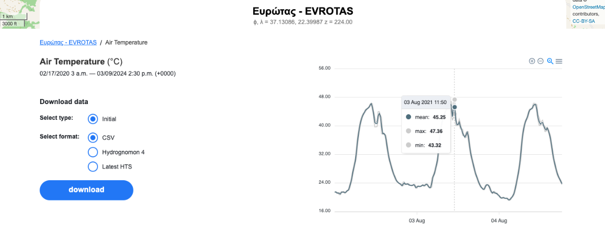
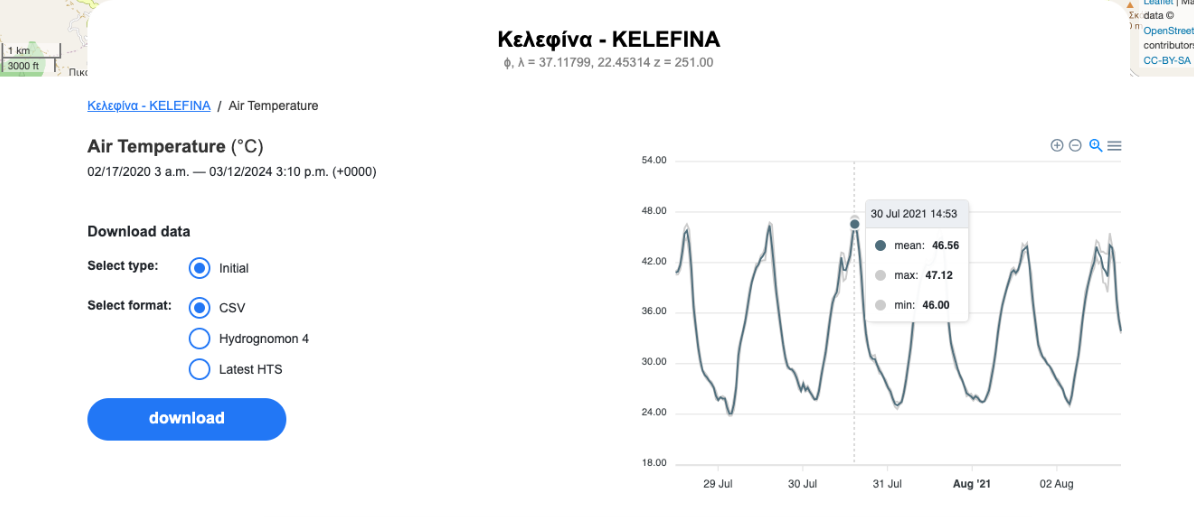
During July 2023 the Hydro Meteorological station of the National Observatory of Athens in Evrotas registered a record mean max temperature of 42.3°C. [13] On August 3, 2021 the Evrotas station recorded 47.4°C. [14] [15] On average this station records 43 days annually with temperatures over 40.0°C. [16] On July 30, 2021 the Kelefina Hydro Meteorological station of the National Observatory of Athens recorded 47.1°C.[17] [18] [19] [20] [21]
In July 2023 the World Meteorological Organization station in Gytheio[22] registered 46.4°C which is the highest temperature ever recorded in the National Observatory of Athens fan aspirated stations network.[23]
| Climate data for Evrotas (National Observatory of Athens) 224 m a.s.l. | |||||||||||||
|---|---|---|---|---|---|---|---|---|---|---|---|---|---|
| Month | Jan | Feb | Mar | Apr | May | Jun | Jul | Aug | Sep | Oct | Nov | Dec | Year |
| Record high °C (°F) | 25.4 (77.7) |
28.7 (83.7) |
32.5 (90.5) |
36.5 (97.7) |
42.8 (109.0) |
44.9 (112.8) |
47.0 (116.6) |
47.4 (117.3) |
42.1 (107.8) |
39.6 (103.3) |
34.5 (94.1) |
27.6 (81.7) |
47.4 (117.3) |
| Mean maximum °C (°F) | 24.7 (76.5) |
26.5 (79.7) |
28.1 (82.6) |
32.7 (90.9) |
39.5 (103.1) |
42.3 (108.1) |
45.3 (113.5) |
45.0 (113.0) |
40.9 (105.6) |
37.5 (99.5) |
32.4 (90.3) |
25.2 (77.4) |
45.3 (113.5) |
| Mean daily maximum °C (°F) | 17.4 (63.3) |
19.2 (66.6) |
19.9 (67.8) |
25.4 (77.7) |
32.0 (89.6) |
36.1 (97.0) |
40.5 (104.9) |
39.8 (103.6) |
35.4 (95.7) |
30.2 (86.4) |
24.0 (75.2) |
19.1 (66.4) |
28.3 (82.9) |
| Daily mean °C (°F) | 10.1 (50.2) |
11.1 (52.0) |
11.8 (53.2) |
16.2 (61.2) |
21.4 (70.5) |
25.5 (77.9) |
29.2 (84.6) |
29.0 (84.2) |
25.3 (77.5) |
20.6 (69.1) |
15.9 (60.6) |
12.1 (53.8) |
19.0 (66.2) |
| Mean daily minimum °C (°F) | 2.8 (37.0) |
2.9 (37.2) |
3.7 (38.7) |
6.9 (44.4) |
10.9 (51.6) |
15.0 (59.0) |
17.9 (64.2) |
18.1 (64.6) |
15.1 (59.2) |
11.1 (52.0) |
7.7 (45.9) |
5.1 (41.2) |
9.8 (49.6) |
| Mean minimum °C (°F) | −3.9 (25.0) |
−3.4 (25.9) |
−1.2 (29.8) |
1.7 (35.1) |
6.9 (44.4) |
10.9 (51.6) |
14.9 (58.8) |
15.5 (59.9) |
10.8 (51.4) |
7.5 (45.5) |
1.9 (35.4) |
−0.1 (31.8) |
−3.9 (25.0) |
| Record low °C (°F) | −6.5 (20.3) |
−5.1 (22.8) |
−2.5 (27.5) |
−1.0 (30.2) |
5.8 (42.4) |
9.3 (48.7) |
12.7 (54.9) |
15.0 (59.0) |
8.0 (46.4) |
5.8 (42.4) |
−0.5 (31.1) |
−2.6 (27.3) |
−6.5 (20.3) |
| Average rainfall mm (inches) | 101.2 (3.98) |
38.2 (1.50) |
56.0 (2.20) |
33.5 (1.32) |
21.3 (0.84) |
43.6 (1.72) |
11.2 (0.44) |
25.1 (0.99) |
39.3 (1.55) |
64.6 (2.54) |
98.9 (3.89) |
96.3 (3.79) |
629.2 (24.76) |
| Source 1: Hydro Meteorological station of Evrotas, National Observatory of Athens (Mar 2020 - Feb 2024) [24] | |||||||||||||
| Source 2: Precipitation from Sparta N.O.A station [25] | |||||||||||||
| Climate data for Sparta (2009–2024) | |||||||||||||
|---|---|---|---|---|---|---|---|---|---|---|---|---|---|
| Month | Jan | Feb | Mar | Apr | May | Jun | Jul | Aug | Sep | Oct | Nov | Dec | Year |
| Record high °C (°F) | 23.5 (74.3) |
26.4 (79.5) |
27.2 (81.0) |
34.1 (93.4) |
40.7 (105.3) |
44.4 (111.9) |
44.2 (111.6) |
45.7 (114.3) |
40.3 (104.5) |
36.4 (97.5) |
30.8 (87.4) |
23.5 (74.3) |
45.7 (114.3) |
| Mean daily maximum °C (°F) | 14.4 (57.9) |
16.1 (61.0) |
18.4 (65.1) |
22.8 (73.0) |
27.8 (82.0) |
32.5 (90.5) |
36.0 (96.8) |
35.9 (96.6) |
31.3 (88.3) |
25.3 (77.5) |
20.2 (68.4) |
16.1 (61.0) |
24.7 (76.5) |
| Daily mean °C (°F) | 8.8 (47.8) |
10.0 (50.0) |
12.0 (53.6) |
15.4 (59.7) |
20.0 (68.0) |
24.6 (76.3) |
27.7 (81.9) |
27.7 (81.9) |
23.8 (74.8) |
18.5 (65.3) |
14.1 (57.4) |
10.2 (50.4) |
17.7 (63.9) |
| Mean daily minimum °C (°F) | 3.1 (37.6) |
4.0 (39.2) |
5.6 (42.1) |
8.0 (46.4) |
12.2 (54.0) |
16.7 (62.1) |
19.5 (67.1) |
19.6 (67.3) |
16.4 (61.5) |
11.8 (53.2) |
7.9 (46.2) |
4.4 (39.9) |
10.8 (51.4) |
| Record low °C (°F) | −5.3 (22.5) |
−4.2 (24.4) |
−4.6 (23.7) |
−0.7 (30.7) |
6.2 (43.2) |
9.4 (48.9) |
14.2 (57.6) |
13.1 (55.6) |
9.1 (48.4) |
1.5 (34.7) |
−1.7 (28.9) |
−5.2 (22.6) |
−5.3 (22.5) |
| Average rainfall mm (inches) | 122.6 (4.83) |
82.3 (3.24) |
62.4 (2.46) |
33.1 (1.30) |
24.8 (0.98) |
35.3 (1.39) |
11.9 (0.47) |
19.0 (0.75) |
52.2 (2.06) |
61.5 (2.42) |
88.1 (3.47) |
92.0 (3.62) |
685.2 (26.99) |
| Source: National Observatory of Athens (Feb 2009 - Feb 2024),[26][27] Sparta N.O.A station,[28] World Meteorological Organization[29] | |||||||||||||
Highest temperatures recorded edit
Below a list of the highest temperatures ever recorded in the Evrotas Valley.
| Temperature | Location | Date Recorded |
|---|---|---|
| 47.4 °C (117.3 °F)[30] [31] | Evrotas | August 3, 2021 |
| 47.1 °C (116.8 °F) [32] [33] | Kelefina | July 30, 2021 |
| 47.0 °C (116.6 °F)[34] | Evrotas | July 22, 2023 |
| 46.4 °C (115.5 °F) [35] | Gytheio | July 23, 2023 |
| 46.3 °C (115.3 °F)[36] | Evrotas | August 2, 2021 |
| 46.3 °C (115.3 °F)[37] | Evrotas | August 4, 2021 |
| 46.2 °C (115.2 °F)[38] | Evrotas | July 23, 2023 |
| 46.0 °C (114.8 °F) [39] | Sparta | August 24, 1924 |
| 45.9 °C (114.6 °F)[40] | Evrotas | July 26, 2023 |
Ecosystem edit
The past few years the river has been littered with garbage while problems with animal overeating is affecting the valley. In January 2011 thousands of fish were found dead at the banks of the Evrotas River.[41]
References edit
- ^ a b Zogaris, Stamatis. "Evrotas Valley, River of the South". Retrieved 27 November 2023.
- ^ "The plains and valleys of Greece". Retrieved 27 November 2023.
- ^ "Meteo.gr - Προγνώσεις καιρού για όλη την Ελλάδα".
- ^ "The Maritime and Riverine Networks of the Eurotas River Valley in Lakonia". Retrieved 27 November 2023.
- ^ "Αρχαία Σπάρτη". Αρχαιολογία Online (in Greek). Retrieved 2019-07-17.
- ^ "Other map sources give the elevation as 2407m, but GPS readings seem to confirm the 2404m value on the Greek topographic maps." "Europe Ultra-Prominences" - Footnote#13. Peaklist.org. Retrieved 2014-05-25.
- ^ Waterhouse, Helen; Simpson, R. Hope (1960). "Prehistoric Laconia: Part I". The Annual of the British School at Athens. 55: 67–107. doi:10.1017/s0068245400013290. JSTOR 30104479. S2CID 210050738.
- ^ Unless otherwise cited this section relies heavily on Cartledge, Paul (2002). Sparta and Lakonia: A regional history 1300–362 BC (PDF). Taylor & Francis e-Library. London and New York: Routledge. pp. 13–14. Archived from the original (PDF) on 2012-03-25. Retrieved 2011-09-01.
- ^ Encyclopædia Britannica Eleventh Edition
- ^ "Αρχαία Σπάρτη". Αρχαιολογία Online (in Greek). Retrieved 2019-07-17.
- ^ "Modern day Sparta". Archived from the original on 2016-10-04. Retrieved 2014-09-06.
- ^ "Sparta: Greece's heat superpower". Retrieved 27 November 2023.
- ^ "Evrotas Air Temperature". National Observatory of Athens. Retrieved 12 March 2024.
- ^ "Evrotas Air Temperature". National Observatory of Athens. Retrieved 12 March 2024.
- ^ "47.4C Evrotas NOA". Retrieved 12 March 2024.
- ^ "Evrotas Air Temperature". National Observatory of Athens. Retrieved 12 March 2024.
- ^ "Kelefina Air Temperature". National Observatory of Athens. Retrieved 12 March 2024.
- ^ "47.1C Kelefina NOA". Retrieved 12 March 2024.
- ^ "Impressive summer data from the Evrotas Valley". Laconia TV. Archived from the original on 18 March 2024. Retrieved 19 March 2024.
{{cite web}}: CS1 maint: bot: original URL status unknown (link) - ^ "Evrotas Valley: The Valley of fire with temperatures reaching 48C". Notos Press. 19 March 2024. Retrieved 19 March 2024.
- ^ "High temperatures in the Evrotas Valley". Lakonikos press. Retrieved 22 March 2024.
- ^ "World Meteorological Organization". Retrieved 27 November 2023.
- ^ "Gytheio record". Retrieved 27 November 2023.
- ^ "Evrotas". National Observatory of Athens. Retrieved 12 March 2024.
- ^ "N.O.A Monthly Bulletins".
- ^ "Climate" (in Greek). National Observatory of Athens. Archived from the original on 27 September 2022.
- ^ "N.O.A Monthly Bulletins".
- ^ "Latest Conditions in Sparta".
- ^ "World Meteorological Organization". Retrieved 14 July 2023.
- ^ "Evrotas Air Temperature". National Observatory of Athens. Retrieved 12 March 2024.
- ^ "47.4C Evrotas NOA". Retrieved 12 March 2024.
- ^ "Kelefina Air Temperature". National Observatory of Athens. Retrieved 12 March 2024.
- ^ "47.1C Kelefina NOA". Retrieved 12 March 2024.
- ^ "Evrotas Air Temperature". National Observatory of Athens. Retrieved 12 March 2024.
- ^ "Gytheio record". Retrieved 23 July 2023.
- ^ "Evrotas Air Temperature". National Observatory of Athens. Retrieved 12 March 2024.
- ^ "Evrotas Air Temperature". National Observatory of Athens. Retrieved 12 March 2024.
- ^ "Evrotas Air Temperature". National Observatory of Athens. Retrieved 12 March 2024.
- ^ "Heatwaves in Greece". 5 May 2020. Archived from the original on 2021-07-28. Retrieved 25 March 2024.
- ^ "Evrotas Air Temperature". National Observatory of Athens. Retrieved 12 March 2024.
- ^ "Dead fish in the Evrotas Valley". 21 January 2011. Retrieved 27 November 2023.