| Draft article not currently submitted for review.
This is a draft Articles for creation (AfC) submission. It is not currently pending review. While there are no deadlines, abandoned drafts may be deleted after six months. To edit the draft click on the "Edit" tab at the top of the window. To be accepted, a draft should:
It is strongly discouraged to write about yourself, your business or employer. If you do so, you must declare it. Where to get help
How to improve a draft
You can also browse Wikipedia:Featured articles and Wikipedia:Good articles to find examples of Wikipedia's best writing on topics similar to your proposed article. Improving your odds of a speedy review To improve your odds of a faster review, tag your draft with relevant WikiProject tags using the button below. This will let reviewers know a new draft has been submitted in their area of interest. For instance, if you wrote about a female astronomer, you would want to add the Biography, Astronomy, and Women scientists tags. Editor resources
Last edited by LukasSimeone (talk | contribs) 3 days ago. (Update) |
Yinainir
ينينير | |
|---|---|
 Yinainir. Small farming village, in the Hajar Mountains, very close to the border with Oman, and Wadi Arus. | |
 Yinainir Location of Yinainir within the UAE | |
| Coordinates: 25°58′04″N 56°10′04″E / 25.96778°N 56.16778°E | |
| Country | |
| Emirate | |
| Area | |
| • Total | 0.60 km2 (0.23 sq mi) |
| Elevation | 880 m (2,887 ft) |
| Population (2023) | |
| • Total | 3 |
| Time zone | UTC+04:00 |
Yinainir (Arabic: ينينير, romanized: Yinēnīr)[1][2] is a small village, located in the northeast of United Arab Emirates (UAE), in the Hajar Mountains, Emirate of Ras Al Khaimah, inaccessible by road.
An extensive area with numerous terraces has been preserved from the old village to this day, supported by dry stone walls, without mortar, which allow water and earth to be retained, intended for pastures and other agricultural uses; corrals; ruins of houses, huts and stone cabins; and even an old cemetery.
Geography
editYinainir is located to the west and almost at the foot of the great cliff that geographically delimits, in that area, the border between United Arab Emirates and Oman, crowned by the peaks of the Jabal Sal (1,575 m) [3] and of the Jabal Yabānah (1,480 m).[4]
To the east of the settlement is the headwaters and the main alluvial fan of the Wadi Arus,[5] a major tributary of the Wadi Shah, and approximately 2 km northwest of the small village of Musaibat.[6]
Population
editIn general, the area of Yinainir was historically populated by the Bani Shatair (Arabic: بني شطير) tribe, one of two sections chiefs of the semi-nomadic tribe Shihuh, which occupied, among other territories, the tribal area of Bani Bakhit.[7]
On the other hand, Edward F. Henderson, in his report "Tribes of Trucial States coast",[8] expressly points out Yinainir as an important reference village for another major Shihuh section: the Bani Hadiyah (Arabic: بني هدية), Bani Idaid tribal area.[9]
Toponymy
editAlternative Names: Yinainir, Yinēnīr, ينينير
The name of this village was recorded in the documentation and maps produced between 1950 and 1960 by the British Arabist, cartographer, military officer and diplomat Julian F. Walker, during the work carried out for the establishment of borders between the then called Trucial States, later completed by the Ministry of Defense of the United Kingdom, on 1:100,000 scale maps published in 1971.[10]
It also appears, with the spelling Yinēnīr, in the National Atlas of the United Arab Emirates.[1]
Gallery
edit-
 Wadi Arus. View of the ravines that flow from the border cliff between Oman and UAE, towards the ancient town of Yinainir.
 -
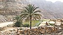 Yinainir - Wadi Arus - Palm trees and terraces in its middle course.
 -
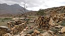
 Yinainir - Terraces and stone buildings.
 -
 Yinainir - Stone constructions - Semi abandoned. In the background, the Jabal Yabanah with its two peaks


References
edit- ^ a b Jāmiʻat al-Imārāt al-ʻArabīyah al-Muttaḥidah. Geoprojects (U.K.) Ltd., The National atlas of the United Arab Emirates, Al Ain : United Arab Emirates University - 1993
- ^ Mindat.org - Yinainir
- ^ Mindat.org - Jabal Sāl
- ^ Geonames - Jabal Yabānah
- ^ Mindat.org - Wādī 'Arūs
- ^ GeoNames - Musaibat
- ^ Getamap.net - Banī Bakhīt / Ra's al Khaymah
- ^ FO 371/132894 - 1958 - Tribes of Trucial States coast - E F Henderson's notes on the Trucial Coast tribes with amendments and further notes by M S Buckmaster and J F Walker - The National Archives, London, England <https://www.agda.ae/en/catalogue/tna/fo/371/132894/n/38>
- ^ Mindat.org - Banī ‘Udayd
- ^ Map of Trucial States, Muscat and Oman - Rams - Scale 1:100 000 - Published by D Survey, Ministry of Defence, United Kingdom (1971) - Edition 3-GSGS - The National Archives, London, England <https://www.agda.ae/en/catalogue/tna/fco/18/1785>
Maps and bibliography
edit- FCO 18/1932 - 1958- Sketch map drawn by Julian Walker for boundary delimitation: Ras Al Khaimah - The National Archives, London, England
- FCO 18/1920 - 1962 - Boundaries of the Northern Trucial States: prepared and drawn from sketch maps and information supplied by Julian Walker; preliminary edition - The National Archives, London, England
- FCO 8/586 - 1967-1968 - Boundary between East Aden Protectorate and Muscat and Oman - The National Archives, London, England
- FCO 18/1863 - 1971 - Trucial States, Muscat and Oman - Rams - Map. Scale 1:100 000 - Published by D Survey, Ministry of Defence, United Kingdom (1971) - Edition 3-GSGS - The National Archives, London, England
- Heard-Bey, Frauke (2005). From Trucial States to United Arab Emirates : a society in transition. London: Motivate. ISBN 1860631673. OCLC 64689681.
| Cities |  | |
|---|---|---|
| Settlements | ||
| Mountains | ||
Category:Yinainir Category:United Arab Emirates geography stubs Category:Populated places in the Emirate of Ras Al Khaimah Category:Villages in the United Arab Emirates
External links
edit![]() Media related to Yinainir at Wikimedia Commons
Media related to Yinainir at Wikimedia Commons