The Kitab-ı Bahriye (كتاب بحرية), or Book of the Sea, is a navigational guide written by Ottoman cartographer, corsair, and captain Piri Reis.[1][2] After the death of his uncle Kemal Reis,[3] Piri Reis compiled navigational charts and notes into the most detailed portolan atlas in existence.[4][5] There are two versions of the book.[2] The first version was composed between 1511 and 1521.[6][7] Both versions begin with a preface and were dedicated to the sultan Suleiman the Magnificent.[8]
| Kitâb-ı Bahriye كتاب بحرية | |
|---|---|
| Topkapı Palace | |
,_1590_ca._(bnf)_01.jpg) A copy open to the page on Corsica | |
| Date | 1521, 1526 |
| Place of origin | Gallipoli, Ottoman Empire |
| Language(s) | Ottoman Turkish |
| Author(s) | Piri Reis |
| Dedicated to | Suleiman the Magnificent |
| Material | Paper |
The second version—completed by 1526—includes a longer introduction written in verse.[2] It offers information on storms, winds, navigating with a compass, navigating by the stars, reading portolan charts, and the oceans.[8] It includes information on recent Portuguese and Spanish voyages including the voyages of Christopher Columbus to the Americas and Vasco da Gama's discovery of a sea route to India.[2] It offers the first detailed Ottoman description of the Indian Ocean, with special attention given to Hormuz.[9][2]
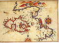
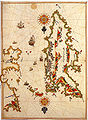
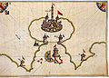
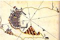
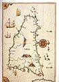
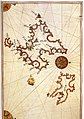
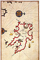
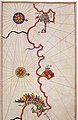
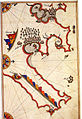
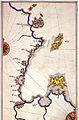
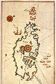
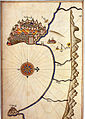
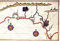
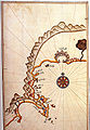
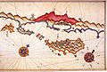
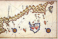
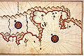
The main part of both versions is a nautical atlas to the Mediterranean Sea. Separate chapters cover different locations with corresponding portolan charts.[8] There are 130 chapters in the first version and 210 in the second.[8] Piri Reis says he composed an atlas with separate maps and charts because the details in any single map are limited by the space available.[8] The chapters start at the Dardanelles and move counter-clockwise around the Mediterranean.[10] The Kitab-ı Bahriye combines information from a range of sources and Piri Reis' personal experience. The coast of North Africa relies little on outside sources.[11] The book is also one of the few primary sources of information on Piri Reis.[12][13] Its maps have compass roses indicating North for each page.[14][5] Scale is indicated only in the textual descriptions, not with scale bars.[5] Standard portolan symbols indicate hazards, like dots for shallow water and crosses for rocks.[14] Written when Ottoman sailors relied on oar-driven galleys and galiots, the Kitab-ı Bahriye reflects their needs and capabilities. It gives information on coastal waters, safe harbors, hazards, and sources of fresh water.[15]
The known surviving manuscripts are all copies created beginning in the later 1500s.[16] The book achieved fame only after the death of its author.[17] At least some portion of the book has been translated into English, modern Turkish, Greek, French, German, and Italian.[18]
History
edit
From an early age, Piri Reis sailed with his uncle Kemal Reis, first as a corsair, and later in the Ottoman Navy.[19][20] After his uncle died in 1511, Piri Reis returned to his hometown, Gallipoli. He created a world map in 1513 and likely began compiling the notes and charts that would form the basis of the Kitab-ı Bahriye.[3] Piri Reis rejoined the Ottoman Navy for the Ottoman–Mamluk War (1516–1517) and presented the world map to Selim I in 1517.[21][22] In the following decade, Piri Reis completed two versions of the Kitab-ı Bahriye and a second world map.[3]
Both versions of the Kitab-ı Bahriye begin with a dedication to Suleiman the Magnificent. When Suleiman began his reign in 1520, Ottoman craftsmen offered exemplars of their work as gifts.[8][23] The Kitab-ı Bahriye's preface reads, "The reason for compiling this book is that a number of master craftsmen have now brought forward offerings from their various trades to the auspicious threshold and felicitous gate of His Majesty the World-protecting Emperor, so as to gain high status in society and attain name and renown through the matchless favor of that well-favored sovereign."[23] There's no evidence that the first version received a positive or enthusiastic response from the sultan.[23]
The second version was drafted after Piri Reis took the Ottoman Grand Vizier Pargalı İbrahim Pasha to Egypt.[23][24] When putting down Hain Ahmed Pasha's rebellion in Egypt, Ibrahim rode aboard the navy's flagship, commanded by Piri Reis.[21] During the trip, they took shelter at Rhodes to wait out a storm. They discussed the original Kitab-ı Bahriye and other charts on the ship.[13] Ibrahim commissioned Piri Reis to create an expanded version of the Kitab-ı Bahriye.[2] He did so and presented it to the Sultan by 1526.[2]
Whenever I fell into distress at sea, I always consulted a book. The [sailing] directions that I had written down in [this] book of mine amply demonstrated the excellence of my expertise. His excellency the great Pasha saw how my book was being put to use all the time. He understood that there was something valuable there, and he [expressed] a wish to examine it. When it was brought to him he looked at its every detail and [realized] how I was plotting the course with it. He thus grasped its gist…; he knew that there was accuracy, mastery in the art of navigation [contained in my book]… [and] he showed esteem for this slave of his as a result. … He said, ‘You are a very able man, and there is much excellence in your character. The entire configuration of the sea has become known [to you]: none of its spots are hidden from you. I wish that you make all of it manifest, and that you be remembered by it until doomsday. You should polish up this book well, all of it, so that it may be much used… Moreover, this book is very appealing, fit for being preserved in libraries. Polish it up and bring it without fail, so that we may present it to the sovereign of the world.’
The details in a portolan chart were limited by the space available on the map. Piri Reis says this is why he used separate maps and prose descriptions.[8] The books combine information from a range of sources and his personal experience. The areas that most reflect Piri Reis' direct experiences are the coasts of North Africa.[11] Tunisia is likely drawn from personal observations. Djerba, in particular, includes greater detail than the highly-regarded maps Giacomo Gastaldi composed in sixteenth-century Italy.[26]
There is no evidence that the Kitab-ı Bahriye circulated outside of the royal palace prior to 1550.[17] From 1560 to 1600, many copies were created and spread. At least 15 surviving manuscripts are from this period.[17] The total number of copies may have reached into the hundreds.[17] There was a greater demand for Turkish geographical texts in the late sixteenth century than during the life of Piri Reis.[17]
Contents
edit
The Kitab-ı Bahriye is a portolan atlas that offered the most detailed navigational guide to the Mediterranean Sea for its time.[3][28] Like portolan maps, the Kitab-ı Bahriye uses compass roses for navigation, rather than lines of longitude and latitude.[14] Arrows on each chart indicate North. There are no visual scale bars; distances are explained in the prose.[5] The maps use standard symbols like dots for shallow water and crosses for rocks.[14] Compared to inscriptions on contemporary maps, the book is highly personal and anecdotal.[14]
The isolario genre was a major influence on Piri Reis. Isolarios were books with written descriptions and maps. Typically written for amusement, they contained minimal guidance on navigation and focused on history and topography. An isolario—like Benedetto Bordone's The Book of Islands compiled in Venice around the same time as the Kitab-ı Bahriye—was divided into chapters with maps of the locations described.[29] Historian Thomas Day Goodrich has argued that the Kitab-ı Bahriye introduced the technique of referring to the maps from within the book's text. Prose portions of the Kitab-ı Bahriye refer the reader to specific maps for details or a better understanding of the geography.[5]
The Kitab-ı Bahriye's charts begin at the Dardanelles strait and move counter-clockwise around the Mediterranean.[10] Like other Ottoman atlases, the Kitab-ı Bahriye focuses more on warfare and raiding than trade routes.[9] Piri Reis sailed, raided, and fought as a ghazi and corsair, so he wrote from this perspective.[9]
The Kitab-ı Bahriye is a practical navigation guide, and the sixteenth-century Ottoman fleet relied mainly on galleys and galiots. These ships could be propelled by sails or oars.[30] The Kitab-ı Bahriye reflects their capabilities and is written for a captain making a series of short coastal voyages.[31] The length of galleys combined with their low freeboard made them quick but susceptible to storms and high winds.[32] The Kitab-ı Bahriye gives information on coastal waters, hazards, and safe harbors.[31] The most commonly depicted watercraft is the galley, but the Kitab-ı Bahriye also frequently mentions sandals, a type of small rowing boat. A sandal could be carried or pulled by a galley and rowed to shore for scouting or gathering fresh water.[29] Galleys needed to frequently stop for supplies, and the Kitab-ı Bahriye notes where fresh water can be found.[32] For example, in the section covering the Galite Islands, the Kitab-ı Bahriye notes the dangers posed by southern winds, the availability of wild goats, and the quality of the fresh water which Piri Reis compares in flavor to rose water.[33]
Ottoman naval warfare during the period was often amphibious, involving the transport of troops from land under Ottoman control.[34] The Kitab-ı Bahriye gives details about land-based fortifications, including their current condition.[34] A 2020 analysis of two copies found each depicted over 100 fortified towns, over 800 fortresses, about 390 towers, just over 100 ruins, 148 ports, and about 200 fresh-water springs.[35] The detailed section on Venice explains how the city—built on piles in a lagoon—lacked drinking water and had to ship it in from rivers on the mainland.[36]
The Kitab-ı Bahriye is one of the few sources of biographical information on Piri Reis.[37] Some copies have updated maps and depict additional areas not covered in the text like the Black Sea.[38][39] The book includes first-hand information from Piri Reis' own sailing and his early experiences with his uncle in the Western Mediterranean.[40] It contains autobiographic information up to 1526, the year it was presented to the sultan.[13]
Versions
edit

Piri Reis produced two versions of the book, an initial 1521 version with 130 chapters and a second 1526 version with 210 chapters.[8] Many copies of both versions have been preserved, but not the originals.[8] Over 40 manuscripts—produced from the late 1500s to the 1700s—survive today, 26 in Istanbul alone. The number of maps varies, and a few have no maps at all. Three copies have no text and only maps.[27] The number of charts in surviving manuscripts varies as some contain additional charts added by copyists.[8] Some later copies have updated maps and depict additional places like the Black Sea which is not covered in the text.[38][39] Across the surviving manuscripts, there are over 5700 total maps.[27] According to historian Thomas Day Goodrich, there are more hand-drawn manuscript maps of Piri Reis' work than any other cartographer.[5]
The original version is less artistic but more practical; it saw use by later sailors. The second version includes more detailed maps decorated with Ottoman miniatures.[41] The first version begins with a standard Ottoman introduction offering praise to Allah and Muhammad along with an explanation of the book's purpose.[42] The 1526 version includes a longer introduction and an added epilogue, both written in verse.[8] The longer preface adds details about recent Portuguese and Spanish voyages around Africa and to the Americas, as well as the first detailed Ottoman description of the Indian Ocean. It gives special attention to Hormuz, a strategically valuable port at the entrance to the Persian Gulf.[9][2] The description of the Americas includes fantastical hearsay; it describes natives with massive flat faces and the width of an entire hand between their eyes. It also includes Piri Reis' own experiences taking exotic American items from European sailors.[43] The epilogue covers how the second version resulted from discussions with Ibrahim Pasha.[8]
Most extant manuscripts are luxury items, but a few show signs of use at sea.[44] One copy at Kiel University has water stains and marginal notes written by an anonymous mariner.[5] The copies of the more practical 1521 version identify the copyists and the place of production. The copies of the more artistic 1526 version leave out the identity of the copyists.[41] Most copies of the second version were likely created by the miniaturists working in Istanbul during the 1500s and 1600s.[39]
Study
editAt least some portion of the Kitab-ı Bahriye has been translated into German, French, English, Italian, and Greek.[45] Scholarly analysis of the book began after the French translation by Denis Dominique Cardonne in 1765.[46] A facsimile of the second version was published in 1935 by the Turkish Historical Society with a complete historical introduction.[44] It was based on the Ayasofya manuscript at the Süleymaniye Library in Istanbul.[47] In 1910, Sachau published a study of the Sicily section.[46] Orientalist Paul E. Kahle began to translate and study a copy of the first version in the 1920s.[46] Uriel Heyd found in a 1956 study that across the many copies "place-names, in particular, were distorted by copyists". Later studies by Jean-Louis Bacqué-Grammont, Dimitris Loupis, and Svat Soucek have sought to create a standard reading of the placenames across the maps.[46]
The Turkish Ministry of Culture and Tourism published a 4-volume edition of the book in 1988.[46][7] It includes a full-color, photographic facsimile of the manuscript, a transliteration from the original Arabic script into the Turkish alphabet, a translation into modern Turkish, and a translation into English.[7]
Manuscripts
editCopies of the Kitab-ı Bahriye are found in libraries in Istanbul and in some of the major libraries in Europe, besides one copy known to be held privately in the USA (Walters Art Museum).[7][48][27]
| Place | Institution | Manuscript | Maps | Date | Copyist |
|---|---|---|---|---|---|
| Berlin, from Tübingen | Berlin State Library, from University of Tübingen | Ms. Or. Fol. 4133 | —
|
1645 | —
|
| Bologna | Bologna University Library | Ms. Marsili 3612 | 105 | —
|
—
|
| Bologna | Bologna University Library | Ms. 3613 | 125 | 1569 | —
|
| Dresden | Saxon State and University Library Dresden | Ms. Eb 389 | 119 | 1554 | —
|
| Istanbul | Istanbul Naval Museum | No. 987 | 88 | —
|
Mehmed Seyyid |
| Istanbul | Istanbul Naval Museum | No. 990 | 134 | —
|
—
|
| Istanbul | Köprülü Library, Fazıl Ahmed Paşa | Ms. 172 | 123 | 1657 | —
|
| Istanbul | Millet Yazma Eser Kütüphanesi | Coğrafya 1 | 129 | —
|
—
|
| Istanbul | Nuruosmaniye Library | Ms. 2990 | 126 | 1654 | Ahmed ibn Mustafa |
| Istanbul | Nuruosmaniye Library | Ms. 2997 | 124 | 1628 | Mustafa ibn Muhammad Cündi |
| Istanbul | Süleymaniye Library | Ms. Aya Sofya 2605 | 133 | 1721 | Muh. b. Kalgan and Muh. Sadık |
| Istanbul | Süleymaniye Library | Âşır Efendi 227 | 92 | —
|
—
|
| Istanbul | Süleymaniye Library | Ms. Aya Sofya 3161 | 125 | —
|
—
|
| Istanbul | Süleymaniye Library | Hamidiye 945 | 42 | 1554–1555 | Ahmed ibn 'All ibn Mehmed |
| Istanbul | Süleymaniye Library | Hüsrev Paşa 272 | 127 | 1570 | —
|
| Istanbul | Süleymaniye Library | Yeni Cami 790 | 128 | 1551 | Muhyiddin |
| Istanbul | Topkapı Palace | Ms. Baghdad 337 | 134 | 1574 | —
|
| Istanbul | Istanbul University Library | Türkçe 123/2 | 119 | —
|
—
|
| Kiel | Kiel University Library | Ms. Cod. Or. 34 | 51 | 1553–1600 | —
|
| London | British Museum | Ms. Oriental 4131 | 137 | 1600–1700 | —
|
| Oxford | Bodleian Library | Ms. D'Orville 543 | —
|
1587 | —
|
| Paris | Bibliothèque nationale | Suppl. Turc 220 | 122 | 1553–1700 | —
|
| Prague | National Library of the Czech Republic | XVIII A 308 | —
|
—
|
—
|
| Vienna | Austrian National Library | Ms. Cod. H.O. | 130 | —
|
—
|
—
|
Originally in the private library of Sir Thomas Phillipps | Ms. 3974 | 123 | 1718 | —
|
| Place | Institution | Manuscript | Maps | Date |
|---|---|---|---|---|
| Baltimore | Walters Art Museum | W.658 | 239 | 1600–1700 |
| Berlin | Berlin State Library | Diez A. Fol. 57 | 50 | 1600–1700 |
| Istanbul | Atatürk Kitaplığı | Belediye, Muallim Cevdet 30 | 226 | 1682 |
| Istanbul | Istanbul Naval Museum | No. 988 | 239 | —
|
| Istanbul | Istanbul Naval Museum | No. 989 | 226 | —
|
| Istanbul | Köprülü Library | Ms. 171 | 117 | 1555 |
| Istanbul | Süleymaniye Library | Ayasofya 2612 | 216 | 1574 |
| Istanbul | Topkapı Palace | Ms. H. 642 | 215 | 1553–1600 |
| Istanbul | Topkapı Palace | R. 1633 | 221 | 1600–1700 |
| Istanbul | Istanbul University Library | Türkçe 6605 | 228 | —
|
| Kuwait | Dar al Athar al Islamiyyah | Ms. LNS. 75 | 131 | 1689 |
| Paris | Bibliothèque nationale | Suppl. Turc 956 | 219 | 1553–1600 |
| Place | Institution | Manuscript | Maps | Variation |
|---|---|---|---|---|
| Bologna | University of Bologna Library | Ms. Marsili 3609 | 204 | Only maps, no text. |
| Istanbul | Topkapı Palace | B. 338 | 189 | Only maps, no text. |
| London | Khalili Collection of Islamic Art | Ms. 718 | 119 | Only maps, no text. |
| Istanbul | Süleymaniye Library | Hüsrev Paşa 264 | 0 | Text only. |
| Istanbul | Kandilli Observatory | 340/2; f. 25b-69a | 0 | Text only. |
Regional maps
edit-
 Europe
 -

-
 Dardanelles entrance
 -

-
-

-

-
-

-

-

-

-

-

-

-

-
-
-

-
-

-

-

-

-
-
-

-

-
-
-
-
-

-

-

-

-

-
-
-
-
 Finike and the Turkish Riviera
 -
-
 Kaş and Kastellorizo
 -
-


Notes
edit- ^
- Other translations of the title:
- Soucek 1992, p. 266: Book of Maritime Matters
- Hepworth 2005, p. 73: Book on Navigation
- ^ a b c d e f g h Casale 2010, p. 37.
- ^ a b c d Lepore, Piccardi & Rombai 2013, p. 85.
- ^ Hepworth 2005, p. 73.
- ^ a b c d e f g Goodrich 2004, pt. 1.
- ^ Soucek 2013 gives 1520 as a completion date .
- ^ a b c d FSTC Research Team 2010, sec. 4.
- ^ a b c d e f g h i j k l Soucek 1992, p. 272.
- ^ a b c d Soucek 2013, p. 139.
- ^ a b İnan 1954, pp. 21–22.
- ^ a b Soucek 1992, pp. 277–279.
- ^ İnan 1954, pp. 15–17.
- ^ a b c İnan 1954, p. 15.
- ^ a b c d e Soucek 1992, p. 277.
- ^ Soucek 1992, pp. 273–274.
- ^ Goodrich 2004, Abstract.
- ^ a b c d e Casale 2010, p. 186.
- ^ Lepore, Piccardi & Rombai 2013, p. 86.
- ^ McIntosh 2000, p. 5.
- ^ Pedani 2015, pp. 319–320.
- ^ a b Casale 2010, p. 36.
- ^ Soucek 1992, p. 270.
- ^ a b c d Soucek 2013, p. 137.
- ^ Hess 1970, p. 1905.
- ^ Soucek 2013, p. 138.
- ^ Soucek 1992, p. 279.
- ^ a b c d e f Goodrich 2004, Appendix 1.
- ^ Soucek 2013, p. 135.
- ^ a b Soucek 1995, pp. 10–33.
- ^ Soucek 1992, pp. 266, 273–274.
- ^ a b Soucek 1992, p. 273.
- ^ a b Soucek 1992, p. 274.
- ^ FSTC Research Team 2010, sec. 6.
- ^ a b Soucek 1992, pp. 274–275.
- ^ Nemlioğlu Koca 2020.
- ^ Pedani 2015, p. 321.
- ^ Soucek 1992, p. 266.
- ^ a b Lepore, Piccardi & Rombai 2013, pp. 92–93.
- ^ a b c Soucek 1992, p. 276.
- ^ İnan 1954, p. 17.
- ^ a b Soucek 1992, p. 275.
- ^ Soucek 2013, p. 136.
- ^ İnan 1954, p. 21.
- ^ a b Soucek 2013, pp. 135–144.
- ^ Lepore, Piccardi & Rombai 2013, pp. 85–94.
- ^ a b c d e Goodrich 2004, pt. 2.
- ^ Goodrich 2004.
- ^ Soucek 1973, pp. 241–255.
References
edit- Casale, Giancarlo (28 January 2010). The Ottoman Age of Exploration. Oxford University Press. doi:10.1093/acprof:oso/9780195377828.003.0003. ISBN 978-0-19-537782-8.
- FSTC Research Team (13 February 2010). "Piri Reis: A Genius 16th-Century Ottoman Cartographer and Navigator". Muslim Heritage. Retrieved 12 August 2024.
- Goodrich, Thomas D. (2004). "The maps of the Kitab-i Bahriye of Piri Reis". Piri Reis Sempozyumu. Istanbul Military Museum. Archived from the original on 16 May 2015.
- Hepworth, Paul (2005). "Production and Date of the Walters' "Kitab-i Bahriye"". The Journal of the Walters Art Museum. 63: 73–80. ISSN 1946-0988.
- Hess, Andrew C. (1970). "The Evolution of the Ottoman Seaborne Empire in the Age of the Oceanic Discoveries, 1453-1525". The American Historical Review. 75 (7): 1892–1919. doi:10.2307/1848022. ISSN 0002-8762.
- İnan, Afet; Yolaç, Leman (trans.) (1954). The Oldest Map of America, Drawn by Piri Reis. Ankara: Türk Tarih Kurumu Basimevi. OCLC 2435662..
- Lepore, Fortunato; Piccardi, Marco; Rombai, Leonardo (2013). "Looking at the Kitab-i Bahriye of Piri Reis" (PDF). e-Perimetron. 8 (2).
- McIntosh, Gregory C. (2000). The Piri Reis Map of 1513. Athens, Georgia: University of Georgia Press. ISBN 9780820343594.
- Nemlioğlu Koca, Yasemin (July 2020). "Coğrafyayı okumak: Kitab-ı Bahriye nüshaları üzerine sistematik bir değerlendirme". lnternational Journal of Geography and Geography Education (42). Marmara Üniversitesi: 504–526. doi:10.32003/igge.734091. Archived from the original on 16 January 2021. Retrieved 14 January 2021.
- Pedani, Maria Pia (August 2015). "Piri Reis in Venetian Documents". Mediterranea. Ricerche storiche. (34). Palermo: Mediterranea. ISSN 1828-230X.
- Soucek, Svat (1973). "A propos du livre d'instructions nautiques de Piri Reis". Revue d‘études islamiques. 41 (2): 241–55.
- Soucek, Svat (1992). "Islamic Charting in the Mediterranean" (PDF). In Harley, J. B.; Woodward, D. (eds.). Cartography in the Traditional Islamic and South Asian Societies. Vol. 2. Chicago: University of Chicago Press. pp. 263–272.
- Soucek, Svat (1995). "The Ottomans and Their Rivals, Galleys and Galleons, Portolan Charts and Isolarii". Piri Reis & Turkish Mapmaking After Columbus: The Khalili Portolan Atlas. Archived from the original on 9 December 2006.
- Soucek, Svat (June 2013). "PIRI REIS His uniqueness among cartographers and hydrographers of the Renaissance" (PDF). CFC (216): 135–144.
External links
edit- "W.658". Manuscripts. Baltimore: Walters Art Museum.
- "Suppl. Turc 220". Département des manuscrits. Paris: Bibliothèque nationale.
- "Suppl. Turc 956". Département des manuscrits. Paris: Bibliothèque nationale.
- "Ms. Dresd. Eb 389". Orientalische Handschrift. Dresden: Sächsische Landesbibliothek — Staats- und Universitätsbibliothek Dresden.