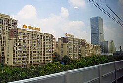
Dantu District (simplified Chinese: 丹徒区; traditional Chinese: 丹徒區; pinyin: Dāntú Qū) is one of three districts of Zhenjiang, Jiangsu province, China. A development called Dantu New City was constructed in the district and was underoccupied since around 2005 and criticized as a ghost city by international media.[2] However, since 2013 the development has been filling up with residents with many operating shops and offices, becoming a functional suburb of urban Zhenjiang.[3][4]
Dantu
丹徒区 | |
|---|---|
 Dantu District in September 2017 | |
| Coordinates: 32°03′16″N 119°31′40″E / 32.0544°N 119.5279°E[1] | |
| Country | People's Republic of China |
| Province | Jiangsu |
| Prefecture-level city | Zhenjiang |
| Area | |
| • Total | 611 km2 (236 sq mi) |
| Population (2011) | |
| • Total | 286,700 |
| • Density | 470/km2 (1,200/sq mi) |
| Time zone | UTC+8 (China Standard) |
| Postal code | 212100 |
There are two islands that belong to Dantu, in addition to the Yangtze River at the north it has a town. It is bordered to the east by the Jiajiang neighborhood in Yangzhong. To the south-east lies Danyang and to the west is Jurong. The Yangtze River borders Dantu to the north.
The district covers an area of 748.8 square kilometers and by 2017, had a population of 288,900.[5] The postal code for Dantu is 212100.
Administrative divisions
editIn the present, Dantu District has 1 subdistrict and 6 towns.[6]
- 1 subdistrict
- Gaozi (高资街道)
- 6 towns
Climate
edit| Climate data for Dantu (1991–2020 normals, extremes 1981–2010) | |||||||||||||
|---|---|---|---|---|---|---|---|---|---|---|---|---|---|
| Month | Jan | Feb | Mar | Apr | May | Jun | Jul | Aug | Sep | Oct | Nov | Dec | Year |
| Record high °C (°F) | 20.8 (69.4) |
26.5 (79.7) |
29.5 (85.1) |
33.5 (92.3) |
36.5 (97.7) |
38.0 (100.4) |
39.5 (103.1) |
38.8 (101.8) |
38.2 (100.8) |
32.5 (90.5) |
29.2 (84.6) |
22.8 (73.0) |
39.5 (103.1) |
| Mean daily maximum °C (°F) | 7.1 (44.8) |
9.7 (49.5) |
14.6 (58.3) |
21.0 (69.8) |
26.2 (79.2) |
29.0 (84.2) |
32.2 (90.0) |
31.7 (89.1) |
27.8 (82.0) |
22.6 (72.7) |
16.4 (61.5) |
9.8 (49.6) |
20.7 (69.2) |
| Daily mean °C (°F) | 3.2 (37.8) |
5.3 (41.5) |
9.8 (49.6) |
15.7 (60.3) |
21.1 (70.0) |
24.7 (76.5) |
28.2 (82.8) |
27.8 (82.0) |
23.6 (74.5) |
18.1 (64.6) |
11.8 (53.2) |
5.5 (41.9) |
16.2 (61.2) |
| Mean daily minimum °C (°F) | 0.1 (32.2) |
1.9 (35.4) |
5.8 (42.4) |
11.1 (52.0) |
16.7 (62.1) |
21.1 (70.0) |
24.9 (76.8) |
24.7 (76.5) |
20.4 (68.7) |
14.4 (57.9) |
8.1 (46.6) |
2.1 (35.8) |
12.6 (54.7) |
| Record low °C (°F) | −9.0 (15.8) |
−11.0 (12.2) |
−5.6 (21.9) |
−0.1 (31.8) |
7.3 (45.1) |
12.1 (53.8) |
18.4 (65.1) |
17.9 (64.2) |
10.7 (51.3) |
3.2 (37.8) |
−4.6 (23.7) |
−12.0 (10.4) |
−12.0 (10.4) |
| Average precipitation mm (inches) | 55.9 (2.20) |
54.5 (2.15) |
81.2 (3.20) |
75.8 (2.98) |
88.8 (3.50) |
184.4 (7.26) |
210.7 (8.30) |
165.2 (6.50) |
78.1 (3.07) |
57.6 (2.27) |
58.9 (2.32) |
39.9 (1.57) |
1,151 (45.32) |
| Average precipitation days (≥ 0.1 mm) | 9.3 | 9.2 | 10.6 | 9.5 | 10.1 | 11.1 | 13.7 | 12.8 | 8.2 | 7.7 | 8.5 | 7.3 | 118 |
| Average snowy days | 3.3 | 2.5 | 0.9 | 0.1 | 0 | 0 | 0 | 0 | 0 | 0 | 0.3 | 1.2 | 8.3 |
| Average relative humidity (%) | 71 | 71 | 69 | 68 | 69 | 76 | 79 | 79 | 76 | 72 | 72 | 69 | 73 |
| Mean monthly sunshine hours | 132.1 | 130.5 | 153.6 | 180.7 | 191.9 | 149.0 | 185.5 | 189.8 | 168.9 | 172.8 | 149.2 | 145.1 | 1,949.1 |
| Percent possible sunshine | 41 | 41 | 41 | 46 | 45 | 35 | 43 | 46 | 46 | 49 | 48 | 47 | 44 |
| Source: China Meteorological Administration[7][8] | |||||||||||||
References
edit- ^ "Dantu" (Map). Google Maps. Retrieved 2014-07-02.
- ^ "And Now Presenting: Amazing Satellite Images Of The Ghost Cities Of China". Business Insider. Retrieved 2019-02-09.
- ^ "Not Deserted! This Chinese Ghost City Is Peopled". www.vagabondjourney.com. Retrieved 2019-02-09.
- ^ Shepard, Wade (1 September 2015). "Ghost Cities of China: A Discussion with Wade Shepard". Chengdu Living. Retrieved 10 September 2015.
- ^ "Population: Jiangsu: Zhenjiang: Dantu | Economic Indicators | CEIC". www.ceicdata.com. Retrieved 2023-10-02.
- ^ "镇江市-行政区划网 www.xzqh.org" (in Chinese). XZQH. Retrieved 2012-05-24.
- ^ 中国气象数据网 – WeatherBk Data (in Simplified Chinese). China Meteorological Administration. Retrieved 25 June 2023.
- ^ 中国气象数据网 (in Simplified Chinese). China Meteorological Administration. Retrieved 25 June 2023.
External links
edit
