This article needs additional citations for verification. (April 2016) |
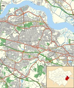
The Belvedere Crossing was a proposed River Thames crossing in East and South East London, running between Rainham in the London Borough of Havering and Belvedere in the London Borough of Bexley.
| Overview | |
|---|---|
| Location | River Thames, East London |
| Coordinates | 51°30′27.01″N 0°9′46.46″E / 51.5075028°N 0.1629056°E |
| Start | Belvedere |
| End | Rainham |
| Operation | |
| Owner | Transport for London |
| Character | Motor vehicles, rail, cycles, pedestrians |
| Route map | |
Plans for the crossing, as well as the Gallions Reach Crossing further upstream, were dropped when Sadiq Khan became Mayor of London in 2016.[1]
Design
editEach crossing was expected to consist of two lanes in each direction – one for public transport and one for general traffic. A charge was proposed for vehicles to use the crossings to manage demand and help pay for the scheme. Any pedestrian and cyclist facilities would be segregated from traffic.[2]
It was considered that the crossing could be integrated into the railway network, most likely by continuing the London Overground Gospel Oak to Barking line extension to Barking Riverside across the river via the new crossing, and connecting to national rail lines at Abbey Wood.[3]
See also
editReferences
edit- ^ Leeming, Lachlan (9 November 2020). "Revive Gallions Reach and Belvedere river crossings, Bexley Council demands". 853. Retrieved 3 May 2023.
- ^ "Gallions Reach and Belvedere". Transport for London. Archived from the original on 19 April 2016. Retrieved 6 April 2016.
- ^ "London's First Highway: The East London River Crossings". London Reconnections. 8 June 2016. Retrieved 6 November 2019.
