This article needs additional citations for verification. (July 2019) |
Ban Bat (Thai: บ้านบาตร, RTGS: Ban Bat, pronounced [bâːn bàːt]; also spelled Banbatt) is one of the five sub-districts (khwaeng) in the Pom Prap Sattru Phai District of Bangkok of Thailand. It has an area of 0.316 km2 (0.122 sq mi). Some parts of the northern area are on the Khlong Maha Nak canal.[2][3] The west side borders the Samran Rat Sub-district of Phra Nakhon District.
Ban Bat
บ้านบาตร | |
|---|---|
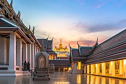
 Wat Saket with Golden Mount in the distance | |
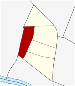
 Location in Pom Prap Sattru Phai District | |
| Country | Thailand |
| Province | Bangkok |
| Khet | Pom Prap Sattru Phai |
| Area | |
| • Total | 0.251 km2 (0.097 sq mi) |
| Population (2019) | |
| • Total | 6,613 |
| Time zone | UTC+7 (ICT) |
| Postal code | 10100 |
| TIS 1099 | 100804 |
History & toponymy
editThe name Ban Bat means "alms bowl community".
Locals believe that their ancestors immigrated from Ayutthaya after its fall in 1767. In 1782, Phyra Phutthayotfa Chulalok (Rama I) established what is today's Bangkok. The refugees settled there, but the date of their migration is unclear. They were known for creating monk's alms bowls, which required handcrafting and manual labor. This tradition has lasted to the modern day. Locals have established the Ban Bat Community, a group that preserves the monk's alms bowl tradition and sells alms bowls to visitors as souvenirs.[3][4]
Ban Bat was also home to the house and band of Luang Pradit Pairoh, who was regarded as a master of traditional Thai music.[5]
Places
editAnother old community, Ban Dokmai, is nearby. It has a tradition of making fireworks ("firework" in Thai called dokmai fai (Thai: ดอกไม้ไฟ; RTGS: dok mai fai; literally 'flame flower'). Similar to the alms bowls of Ban Bat, this tradition may be lost.[3]
Other points of interest include the following:
- Wat Saket and Golden Mount
- Maen Si Intersection
- Sommot Amon Mak Bridge
- Ban Dokmai Palace of Prince Purachatra Jayakara[6]
- Khlong Thom
Moreover, the area around Wat Saket is also a large source of the shops that line a comprehensive range of wood products and handicraft. Currently, some of them have moved to settle in Bang Pho, Bang Sue District.[7]
References
edit- ^ Administrative Strategy Division, Strategy and Evaluation Department, Bangkok Metropolitan Administration (2021). สถิติกรุงเทพมหานครประจำปี 2563 [Bangkok Statistics 2020] (PDF) (in Thai). Retrieved 27 November 2021.
{{cite web}}: CS1 maint: multiple names: authors list (link) - ^ "ประชากรกรุงเทพมหานครและปริมณฑล พ.ศ. 2549" (PDF) (in Thai). Bangkok Metropolitan Administration. Archived from the original (PDF) on 24 June 2020. Retrieved 14 April 2018.[not specific enough to verify]
- ^ a b c พนาราม, อาศิรา (4 June 2009). ""บ้านบาตร – บ้านดอกไม้" ตามรอยแหล่งวัสดุและภูมิปัญญาชุมชนในเขตเมืองเก่า". TCDC (in Thai). Archived from the original on 14 April 2018. Retrieved 14 April 2018.
- ^ "Ban Bat—The Last Buddhist Monk Alms Bowl Makers of Thailand". Nathan Hutchinson, Photographer. 28 August 2016. Retrieved 17 August 2019.
- ^ "บาตรบุ-ที่บ้านบาตร-แถวบ้านนายศร-ศิลปบรรเลง". MUSEUM THAILAND (in Thai).
- ^ Sazabiz (24 September 2015). "วังบ้านดอกไม้". ThaiHRhub (in Thai).
- ^ Malaniyom, Chayaphon (3 May 2021). "ผู้คนค้าขาย แผ่นไม้เล่าเรื่อง : ประชานฤมิตร ถนนสายไม้แห่งบางโพ" [Merchants planks tell stories : Prachanarumit wooden street of Bang Pho]. Sarakadee (in Thai). Retrieved 16 September 2021.
External links
edit- "ข้อมูลแขวงบ้านบาตร เขตป้อมปราบศัตรูพ่าย กรุงเทพมหานคร". ThaiTambon (in Thai).