Adlergrund (Polish: Ławica Orla)[1] is a shoal located in the Baltic Sea, at the SW end of the Rönnebank.
Adlergrund
Ławica Orla | |
|---|---|
 | |
| Coordinates: 54°45′N 14°24′E / 54.750°N 14.400°E | |
| Sea | Baltic Sea |
| Region | Off Cape Arkona |
| Country | Germany |
| Minimum depth | 5 m |
The shoal is a protected marine area with an extension of about 234 km2.[2]
Geography edit
It lies roughly 55 km to the ENE of Cape Arkona, the headland at the northern end of Rügen Island, and 60 km to the SSW of Bornholm. Geographically it is a SW extension of the Rönnebank that runs south of Bornholm.[3] The submerged shoal's shallowest point is about 5 meters deep at the time of the lowest astronomical tide.
History edit
Since it comprises large shallow areas dangerous for navigation, Lightship Adlergrund —a lightvessel of the German Hydrographic Office, was anchored on the reef in the period 1884 – 1914 and again in 1922 – 1941.[4]
-
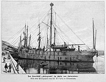 Lightship Adlergrund I (1884)
 -
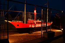 Lightship Adlergrund II (1922)
_b_517.jpg)
.jpg)
Currently the construction of two wind farms is planned on the Adlergrund Shoal under the name Wind Energy Network Rostock project.[5]
See also edit
References edit
- ^ Rozporządzenie Ministra Administracji Publicznej z dnia 11 lutego 1949 r. o przywróceniu i ustaleniu nazw miejscowości in Monitor Polski, 1949; number 17, section 225, p. 5
- ^ BfN - Das Schutzgebiet Adlergrund Archived 2017-09-30 at the Wayback Machine
- ^ GoogleEarth
- ^ Dr Józef Pluciński: Latarniowce na Zatoce Pomorskiej
- ^ "Wind Energy Network Rostock" (PDF). Archived from the original (PDF) on 2010-05-08. Retrieved 2016-08-31.
External links edit
This German location article is a stub. You can help Wikipedia by expanding it. |