Yocemento is an unincorporated community in Big Creek Township, Ellis County, Kansas, United States.[1] The settlement lies across the banks of Big Creek against the base of bluffs capped by massive limestone blocks, in which lies the 20th-century origin of the community.[2][3]
Yocemento, Kansas | |
|---|---|
.jpg) | |
 | |
 Yocemento  Yocemento | |
| Coordinates: 38°54′26″N 99°25′26″W / 38.90722°N 99.42389°W[1] | |
| Country | United States |
| State | Kansas |
| County | Ellis |
| Township | Big Creek |
| Founded | 1906 |
| Platted | 1907 |
| Elevation | 2,051 ft (625 m) |
| Time zone | UTC-6 (CST) |
| • Summer (DST) | UTC-5 (CDT) |
| ZIP code | 67601 |
| Area code | 785 |
| FIPS code | 20-80725 [1] |
| GNIS ID | 484723[1] |
.jpg)
The original settler name for the location was Hog Back,[4][5] with a railway station first established there with that name in 1881.[6] This station was later moved[7] to Hog Back, Kansas. Hog Back was the local name for the high limestone and chalk ridge that runs from just west of old Fort Hays to Ellis. These bluffs are the local outcrop of the Fort Hays Limestone.[8] Established in 1906[9] by business partners Erasmus Haworth, the first state geologist of Kansas,[10] and I. M. Yost, leading businessman and miller of Hays,[11] Yocemento is one of the several communities around the outskirts of the High Plains that were founded to use Fort Hays Limestone to manufacture Portland cement.[12][13][14][15]
History edit
Pre-American settlement edit

The earliest studied human occupation of the Yocemento location is a settlement interpreted as the rarely preserved Early Ceramic (c. 400–1100 CE) Keith phase of the Woodland culture. This phase is evidenced by particular shards of Harlan Cord-Roughened ceramic jars, chipped stone tools (including well-made, small, corner-notched arrowheads), charcoal, bone tools, and mussel shell middens found along the high, steep banks of Big Creek just west of Yocemento. Dating to about 1000 CE, it is interpreted as a butchering and tool working site: Animal bones include bison, deer, and small mammals. The on-site manufacture of stone tools included heat treatment of quartzite, flint, silicified Smoky Hill Chalk, and silcrete. Given that no evidence of permanent occupation has been found here, the site is considered to have been a warm season hunting camp.[17]
Early 18th-century French cartographer Guillaume Delisle's map of the Mississippi River located Padoucas (Comanche) villages on the upper forks of the Kansas River (Big Creek lies between the Smoky Hill and Saline Rivers).[16]
By the early 19th century, however, the Pawnee had a large seasonal hunting camp 11 miles to the south with the Pawnee Trail passing nearby to the east.[18][19][20]
However, by the time of the first United States settlements here in the mid-19th century, the Pawnee had diminished and the general territory was under the claim of the Kiowa and Comanche to the south and west and, more significantly, the Cheyenne and Arapaho to the north and west.[21]
Railroad construction and conflict edit

In 1867, construction of the Kansas Pacific Railway west of Junction City precipitated conflict with the tribes that claimed this region of the High Plains as buffalo hunting grounds.[22] The original public plan for the Kansas Pacific Railway (then UPED) was to follow the Kansas River to Fort Riley, and then progress up the Republican River to Fort Kearny in Nebraska.[23] This course avoided the Cheyenne main buffalo hunting grounds. However, as the tracks reached Junction City, it became clear that the Union Pacific Railroad would win the race to Fort Kearny and the 100th meridian; so, the Kansas Pacific instead surveyed a new course to Denver along the Smoky Hill Trail.[24] Even though the Smoky Hill Trail was more hazardous than either the Santa Fe Trail or Platte River routes, it was the most direct route from the East to Denver.[25]
The rapid construction of track to Salina and up through the Smoky Hills, followed by the letting of contracts to extend railroad out on to the High Plains 100 miles (160 km) west of Ellsworth to Park's Fort,[26][27] was perceived as a violation of Cheyenne and Arapaho territory.[28] From July through August, Dog Soldiers attacked workers and settlers along the line of construction, including near Salina, Bunker Hill, and Wilson. On August 1, seven workers were killed at Campbell's grading camp (present-day Victoria).[29] followed by the Battle of the Saline River the next day just 12 miles north of present day Yocemento. However, it was the September 20[30] attack on Park's Fort, 35 miles (56 km) west of Hays City, that caused a complete halt to surveying and construction west of Hays. Thousands of construction workers, surveyors, and early settlers retreated from the west to the weeks-old settlement of Rome.[31] October construction east of Hays City brought the end-of-track just a few miles short of the future Yocemento site.[32]
This situation was the context of the October 1867 photographs of the Yocemento location made by Alexander Gardner; all construction west of his pictures had halted due to the conflict, but was about to resume:
- One of these Gardner photographs, On the Great Plains, Kansas, 294 miles west of Missouri River[33] (top-right), shows the attraction of the limestone-capped ridge what would draw the attention of future geologists and industrialists, two of whom would eventually create Yocemento there. Notable in the picture is the military escort in the foreground, detached from the 38th Infantry Regiment, reflecting the hostilities with the Cheyenne and allies in those months.[34] Then based in Hays City (5 miles behind the photographer), Buffalo Bill passed over the distant Hog Back on his first hunting contracts.[35] Major Armes had crossed this ridge just weeks before in mid-August with companies of the 10th Cavalry (negro) and the 18th Kansas Volunteer Cavalry (including ex-Confederates) to patrol the surveyed course of the railroad, there engaging large forces of Cheyenne.[30] No construction is visible in this image even though as seen in the following Gardner image, the end of track is only a short distance behind the camera of this picture.[36]
- Another of the photographs taken near the location is the more famous image that Gardner entitled Westward The Course of Empire Takes Its Way.[36] Taken days before the signing of the Medicine Lodge Treaty[37] (wherein the tribes had consented to permit the railroad)[22] the image shows a construction party at end-of-track, which was then only a couple miles west of Hays City. By the time of these photographs (mid/late-October, 1867) Rome had been largely abandoned in favor of the permanent settlement of Hays City.[38]
.jpg)
.jpg)
The railroad comes through edit
The late-August and September battles on the Saline River, Solomon Forks, and tributaries of the Republican River ended the conflict west of the end of line for 1867.[39] With the course of the railroad secured by the U. S. Army and the late-October signing of the Medicine Lodge Treaty, construction of the tracks west of Hays to Park's Fort resumed over the winter of 1867–1868, reaching that pump station before hostilities resumed in April 1868.[40][41][42]
By the end of 1868, the hostilities in western Kansas had concluded and track had reached Sheridan. By 1870, track had reached Denver.[43] The Kansas Pacific promoted settlement, outdoor sport, and tourism in Kansas and Colorado.[44] Ellis had been founded and by 1873 had a Railway Hotel[45] and roundhouse built of Fort Hays Limestone from the bluffs.[46] Photographing these and other features of the rail line, Robert Benecke also photographed the Hog Back between Hays City and Ellis.[47]
.jpg)
.jpg)
Invited to Rome by Buffalo Bill and anticipating the roles Western Kansas farmland and the railroad would play in hard wheat production, I. M. Yost arrived in Hays in 1877 and built the region's first flour mill at the Rome site.[48]
Unsuitable for wheat farming edit
Hays City and Ellis were founded in 1867 and 1870, respectively. However, as fertile as the valley was, the Hog Back ridge of limestone and chalk between the two settlements was considered unsuitable for wheat farming and was initially rejected by immigrant settlers.[49] By 1910, the local press referred to the hill as the "long neglected" Hog Back.[50] Much of these hilltops remain largely in pasture.[51]
Frontier geologists edit

Early frontier geologists were drawn to the monumental limestone bluffs in this location and the chalk exposures beyond. The original interest was in the mapping and study of Cretaceous fossils, this general area of the state becoming a part of the broader focus of the Bone Wars. F. V. Hayden studied the site in 1871. At the time, Big Creek was undercutting the face the bluff, exposing 60 feet (18 m) of "Benton Shale" normally covered by grass on other slopes.[52]
U.S. Portland Cement Company edit
The United States Portland Cement Company was founded by partners Erasmus Haworth and I. M. Yost:

- Erasmus Haworth was the founder and first president of the Kansas Geological Survey at the University of Kansas.[10] He previously had been frustrated in Ellis County, unable to dissuade the 1890s gold rush hoax in the adjoining southern corners of Ellis and Trego Counties about 12 miles (19 km) south and west of present Yocemento (see Smoky Hill City and Chetolah).[53] Accurately predicting the discovery of oil at the Yocemento site, he was later known as the "father of oil" in western Kansas.[54]
- I. M. Yost was a long-standing miller in Hays; a leading businessman not only of that community, but of early 1900s western Kansas. In the 1870s, he built the first of the flour mills that dotted the "Great American Desert" by the first decades of the 20th century.[11]
In 1906, Erasmus Haworth was revising and enlarging his first geological map of Kansas and sought a guide for the area, saying years later, "I had heard of Ike Yost, I wanted to meet the man. I knew he had been in Hays many years and thought he would give me some pointers on topography of the country.[55]
Together, the two climbed the high bluff on a south bend of Big Creek and took in the scene. Riding back to Hays, Haworth pitched the idea of a cement plant at that bluff. He thought this could be the site of the most profitable cement mill in the state; only gravity would be needed to move the limestone from the top of the bluff to a mill in the valley. Yost saw that with no capital investment ample water was to be found in the creek and the transcontinental railroad passing through the site could bring in fuel and ship out cement as far as either coast without freight transfer. Yost also observed that they could leverage the largest industry in western Kansas by founding an adjoining town and selling the lots.[55]
.jpg)

The partners soon founded the United States Portland Cement Company and began selling stock, Yost selling a third of the shares. The town of Yocemento (a portmanteau of Yost and cement) was platted in 1907.[56] A post office opened that same year.[57]
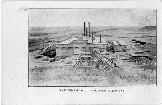
Construction of the mill began in 1907.[58] Freeborn Engineering and Construction Co. of Kansas City, Mo. were the engineers and contractors for the plant.[59] First, a gravity-worked cable lift and then a trolley were installed to lower limestone from the quarry to the mill. By mid-1908, the mill was operational, and the town included a general store, hotel, and restaurant.[60] Many local residents employed at the mill were ethnic Hungarians who had constructed a Catholic church at the site.[9][61]
The mill initially operated at a small profit and the product's test strength was as good as any of the best cements.[55][62] Cement produced in Yocemento was used to build the Kansas City Union Station (then second-largest in the country) and to pave the Denver Tramway.[63][64][65]

Sale of cement to these projects was in competition with the established cement syndicates of Kansas City and Denver. It was locally perceived that these concerns then "ganged up" on the Yocemento mill to force it out of business. In particular, the Denver interests (Boettcher Company) pressured the Union Pacific to not service Yocemento with Colorado coal.[55]
Denied affordable coal, the plains cement mills were able to make use of oil,[66] newly produced in eastern Kansas and Oklahoma. A penny postcard photograph shows three large oil tanks at the Yocemento cement mill.[67]

Missouri cement plants undercut market prices[55] and railroads applied surcharges to the plains cement mills. In 1911, U. S. Portland Cement Co. filed complaint with the ICC for relief from a perceived arbitrary rail freight surcharge of around 3 cents per hundredweight of cement compared to the lower cement shipping rates charged to manufactures in Missouri (between Kansas City and St. Louis).[68] This complaint was joined by several other cement manufactures in the open plains of Nebraska, Kansas, Colorado, Oklahoma, South Dakota, Montana, Texas, and Utah. However, the ICC ruled no evidence of overt shipping overcharge except in the case of Oklahoma. The ICC stated that the cement businesses complaining of excessive shipping charges were in fact suffering from their over-production of cement and the diminishing supply of cheap natural gas used to make the cement.[69]
.jpg)
The mill began losing money and Yost and Haworth had to relinquish control, the company going into bankruptcy a few years later.[55] In March 1916, John Kernan Mullen bought the company for $165,000 in a sheriff's sale. The millionaire flour miller of Denver, who held the first mortgage of the Yocemento mill, bought the facility with the intent to "put the mill in shape and start running it again".[62] In 1917,[9] the Boettcher Company then bought the mill and promptly dismantled it, arguing the plant's remoteness from fuel sources and cement markets made the company nonviable.[55][70][71]
With the mill closed, residents began to leave the community. The post office closed as well.[57] In 1931, the church building was moved to Buckeye Township for use as a community hall.[60]
I. M. Yost moved to Kansas City, then to Denver, and later to California,[55] but remained interested in Hays, returning a few times.[11][72] Erasmus Haworth did not return to Ellis County until 1923, then to survey the Yocemento area for oil.[54]
.jpg)
Yocemento is the location of a grain elevator and bulk fertilizer and chemical warehouse operated by Midland Marketing farmer's cooperative.[73] There are a number of homes, most built long after the closure of the mill. A few of the concrete walls and foundations of the mill remain, parts of which have been remodeled into family homes.[70]
Hydrocarbon production edit
While developing the cement mill, Erasmus Haworth commented that oil would be discovered someday in the anticline he discovered in the area.[54] In 1923, a few years after the mill had closed, Haworth returned to the area just a few miles northwest of Yocemento to drill for oil. His company drilled only one dry hole and then abandoned the effort because of a drop in oil prices. Fortunately for the county and state, later exploration by others proved Haworth correct; his one well had been drilled right between two of the largest producing oil pools in Kansas.[55] At times over the following decades, Ellis County ranked as the top oil producing county in Kansas.[74]
Railroad realignment edit
An abandoned railroad alignment is south of the present county highway, with the original highway alignment lying 300 yards (270 m) to the north in the old townsite. The original alignment of the railroad was cut across the slump blocks that had slid from the slope into the creek, which was undercutting the bluff. Slumping is characteristic on bluffs of the Fort Hays Escarpment, where the deep Carlile Shale weathers away but is unable to support high, steep slopes.[75][76] As in the Benecke photograph of the treeless Hog Back, this slump formed a narrow terrain between the deep banks of Big Creek and the steep slope of the bluff. The blocks of the slump obstructed wagon traffic west from Fort Hays, which found routes over the Hog Back further south.[77][7] The railroad, however, was able to cut a roadbed through the slumping. Unfortunately, the slump was not stable and the railroad repeatedly repaired the shifting roadbed over the decades. By the early 1900s, railroad surveyors considered tunneling through the Hogback.[78] Eventually, the railroad drove many pilings into the bank (still visible from the highway), but failed to stabilize the roadbed. In 1951–52,[79][80] Union Pacific straightened the alignment of the tracks to cut across the bow of Big Creek though the abandoned townsite, also cutting a new channel for the creek about 500 feet (150 m) to the north.[81] The portion of original creek channel at the base of the bluff remains, water still occasionally ponding where Benecke's sportsmen fished in 1873.[82][83][84]
.png)
Highway realignment edit

From the first settlement, wagon travel up the line west of Fort Hays meant either crossing and driving north of Big Creek or crossing over the top of the Hog Back to the south.[7] The ground was too rough at the base of the bluff at Big Creek for wagon traffic; moreover, that passage was occupied by the railroad early on.[85]
The first public road constructed from Hays to Yocemento, originally named "Yocemento Road", was built expressly to connect Hays economically with the expected cement boom at Yocemento. Extending from 12th Street at Hays, the road crossed Big Creek along the old Main Street of Rome and continued along the north of the track to Yocemento.[77][7]
Over 1915–1916, the Ellis County government extended the Yocemento Road to Ellis to complete the county's segment of the Kansas City-Denver Golden Belt Road though the county. The extension started at the section line where the St. Agnes Church stood, running straight west along Third Street (see Yost's plan above) to cross the track; from that crossing, it ran along the south of the track through Ellis.[86][87][88] Much of the Golden Belt Road became U.S. Route 40 in 1926, thus the earliest road from Hays "through the heart" of Yocemento was the only segment of the original "Highway 40" alignment between Wilson and Wallace to run along the north side of the Kansas Pacific tracks, making two grade crossings to do so. Due to the inconvenience and accidents at the west crossing, this matter was eventually corrected.[89]
The problem the railroad was having with the tracks at Yocemento also created an opportunity to improve the Federal highway there. When the railroad moved the tracks well away from the landslide area (1951–52) the new Highway 40 section was also built south of the tracks from a new bridge across Big Creek at Hays to the old crossing just west of Yocemento.[79][80] The old highway north of the track is now maintained by the county, and is named Rome Avenue, running from near the old crossing and passing through Yocemento, and a few miles further on passing the Rome Townsite as it enters Hays.[90]
Geography edit
Yocemento is 1 mile (1.6 km) south of Interstate 70 and 5.5 miles (8.9 km) west-northwest of Hays, the county seat.[3]
Yocemento lies across the banks of Big Creek on the eastern edge of the Chalk Hills area of the Smoky Hills region of the Great Plains.[3][91]
Media edit
The town's newspaper, Yocemento Star, was edited by Frank Motz, then a young man;[55] but, later founder of the Hays Daily News.[92]
Transportation edit
Rail edit
The Kansas Pacific (KP)[3][93] line of the Union Pacific Railroad runs southeast-northwest through Yocemento, with a spur for the grain elevator and bulk supplies.[94]
Highways edit
.jpg)
- Old Hwy 40 (RS 1977)[95][90] (parallel to and south of the railroad tracks, an old alignment of U.S. Route 40[96]) runs southeast-northwest through Yocemento between the old cement plant and quarry to the south and the grain elevator and remainder of the village to the north. This highway is a direct connection between the downtowns of Hays and Ellis.[97]
- Yocemento Avenue runs generally north-south through the community, connecting to Exit 153 of Interstate 70 a mile to the north.[98]
- Rome Avenue runs east-west through the old townsite, then runs north of the track to Hays.[90][99]
See also edit
- Other communities with active and defunct Portland cement plants that used the Fort Hays Limestone:
- Superior, Nebraska (Superior Nebraska Cement Company/Ideal Cement Company)[14]
- Yankton, South Dakota (Western Portland Cement Company)[13]
- Portland, Fremont County, Colorado (Ideal Cement Co./Holcim)[12]
- Laporte, Colorado (Ideal Cement Co/Holcim)[15]
- Guide Rock (Pa-hur), a similar Fort Hays Escarpment bluff, landmark, and sacred site, altered by human action
References edit
- ^ a b c d e U.S. Geological Survey Geographic Names Information System: Yocemento, Kansas
- ^ "Yocemento Once Held Great Promise But Idea Of Founders Born Too Soon". The Hays Daily News. Hays, Kansas. May 24, 1959. p. 12. Retrieved 2018-11-30 – via Newspapers.com.
[the settlement was founded to exploit the limestone]
- ^ a b c d "General Highway Map – Ellis County, Kansas" (PDF). Kansas Department of Transportation. 1978. Retrieved 2015-07-13.
- ^ L.H. Everts & Co. (1887). "The Official State Atlas of Kansas". David Rumsey Historical Map Collection. Philadelphia: L.H. Everts & Co. p. 295 (Ellis Co., Kansas). Retrieved 2018-11-30.
[Hog Back station is shown in its original location just to the west of the Hog Back bluff pictured by Robert Benecke in 1873.]
- ^ "(Notes)". Ellis Review Headlight. Ellis, Kansas. April 20, 1886. p. 4. Retrieved 2018-11-30.
I. M. Saxton, who owns two sections of land a short distance south of Hog Back siding, [Saxton sections seen on the 1887 Everts Atlas of Kansas]
- ^ "(Notes)". Ellis County Star. May 13, 1881. p. 8. Retrieved 2018-11-30.
Hog Back is now a Station and a passing point for trains--next an agent and an operator.
- ^ a b c d Annotated in pencil by George Philip., ed. (1905). Standard Atlas of Ellis County, Kansas. Chicago: Geo. A. Ogle & Co. Retrieved 2018-11-30.
[This map identifies the owner of the land on which Yost built his mill was in 1905 owned by B. F. Replogle. The railroad today crosses the creek on a plate girder bridge. The map also shows the old trail from Fort Hays to the west past the residence of S.A. Turner over the Hog Back. Note also the shift in location of Hog Back from the base of the bluffs (see 1887 atlas) halfway to Ellis. Relocation is commented on in the Normal notes of 1907, as surveyors were setting the point of Hog Back at the later location while they were installing the Yocemento points close to the original location.]
- ^ "Ellis County T. 13 S., R. 19 W." County Geologic Maps. Kansas Geological Survey. Retrieved 2019-01-30.
- ^ a b c "Extinct Towns of Ellis County, Kansas". Legends of Kansas. Retrieved 2018-10-04.
Founded in 1906 by the U.S. Portland Cement Company as the future site of a cement plant, the town site was platted in 1907 and its post office opened in March of the same year. Fifteen months later, in mid-1908, the plant was operational with most of its common laborers being Hungarians. These men and their families were mostly Catholic and at first, held services in their homes. However, in 1906 they built a frame church on a site west of the first bend of Big Creek. In 1910, the small community had a general store, a hotel, a restaurant, and a post office. Situated on the Union Pacific Railroad, some shipping was also conducted. It had a population of about 75 people at the time. Unfortunately, by 1917, the cement plant was losing money and they went into bankruptcy.
- ^ a b Rex C. Buchanan. "'To bring together, correlate, and preserve'--a history of the Kansas Geological Survey, 1864-1989". Retrieved 2019-01-30.
I might have learned that Erasmus Haworth had been the first state geologist and director of the present Geological Survey and that he had mapped the structure on which lies the most productive oil field in Kansas, the El Dorado of Butler County.
- ^ a b c "Yost Who Built Hays Sends Hays Word of Encouragement [after the Wall Street Crash of 1929 ]". The Hays Daily News. November 11, 1929. Retrieved 2018-08-11.
I. M. Yost for many years was a leading business man not only of Hays, but of the entire western half Kansas.
- ^ a b Dawson, John Frank. Place names in Colorado: why 700 communities were so named, 150 of Spanish or Indian origin. Denver, CO: The J. Frank Dawson Publishing Co. p. 41.
- ^ a b Howard E. Simpson. "Geology of the Yankton Area South Dakota and Nebraska" (PDF). Geological Survey Professional Paper. U.S. Department of the Interior.
- ^ a b "Superior Nebraska Cement Company, Trademark Information". Trademarkia. Retrieved 2018-12-09.
- ^ a b "Cement plant closure opens door to uncertain future". AggregateResearch.Com. February 20, 2005. Retrieved 2018-12-09.
- ^ a b Guillaume Delisle (1718), 1718 Carte de la Louisiane et du Cours du Mississipi
- ^ Robert J. Hoard; John R. Bozell; Gina S. Powell (2017). THE KRAUS 1 SITE, 14EL313 A Keith Phase Component in West Central Kansas. Cultural Resources Division, Kansas Historical Society, Topeka. Retrieved 2018-11-30.
- ^ Howard C. Raynesford (1953). "The Raynesford Papers: Notes- The Smoky Hill River & Fremont's Indian Village". Archived from the original on 2003-01-23. Retrieved 2018-08-12.
- ^ 19th Century Kansas Trails (PDF), Kansas Department of Transportation, retrieved 2018-06-12
- ^ Carson Bear (April 4, 2018). "A Nearly Pristine Pawnee Tipi Ring Site Preserved for More Than a Century". National Trust for Historic Preservation. Retrieved 2018-08-12.
- ^ Collins. Kansas Pacific. p. 13.
- ^ a b Marvin H. Garfield (August 1932). "Defense of the Kansas Frontier 1866-1867". Kansas Historical Quarterly. Kansas Historical Society. Retrieved 2019-01-30.
Overland transportation suffered more than did the frontier settlements during 1866. The Smoky Hill route continued to receive its full share of attention by the Indians. This no doubt was due to the fact that the Union Pacific railroad, eastern division, was moving rapidly westward along the Kaw and Smoky Hill valleys and gave promise of soon threatening the favorite buffalo hunting grounds of the red men. ... Tall Bull, a prominent Cheyenne war chief, [at the Medicine Lodge Council] ably stated the Indians' case when he told the commissioners that the red men were on the warpath to prevent Kansas and Colorado being settled by palefaces. He said that the Indians claimed that part of the country as their own, and did not want railroads built through it to scare away the buffalo.
- ^ Robert Collins (1998). Kansas Pacific An Illustrated History. David City, Nebraska: South Platte Press. pp. 7, 13. ISBN 0-942035-46-1.
... Government support favored the Republican Route. ... Fort Kearny in Nebraska
- ^ Collins. Kansas Pacific. p. 13.
Meanwhile, a survey party was sent west out of Fort Riley. Their charge was to plot the best route to a new destination for the railroad: Denver. By then it was obvious that the UP out of Omaha would win the race for the 100th meridian. UPED President John Perry decided it was advantageous to target a more financially promising destination than Fort Kearny in Nebraska. The standing acts of Congress stipulated that the road should follow the Republican River. A few, however, felt that the Smoky Hill Valley would be a far more direct route to Denver, and construction through the valley would be easier. [Fort Riley/Junction City reached in August] That summer the route was officially changed to follow the Smoky Hill river. The survey party had returned with a plan that would have the road first head for the isolated village of Salina.
- ^ "Smoky Hill Trail and Butterfield Overland Despatch". Kansapedia. Kansas Historical Society. Retrieved 2019-01-30.
Many traveled to Denver on the long-established Santa Fe Trail or the Platte River Road but many others chose to make the trip across Kansas on the shorter but more hazardous Smoky Hill Trail.
- ^ Simon Motz, late citizen of Rome and first Mayor of Hays City (July 7, 1961). Leota Motz (ed.). "Hays Had Its Beginning In 1867 With Founding of Rome". Hays Daily News. Hays, Kansas. p. 27 – via Newspapers.com.
Contracts were awarded during the winter of 1866 and 1867 to build the grade as far west as Park's Fort in [future] Trego county.
- ^ W.A. Hill. "Rome – Predecessor of Hays Founded by "Buffalo Bill" Cody". The William F. Cody Archive. pp. 12–13. Retrieved 2018-07-18.
When the Kansas Pacific was ordered constructed from Ellsworth to Parkfort, near [present day] WaKeeney, the Indians declared it should not be. They murdered six employees of the Kansas Pacific near Victoria. ... Also killed two men at the Butterfield station [Lookout] four miles south of Rome. Also Park and his hired men at Parkfort.
- ^ Collins. Kansas Pacific. p. 13.
[After Fort Hays, it] would then enter the country of three nomadic Indian tribes: the Cheyenne, Arapahoe and Kiowa. ... mile and a half per day. ... Then the Indian raids began.
- ^ "Cheyenne Indian Raid Gravesite". Visit Hays (Things To Do). Hays Convention & Visitors Bureau. Retrieved 2018-11-30.
- ^ a b George Augustus Armes (1900). "Chapter VI. 1867". Ups & Downs of an Army Officer. Washington, D.C. p. 253. Retrieved 2018-11-30.
[July and August entries mention the attacks west of Hays City] Camp New Fort Hays, Kan., September 20, 1867 Mr. Parks, in charge of the railroad camp above here, was killed by Indians today.
{{cite book}}: CS1 maint: location missing publisher (link) - ^ Leota Motz, wife of late Frank Motz (July 6, 1961). "Founding of Hays (continued from page 2)". Hays Daily News. Hays, Kansas. p. 29. Retrieved 2018-11-30 – via Newspapers.com.
... burned the buildings Lookout Hollow about 6 miles south of Rome ... About the middle of June the Indians, however, reappeared along the line of the grade and commenced active hostilities by attacking Park's Fort, the extreme western camp on the line. ... Notwithstanding the fact that the Indians were defeated and scattered, the men at the different grading camps refused to continue at their work. The result was a general stampede to Rome, swelling the population to several thousand people. ...
- ^ George Augustus Armes (1900). "Chapter VI. 1867". Ups & Downs of an Army Officer. Washington, D.C. p. 253. Retrieved 2018-11-30.
October 8, 1867. The railroad is just completed, and the cars came into this town for the first time today.
{{cite book}}: CS1 maint: location missing publisher (link) - ^ Alexander Gardner (photographer). Across the continent on the Kansas Pacific Railroad: route of the 35th parallel. p. Plate No. 37.
On the Great Plains, Kansas, 294 miles west of Missouri River
- ^ Leiker, James N. (2009). "Chapter 1: Black Soldiers at Fort Hays, Kansas, 1867-1869". In Braithwaite, Charles A. (ed.). African Americans on the Great Plains: An Anthology. Lincoln: University of Nebraska Press. p. 27. ISBN 978-0803226890. Retrieved 2019-01-30.
- ^ Frederick Moore (1903). "How "Buffalo Bill" Won His Name". The Wide World Magazine. Vol. XI (April 1903 to September 1903), no. 61, April 1903. London: George Newnes, Ltd. p. 44. Retrieved 2018-11-30.
Some strange officers had just joined the railway construction party from one of the military posts farther east, and a few miles outside of camp they came across Cody in his remarkable hunting get-up [coveralls, no shirt, no saddle] just as he had sighted a small "bunch" of eleven buffalo over the crest of a "hog back", about a mile away.
- ^ a b Alexander Gardner (photographer). Across the Continent on the Union Pacific Railway, E. D.
'Westward The Course of Empire Takes Its Way' Laying Track 600 Miles West of St. Louis, Missouri, October 19, 1867
- ^ Peter Cozzens (2001). Eyewitnesses to the Indian Wars, 1865-1890: Conquering the Southern Plains. Stackpole Books. pp. 102–117. ISBN 9780811700191. Retrieved 2019-01-30.
[signings between October 21 and 31]
- ^ At Home in Ellis County 1867–1992. p. 45.
[Businesses moving to Hays in second half of October] With that the war was over and for all practical purposes Rome was dying.
- ^ Collins. Kansas Pacific. p. 23.
- ^ Ray Purinton. "Collyer, KS". The KSGenWeb Project. Retrieved 2018-11-30.
There was a pumping station on the east county line called Park's Fort. ... This was the end of the railroad until after the winter of 1867–1868, ...
- ^ Leota Motz (July 7, 1961). "Founding of Hays". Hays Daily News. Hays, Kansas: 22. Retrieved 2018-11-30.
A short time after the trouble with the Indians the contractors re-occupied their camps and resumed work. This depleted the population of Rome and business languished for a short period. The arrival of additional troops and civilian employees in the quartermaster's department was sufficient to continue the activity in the saloon traffic.
- ^ Collins. Kansas Pacific. p. 23.
The spring of 1868 saw the UPED with some 375 miles of track in service. Yet again, Indian raids proved a threat to survey parties and construction crews. [The U. S. Army responded with decisive force] By the end of September the trouble had passed.
- ^ Collins. Kansas Pacific. p. 25.
- ^ Robert Benecke (photographer) (1873). On the Kansas Pacific Railway. Retrieved 2019-01-30.
In late October 1873, Benecke traveled from Kansas City to Denver, commissioned by the Kansas Pacific Railway to photograph sites of interest for the company's promotional use. [Promotional elements of this KP sponsored work include pictures of sportsmen hunting and fishing (No. 21, 45, & 51), natural landmark features (No. 32, 42, & 51) tourist hotel (No. 62).]
- ^ On the Kansas Pacific Railway. p. No. 49. Railway Hotel at Ellis, built of stone from the Ellis Quary.
- ^ On the Kansas Pacific Railway. p. No. 52. Kansas Pacific Railway Roundhouse at Ellis, Kansas.
- ^ On the Kansas Pacific Railway. p. No. 51. The 'Hog Back' at Ellis, Kansas.
- ^ W.A. Hill. "Rome – Predecessor of Hays Founded by "Buffalo Bill" Cody". The William F. Cody Archive. pp. 12–13. Retrieved 2018-07-18.
One of [Cody's] greatest contributions to Hays was when he got I. M. Yost to locate here.
- ^ Francis S. Laing (1910). German-Russian settlements in Ellis County, Kansas. Kansas State Historical Society. Retrieved 2018-11-04.
[1875] The first land shown was near Hog Back, but this pleased so little that the men determined to return to Russia. [they eventually settled in Herzog/Victoria]
- ^ "Yocemento Cement Plant". Free Press. Hays, Kansas. May 5, 1908. p. 1. Retrieved 2018-11-30.
When last year president I. M. Yost and treasurer J. H. Ward talked "Cement Works at Hog Back," lots of our people scoffed. But when the commercial clubs of Kansas City and Salina were here, both parties were accompanied by many of our citizens inspected the works, saw the immense machinery in full operation, saw thousands of tons of rock out and broken up, ready to be rolled down into the steel choppers, grinders and bakers, and they swelled with pride that way out here on the prairie, out there at those long neglected hills of old "Hog Back" in Ellis County was a $900,000 cement works, ready to turn out and help fill the great demand for the building material of the Romans and of America today.
- ^ Google (January 31, 2019). "Yocemento, Kansas" (Map). Google Maps. Google. Retrieved January 31, 2019.
- ^ F. V. Hayden, United States Geologist (1871). "IX. Sketch of the geological formations along the route of the Union Pacific Railway, Eastern Division". Final Reports of the United States Geological Survey of Nebraska and Portions of the Adjacent Territories. House Documents, otherwise Publ. as Executive Documents United States. Congress. House. Washington: Government Printing Office. pp. 66–69. Retrieved 2018-10-04.
At Hays City the massive rocky layers of No. 3 are sawed into blocks, and employed in the construction of buildings. ... About eight miles west of Hays City there are about 60 feet exposed, of the dark clays of No. 2, of the Fort Benton Group.
- ^ Dan Plazak (2007). "The imaginary gold mines of Kansas" (PDF). Mining History Journal. 14: 11–22. Retrieved 2018-11-30.
{{cite journal}}: CS1 maint: numeric names: authors list (link) - ^ a b c ""Midnight Oil" Burned On Hill When Hays Men Were Sure They Had Struck It Rich". The Hays Daily News. Hays, Kansas. November 11, 1950. Retrieved 2018-10-04 – via Newspapers.com.
This man is none other than Professor Erasmus Haworth widely known now as the "father of oil" in Western Kansas. ... Haworth didn't return to Ellis County until 1923.
- ^ a b c d e f g h i j "Yocemento Once Held Great Promise But Idea Of Founders Born Too Soon". The Hays Daily News. Hays, Kansas. May 24, 1959. p. 12. Retrieved 2018-11-30 – via Newspapers.com.
Then eastern Kansas competitors began cutting prices under the market price and Yocemento which had been laughed at in the beginning was threatened. Competitors began to dig into their volume of business. They ganged up it was said on their Western Kansas competitor. About this time the Boettcher Company's cement interests of Denver began expanding activities, built new cement mills in Colorado and told the Union Pacific flatly they didn't want competition from the Yocemento mill. This was the added weight that eventually broke the back of Yocemento.
- ^ I. M. Yost (July 7, 1907), Plan of Yocemento, Mill and Ground, retrieved 2018-11-30
- ^ a b "Kansas Post Offices, 1828–1961 (archived)". Kansas Historical Society. Archived from the original on October 9, 2013. Retrieved 2014-06-09.
- ^ "Personal Column". Engineering and Mining Journal. 84. Western & Company: 458. 1907. Retrieved 2018-11-30.
Erasmus Haworth is building a cement mill for the U. S. Portland Cement Company at Yocemento, ...
- ^ "Manufacturing Plants". Engineering World. 3–5. International Trade Press: 111. 1906. Retrieved 2018-11-30.
We are advised that work has begun on the new 1,000-bbl. cement plant for the Uncle Sam Portland Cement Co., at Yocemento, ...
- ^ a b "Historical Mt. Allen Cemetery". City of Hays. Retrieved 2018-11-30.
- ^ "Yocemento w". www.ksgenweb.org. Retrieved 2018-11-04.
It was these citizens who built St. Agnes Catholic Church. At one point there was a general store, a hotel, and a restaurant in Yocemento. Later, the church was abandoned as people moved away, and the building was moved to the Buckeye community in 1931 to be used as a community hall.
- ^ a b "Sell Cement Plant". The Wilson World. Vol. XXXIX. Wilson, Ellsworth County, Kansas. March 30, 1916. Retrieved 2018-08-11 – via Newspapers.com.
Portland cement plant has been sold by the sheriff to J. K. Mullen, the miller millionaire of Denver for $165,000 … The cement is known the world over has been recognized and is as near the standard of the Portland cement of England … title to it for six months. It is their intention to put the mill in shape and start running it again.
- ^ At Home in Ellis County 1867–1992. Vol. 1. Ellis County Historical Society. 1991. pp. 69, 151, 286.
Cement produced in Yocemento was used to build the Union Station in Kansas City and to pave the Denver Tramway.
- ^ Morrison, Denise (March 28, 2018). "History question about the Union Station" (Email). Letter to.
Yes, as you allude to in your email, all the plaques we installed when we reopened Union Station in 1999 were taken down for remodeling within the last 10 years or so and just haven't been re-installed. I believe the plaque you are referring [Yocemento] to was on the second floor in the hallway leading to the link to Crown Center and that whole area changed dramatically with the coming of the streetcar. They are going back up, ... I'm keeping all the plaques safe in our collections storage area.
- ^ Collections & Curatorial Services (1999). Yocemento (bronze plaque). Kansas City, Missouri: Kansas City Museum.
[1999 plaque commemorating the source of the cement used to build the Union Station was removed to collections storage in later remodeling.]
- ^ Mineral Resources of the United States, Calendar Year 1910, Part 2 – Nonmetals. Department of the Interior – United States Geological Survey. 1911. p. 500. Retrieved 2018-11-30.
All of the plants, including the one at Yocemento, are using oil exclusively, ...
- ^ "The Cement Mill, Yocemento, Kansas". Penny Postcards from Kansas – A USGenWeb Archives Web Site. Retrieved 2018-11-30.
- ^ "Interstate Commerce Commission (Complaints Filed)". Railway World. 55: 1142. 1911. Retrieved 2018-11-30.
[Complaint] No. 4569 -- United States Portland Cement Co., of Yocemento, Kan., against the Union Pacific Railroad Co., et al. Against an arbitrary of 3c per 100 pounds on shipments of cement moving from Yocemento, Kan., to points in Montana.
- ^ "Interstate Commerce Commission Hands Down Rulings on Contested Cases: Opinion No. "Should Establish Parity". The Traffic World and Traffic Bulletin. 9. Traffic Service Corporation: 1186–1189. 1912. Retrieved 2018-08-11.
- ^ a b At Home in Ellis County 1867–1992. p. 69.
They dismantled most of the mill at once; but parts of it still stand and have been remodeled into family homes.
- ^ Standard Atlas of Ellis County, Kansas. Chicago: Geo. A. Ogle & Co. 1922. Retrieved 2018-11-30. The map records the title for the quarry and plant sites is held by Charles Boettcher.
- ^ H. R. Pollock. "Blueprint of Rome, Kansas". The William F. Cody Archive. Retrieved 2018-07-18.
- ^ "About Us". Midland Marketing Co-op. Retrieved 2018-11-04.
- ^ Willie Mannebach (July 4, 1976). "Haworth Develops Area Oil Industry". Hays Daily News: 54. Retrieved 2018-10-11.
- ^ K. R. Neuhauser. Department of Earth Sciences, Fort Hays State University (1988). "A Kinematic Analysis of Slump Blocks Along the. Saline River Valley, Ellis County, Kansas". Transactions of the Kansas Academy of Science. 91 (3–4): 169–177. doi:10.2307/3628352. JSTOR 3628352.
... by rotational creep about a concave-upward plain in the less competent Codell Sandstone and the incompetent Blue Hills Shale [of the Carlile Shale formation].
- ^ Russell T. Runnels; Ira M. Dubins (1949). Chemical and Petrographic Studies of the Fort Hays Chalk in Kansas, Kansas Geological Survey, Bulletin 82 Part 1. University of Kansas Publications, State Geological Survey of Kansas. p. Stratigraphy. Retrieved 2018-11-30.
Slumping is common in the Fort Hays, ...
- ^ a b "Yocemento Road". The Hays Free Press. Hays, Kansas: 4. February 2, 1910. Retrieved 2017-02-16.
Years ago there was such a road and it was much traveled. It [ran] to the Replogle creek crossing, then up his road around Hogback and back to the track. [This article, discussing construction of a road to the new cement mill at Yocemento, lists George Palmer, Bruel, Sach, and Zeigler (at the old Rome townsite.) all shown as land owners along the right-of-way in the Standard Atlas of Ellis County, Kansas, 1905.]
- ^ "Normal Notes". The Hays Free Press. Hays, Kansas. February 2, 1907. Retrieved 2018-11-04 – via Newspapers.com.
The Railroad surveyors were busy this week setting the stakes for the new switches at Hogback and Yosemento [sic]. They were undecided whether or not to recommend tunneling through the Hog Back hill. Some favor the Cement company making the tunnel, using the shale to make cement, and then the railroad use the tunnel.
- ^ a b "Hays Bridge Contract Let". The Salina Journal. Salina, Kansas. March 4, 1951. p. 13. Retrieved 2018-11-30 – via Newspapers.com.
The new road to be built south of the tracks from the west edge of Hays to the UP Railroad crossing west of Yocemento, is known as the Yocemento project. ... Cushing made no comments on ... the amount of money the Railroad will spend to move its tracks to a new roadbed north of the present right of way at Yocemento.
- ^ a b "Western Kansas Gets Bid on US40 Project". Hutchinson News. Hutchinson, Kansas. March 6, 1951. p. 10. Retrieved 2018-11-30.
... the new project will probably start within 60 days.
- ^ nwkrailfan (July 21, 2013). "Signal Sunday: Yocemento, KS". Trainorders.com. Western Railroad Discussion. Retrieved 2018-11-30.
Prior to 1947 [newspapers have the highway contracts let in 1951] in the Union Pacific tracks ran on the north side of the elevator and made a slight curve to run along the river bluffs to the south, after several landslides the UP made the decision to realign the tracks to a straight alignment and cut across the river bottoms.
- ^ On the Kansas Pacific Railway. p. No. 51. The 'Hog Back' at Ellis, Kansas.
[the course of the channel is traceable to the watery channel seen in the Google maps image of April 24, 2016.]
- ^ Google (January 31, 2019). "Yocemento, Kansas" (Map). Google Maps. Google. Retrieved January 31, 2019.
- ^ "Hangman's Bridge Hays City, Kansas". The Historical Marker Database. Retrieved 2018-07-19.
- ^ On the Kansas Pacific Railway. p. No. 51. The 'Hog Back' at Ellis, Kansas.
The image shows that in 1867, the railroad took its right-of-way over and through the slump blocks; wagon traffic having to either cross the hock Back to the south or the creek ravine to the north.
- ^ Standard Atlas of Ellis County, Kansas. Chicago: Geo. A. Ogle & Co. 1922. Retrieved 2018-11-30.
[This map records the pre-1951 alignment of the Golden Belt Road/Union Pacific Highway through Yocemento. ]
- ^ "Commissioners Proceedings (Hays, Kansas, March 1, 1915)". The Ellis Review-Headlight. Ellis, Kansas: 3. March 12, 1915. Retrieved 2018-11-30.
The meeting was called to order by the Chairman. The matter of grading the Golden Belt Road, beginning at the southwest corner of section six (6), [etc.] ... The County Surveyor was instructed to [survey] said road as described. Said road to be thirty (30) feet wide. ... On motion of Commissioner Grabbe the Board adjourned to 1:30 p m. The Board met pursuant to adjournment, all members present. The matter of grading and building bridges on the Golden Belt Road from Yocemento west, coming before the Board, same was ordered passed until Monday, March eighth, at 9 am, and the County Surveyor instructed to view and report on said road and examine the old Palmer bride and report on the possibility of using the bridge on said road.
- ^ "No Good Samaritan?". The Hays Free Press. Hays, Kansas. September 23, 1916. p. 1. Retrieved 2018-11-16.
[The story describes regular auto traffic on a completed Golden Belt Road.]
- ^ At Home in Ellis County 1867–1992. p. 45.
During the 1920's and 1930's [sic] U.S. 40 went through the heart of Yocemento. That's why the two large cement bridges were built. The low-water bridges had washed away nearly every spring. U.S. 40 originally crossed the railroad tracks around the curve to the west; and there were so many accidents, that the highway was moved south of town on the other side of the railroad and creek.
- ^ a b c "City of Hays / Ellis County GIS Viewer". Retrieved 2016-07-04.
- ^ "2003–2004 Official Transportation Map" (PDF). Kansas Department of Transportation. 2003. Retrieved 2015-07-16.
- ^ "Motz, Frank". kspress.com. Kansas Press Association. Retrieved 2018-11-30.
- ^ "UPRR Common Line Names" (PDF). Union Pacific Railroad. Retrieved 2015-07-16.
- ^ "Midland Marketing Locations". Midland Marketing. Retrieved 2019-01-30.
Yocemento: Handles dry and liquid fertilizer along with NH3, bulk chemicals, also mixes, dry fertilizer with seed wheat.
- ^ "General Highway Map, Ellis County, Kansas" (PDF). 2016. Retrieved 2016-07-04.
- ^ "Official 1960–61 Kansas Highway Map" (PDF). Kansas Department of Transportation. Retrieved 2015-07-16.
- ^ Kansas 2005–2006 Official Transportation Map
- ^ "Yocemento, KS". Google Maps. Retrieved 2015-07-16.
- ^ Margaret Allen. "Noose Road changed to Rome Avenue". The Hays Daily News. Retrieved January 31, 2021.
.jpg)