Wikipedia:Graphics Lab/Map workshop/Archive/Aug 2010
Stale edit
Wikipedia friendly colors edit

Article(s): unemployment
Request: Wikipedia friendly colors... Chris (クリス • フィッチュ) (talk) 15:21, 12 June 2010 (UTC)
Graphist opinion(s):
Byzantine maps edit


This map (the right one) is wrong. Basilicata (or Lucania) was a byzantine territory. See here. The left image is wrong because Liguria in 626 was still Byzantine (it fell to the Lombards only in 641):
“King Rothari [636-652] then captured all the cities of the Romans which were situated upon the shore of the sea from the city of Luna (Luni) in Tuscany up to the boundaries of the Franks. Also he captured and destroyed Opitergium (Oderzo) a city placed between Tarvisium (Treviso) and Forum Julii (Cividale). He waged war with the Romans of Ravenna [3] near the river of Emilia which is called the Scultenna (Panaro). In this war eight thousand fell on the side of the Romans and the remainder took to flight. [...]” (Paul the Deacon, IV, 45)
Please, correct them.--79.23.31.7 (talk) 15:47, 21 June 2010 (UTC)Michele from Italy.
- For corrections to existing maps I'd try contacting the original authors of the maps first, it would be easier for them to fix than to try and recreate their work - for the Italy map that is User:MapMaster, for the Byzantine one User:Justinian43. Kmusser (talk) 16:04, 21 June 2010 (UTC)
Portuguese India edit
-
 Map showing various Portuguese Indian Ocean domains around the early 16th century.

Article(s): Battle of Diu (1509)
Request: Please vectorize it so that I can upload it to Commons. Pikolas (talk) 17:58, 23 June 2010 (UTC)
Graphist opinion(s): By vectorize I assume you mean convert to SVG, yes? You can upload it to the Commons as it is, it doesn't have to be in SVG format. The template used on the image page is misleading, see Template talk:Convert to SVG and copy to Wikimedia Commons. Pfly (talk) 09:39, 25 June 2010 (UTC)
Resolved edit
Switzerland edit
-
 Map showing how Muammar al-Gaddafi’s proposal for the dismemberment of Switzerland might work out

Article(s): Libya–Switzerland relations
Request: Please translate the names of France, Germany, Italy and Switzerland from German to English on this map. City of Destruction (The Celestial City) 13:28, 28 July 2010 (UTC)
- Have you tried to contact the original author? This map is a PNG, which makes replacing the names a little less easy than it would have been with an SVG. Classical geographer (talk) 16:38, 28 July 2010 (UTC)
- While I applaud you for bringing me to one of the more colorful & amusing wikipedia events articles I've seen, I'm not sure this belongs on Wikipedia per WP:OR. I don't think it would be particularly difficult to change the names, either if kept as an PNG or converted to SVG, but keeping the font would be difficult. I think the deciding factor should be: Are the noted borders either trivially obvious or directly referenced from the UN speech, or would it be possible to draw other conclusions on the precise lines of division from the proposal? Lesqual (talk) 17:21,
28 July 2010 (UTC)
- Thank you for translating it, a map that I'm sure that can hardly be very popular in Switzerland. I actully came across it on an external website, and no, I haven't contacted the original creator though I can if that would be helpful. As to whether this map is original research, I would say it probably isn't as these are precise boundaries based on the linguistic regions of Switzerland, as per Gaddaffi's suggestion that German-speaking Switzerland should become part of Germany and so forth.
-
 Map showing the linguistic divisions of Switzerland

Graphist opinion(s):
![]() Request taken by Sudoman.
Request taken by Sudoman.![]() Done
Done
-
 Map showing how Muammar al-Gaddafi’s proposal for the dismemberment of Switzerland might work out

Switzerland Linguistic Divisions edit
-
Map showing the linguistic divisions of Switzerland
Article(s):linguistic regions of Switzerland
Request: Incidently, would it be possible to also translate the names of German, French, Italian and Romansh on the colour key of this map below, which shows Switzerland's linguistic divisions? City of Destruction (The Celestial City) 22:38, 28 July 2010 (UTC)
Graphist opinion(s):
![]() Request taken by Lesqual.
Request taken by Lesqual. ![]() Done
Done
-
 Map showing the linguistic divisions of Switzerland

A question, however. I'm not sure I should be uploading entirely new filepages for something this trivial. Is this the appropriate way to upload a simple non-copyrightable English translation, for a German file that is used on both EN and DE wikipedias? Lesqual (talk) 23:39, 29 July 2010 (UTC)
- Thank you. As to your question, I'm not familiar with policy in this matter so I'll leave to someone more knowledgeable to answer. City of Destruction (The Celestial City) 00:18, 31 July 2010 (UTC)
- The recommendation on commons is to save translated files as <filename>-code.<ext> (replace 'code' with the two-letter country code for the translation). For SVG files, there's an easy way to do this via SVGtranslate and/or a {{Translation possible}} template (for an example, see file:Galvanic Cell.svg). gringer (talk) 07:46, 7 August 2010 (UTC)
Map border fix edit
-
 Map of the districts of the Boy Scouts Coronado Area Council

Article(s): Coronado Area Council
Request: Could someone please fix the state border around the shaded counties so that is is the same thickness as it is around the unshaded portion of the state? Thanks, Ks0stm (T•C•G) 20:56, 15 June 2010 (UTC)
Graphist opinion(s):
![]() Request taken by Lesqual.
Request taken by Lesqual.![]() Done
Done

Sometimes, it's easier to make a new one than to fix it. Here you go. Lesqual (talk) 02:32, 27 July 2010 (UTC)
- Thanks, but if you look at the counties, the borders of the counties are kinda messed up in the new one...the way they should look is the same as in the old one. Ks0stm (T•C•G) 17:26, 27 July 2010 (UTC)
- While that wasn't intentional, for this article I question whether it's problematic. The borders aren't 'messed up', they're simply generalized to a greater degree than the other map. This saves Wikipedia bandwidth and rendering time, and is good SOP when extra detail would be superfluous to comprehension. Even if it does detract slightly for you, the fact that the source data I picked uses proper polygons for counties and linework for boundaries, rather than the messy automatic vectorization that the other image uses, makes it worthwhile for future editors because one can fix things like border width painlessly. Lesqual (talk) 20:17, 2 August 2010 (UTC)
- I'd have to agree with Ks0stm on this one, the higher level of generalization on your map did some strange things, making counties that should have square borders no longer square. The original's vectorization is pretty good (compare with File:Kansas counties map.png). I'll grant that at the size used in the article it won't be very noticeable, but I also don't think it's an improvement over the original. Kmusser (talk) 21:00, 2 August 2010 (UTC)
- I think I've got the original fixed. Kmusser (talk) 14:28, 3 August 2010 (UTC)
- While that wasn't intentional, for this article I question whether it's problematic. The borders aren't 'messed up', they're simply generalized to a greater degree than the other map. This saves Wikipedia bandwidth and rendering time, and is good SOP when extra detail would be superfluous to comprehension. Even if it does detract slightly for you, the fact that the source data I picked uses proper polygons for counties and linework for boundaries, rather than the messy automatic vectorization that the other image uses, makes it worthwhile for future editors because one can fix things like border width painlessly. Lesqual (talk) 20:17, 2 August 2010 (UTC)
Please make map Wikipedia-friendly edit
-
 WXK92 coverage map

Article(s): WXK92
Request: Could someone please make this more Wikipedia-friendly, possibly an svg...the high detail of the coverage area doesn't have to stay (it can be more generalized or completely eliminated), but the alerted counties still need to be highlighted somehow and the transmitter location marked. Thanks in advance, Ks0stm (T•C•G) 20:05, 6 July 2010 (UTC)
Graphist opinion(s):![]() Request taken by Thylacine222.
Request taken by Thylacine222.
There's a PDF version of the graph on the same page which has vector data, so I just need to fix the colors, some of the text as well as the location of the weather station. Thylacine222 (talk) 18:48, 3 August 2010 (UTC)

How's this? Thylacine222 (talk) 21:51, 3 August 2010 (UTC)
- I altered it to where the unshaded counties represent the ones alerted, but the map is fine otherwise. Many thanks! Ks0stm (T•C•G) 00:24, 4 August 2010 (UTC)
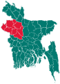
Rajshahi/Rangpur maps edit
-
 Old Rajshahi province
 -
 Bangladesh divisions in English
 -
 New Rajshahi province (রাজশাহী বিভাগ) and Rangpur province (রংপুর বিভাগ)
 -
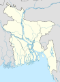 Need to separate Rajshahi and Rangpur provinces as it's done here


Article(s): Rangpur Division, Rajshahi Division
Request: Need to make separate maps for a Rajshahi and Rangpur divisions which were separated this year. Bangladesh location map already has these new borders but need to update provincial map. Hugo.arg (talk) 10:37, 21 June 2010 (UTC)
Graphist opinion(s):
![]() Request taken by MarsInSVG.: 2010-07-27
Request taken by MarsInSVG.: 2010-07-27
-
 Rangpur Division
 -
 Rajshahi Division


Black Mamba edit
-
 This is not a Black mamba distribution map. It is the only map I could find that is close to the actual Black mamba's distribution.

Article(s): Black mamba
Request: I want to request a distribution map for the Black mamba. Its distribution though under somewhat dispute seems to be in accordance with the National Geographic map that is located on this page: http://animals.nationalgeographic.com/animals/reptiles/black-mamba.html However, the JSTOR article may be more reliable, but the source can only be view by members. The information is cited on the Black mamba page under distribution. Do not hesitate to contact me on the talk page. Cheers! Reddevil1421 (talk) 00:58, 20 May 2010 (UTC)
-
 Black Mamba Range

How about this? The conventions here are a bit confusing, but here you go. It looks fine in Illustrator, but you might want to increase line weights or generalize out the national borders depending on how it looks rendered into low-res PNG thumbnails. Lesqual (talk) 19:57, 19 July 2010 (UTC)
- Okay, after 20 hours I guess the problem here is not just Wikipedia slowly caching things... for some reason this image won't render into a PNG. Any idea why? Lesqual (talk) 16:36, 20 July 2010 (UTC)
Graphist opinion(s):
You could try WP:LIBRARY to get access to the JSTOR article... if we can get that mirrored somewhere I'm sure someone here can modify a map for it. — raeky (talk | edits) 20:15, 19 July 2010 (UTC)
Given the disinterest (this appears to have been the focus of a school project which ended), I've placed it on the page myself and marked it ![]() Done & resolved. Lesqual (talk) 23:40, 26 July 2010 (UTC)
Done & resolved. Lesqual (talk) 23:40, 26 July 2010 (UTC)
Kingdom of Sardinia 1815 edit
-
 Map of the Kingdom of SARDINIA 1815

Article(s): Kingdom of Sardinia
Request: This image is wrong, lacking of Nice and Savoy (Here the correct map]. Can you arrange our little wikipedinian map?Jonny Bee Goo (talk) 23:16, 25 July 2010 (UTC)
Graphist opinion(s):
![]() Request taken by Lesqual.
Request taken by Lesqual.![]() Done
Updated to reflect source. Lesqual (talk) 07:02, 13 August 2010 (UTC)
Done
Updated to reflect source. Lesqual (talk) 07:02, 13 August 2010 (UTC)
Baja California cities are shown out in the Pacific Ocean edit
Article(s): Tijuana; Ensenada, Baja California; Playas de Rosarito, Baja California
Request: Something must be wrong with the Mexico pushpin map. Several of the coastal cities in Baja California Norte, Mexico, are shown too far north and too far west - the pushpin locates them in the ocean, offshore from San Diego. The coordinates provided in the articles appear to be correct, so the problem is most likely with the map. Thanks for taking a look at this and returning those cities to dry land! MelanieN (talk) 15:03, 13 August 2010 (UTC)
Graphist opinion: ![]() Done that map was in the wrong projection to use with pushpin maps, should be fixed now. Kmusser (talk) 15:43, 13 August 2010 (UTC)
Done that map was in the wrong projection to use with pushpin maps, should be fixed now. Kmusser (talk) 15:43, 13 August 2010 (UTC)
- Well, thanks for whatever you did, but it didn't solve the problem; all three cities are still offshore. --MelanieN (talk) 16:53, 13 August 2010 (UTC)
- You may just need to clear your cache - they are showing correctly for me, you can tell if the pushpin template is using the correct map by looking at the U.S.-Mexico border near San Diego, on the old map the border was parallel to the top map edge, on the new map it has a slant to it. Kmusser (talk) 17:30, 13 August 2010 (UTC)
Beirut location map edit
Kmusser (talk) 14:08, 16 August 2010 (UTC)
Article(s): Beit Beirut National Museum of Beirut Beirut
Request: Hey guys, i need a location map for Beirut related articles; using the Lebanon location map does not yield the needed result at all, i found these reliable maps online, the first is by the beirut municipality, complete with district names and green spaces, yet the new marina area is shaded in grayish color although that is where the sea lies. the second is by the lebanese army , sadly it is embedded in flash and can only be viewed one portion at a time by scrolling municipal map LAF map Eli+ 12:03, 7 August 2010 (UTC)
Graphist opinion(s):
-
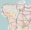 Street map of Beyrouth/Beirut.

- well, i used the map on the National Museum of Beirut article, i checked my coordinates twice, the red dot shows to the north to where the actual location of the museum is. The museum sits at the edge of the Beirut hippodrome (the large, green elliptical shape on the location map) but on this map it appears to be somewhere around the Saint Joseph University campus. You can check what i mean yourself by following the coordinates on google. There is something else, the map is a bit outdated, the new beirut central district claimed land area is finished, but it still appears to be filled with water, and please, don't get me started with the street labels, i wish we could hide this layer altogether, it's not just incorrect and misleading but isn't useful. Thank you for your time, i wish i could be more of use and just make the map myself but i don't know where to start. Eli+ 18:42, 9 August 2010 (UTC)
- I think the problem is on Template:Location_map_Lebanon_Beirut, shouldn't the center point there be the same as the center point on the image description (33.8864,35.4937)? I didn't check to see if the border coordinates are correct. Kmusser (talk) 18:59, 9 August 2010 (UTC)
- I think I have the coordinates fixed - at least the museum looks like it's showing up in the right place. Kmusser (talk) 17:19, 10 August 2010 (UTC)
I fixed a map with the actual borders and districts.
-
 Street map of Beyrouth/Beirut.
