| Category 1 hurricane (SSHWS/NWS) | |
 Hurricane Gil south of Mexico | |
| Formed | July 30, 1989 |
|---|---|
| Dissipated | August 5, 1989 |
| Highest winds | 1-minute sustained: 85 mph (140 km/h) |
| Lowest pressure | 979 mbar (hPa); 28.91 inHg |
| Areas affected | Mexico |
| Part of the 1989 Pacific hurricane season | |
Hurricane Gil was a minimal category 1 hurricane that formed and dissipated in the Pacific Basin during the moderately active 1989 Pacific hurricane season. It was the 7th named storm and 4th hurricane of the 1989 Pacific hurricane season. Its outer bands produced very significant rainfall and triggered deadly flooding.
Meteorological history edit

Tropical storm (39–73 mph, 63–118 km/h)
Category 1 (74–95 mph, 119–153 km/h)
Category 2 (96–110 mph, 154–177 km/h)
Category 3 (111–129 mph, 178–208 km/h)
Category 4 (130–156 mph, 209–251 km/h)
Category 5 (≥157 mph, ≥252 km/h)
Unknown

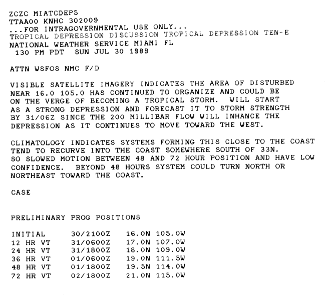
Gild formed from an area of disturbed weather located near the Mexico–Guatemala border developed a circulation in the Gulf of Tehuantepec and then dissipated. On July 30, the disturbance redeveloped a circulation and then convection. It paralleled the coast of Mexico and headed in a northwesterly direction. The continued to organize, and was upgraded into a tropical depression. Initially, there was some uncertain in the storms future path, and there was a possibility of the system recurving towards the coast. [1]
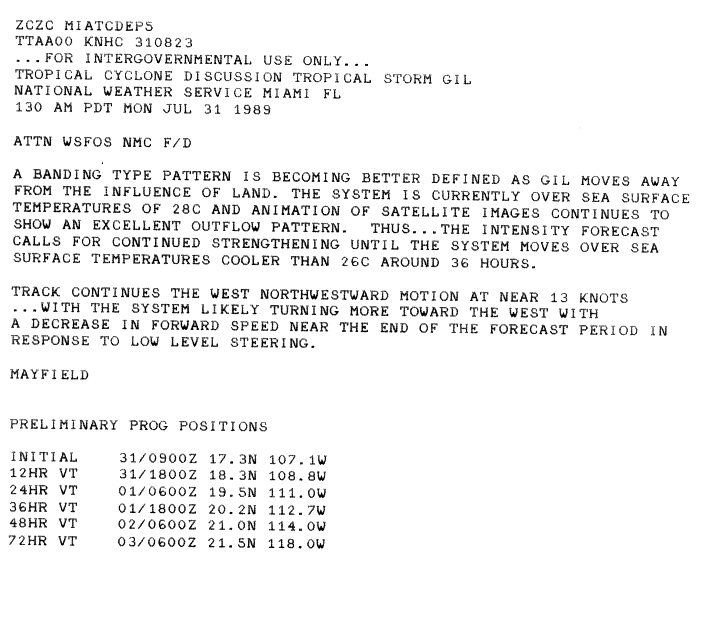
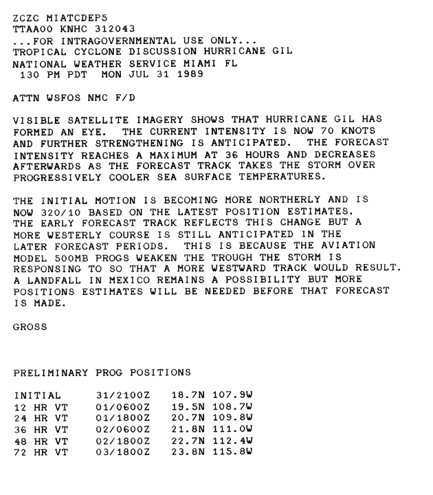
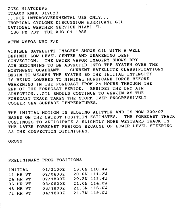
The depression strengthened into a tropical storm on July 31. The system continued to become better organized, with further intensification forecasted because the low was located over very warm waters; [2] and was upgraded into a hurricane that same day. Shortly thereafter, the cyclone developed an eye, [3] and reached its peak intensity of 85 miles per hour (137 km/h) and a pressure of 979 mbars. However, Gil was a hurricane for only about 30 hours, and it began to interact with dry wind shear. [4] By the August 1, Gil quickly weakened to tropical storm intensity. It was downgraded to a tropical depression the next day. The cyclone became post-tropical on August 5.
Impact edit
The outer bands of Gil produced significant amounts of rainfall over coastal areas of eastern Mexico, with satellites estimating areas of rainfall in excess of 5 in (130 mm). The heavy rains may have triggered deadly flooding and landslides; however, no reports from Mexican officials have been received to confirm this. However, officials reported 4.8 in (120 mm) of rain in a 12 hour period.[5]
See also edit
References edit
- ^ Robert Case (31 July 1989). "Tropical Depression Ten-E Discussion 1". National Hurricane Center. Retrieved 16 May 2010.
- ^ Max Mayfield (1 August 1989). "Tropical Storm Gill Discussion 4". National Hurricane Center. Retrieved 16 May 2010.
- ^ Jim Gross (31 July 1989). "Hurricane Gil Discussion 6". National Hurricane Center. Retrieved 16 May 2010.
- ^ Jim Gross (1 August 1989). "Hurricane Gil Discussion 5". National Hurricane Center. Retrieved 16 May 2010.
- ^ Staff Writer (November 9, 1989). "Hurricane Gil Preliminary Report Page 1". National Hurricane Center. Retrieved May 26, 2009.
Tropical cyclones of the 1989 Pacific hurricane season | ||
|---|---|---|
 | ||