This is a catalogue of photographs that I have taken of Singapore geographical features, infrastructure and buildings in my leisure time. All images shown may be used anywhere in Wikipedia. Do drop me a note at my talk page if you intend to use them for other purposes. Thanks!
Boon Lay Planning Area edit
Jurong Bird Park edit

-
 Old entrance
 -
 Flamingo Lake
 -
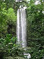 Jurong Falls
 -
 Lory Loft
 -
 Lory Loft
 -
 Lory Loft
 -
 Pelican Cove
 -
 Wetlands Waterfalls
 -
 Entrance
 -
 Entrance
 -
 Entrance
 -
 Entrance
 -
 Entrance
 -
 Entrance
 -
 Entrance
 -
 Entrance
 -
 African Wetlands
 -
 African Wetlands
 -
 African Wetlands
 -
 African Wetlands
 -
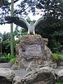 Eagle statue
 -
 Photography with birds
 -
 Pools Amphitheatre
 -
 Lory Loft
 -
 Lory Loft
 -
 Lory Loft
 -
 Lory Loft
 -
 Lory Loft


Jurong Hill edit


Jurong Industrial Estate edit

