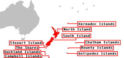
| Map showing the major outlying islands of New Zealand
|
|
| Island group (alternate name) |
Map |
Highest peak (m) |
Location of
main island
|
| North of the North Island
|
| Kermadec Islands (Rangitāhua) |
33.60 |
Moumoukai Peak (516) |
29°16′S 177°55′W / 29.267°S 177.917°W / -29.267; -177.917 (Kermadec Islands)
|
| Three Kings Islands (Manawatāwhi, Ngā Motu Karaka) |
 |
(Great Island) (295) |
34°09′S 172°08′E / 34.150°S 172.133°E / -34.150; 172.133 (Three Kings Islands)
|
| East of the South Island
|
| Chatham Islands (Rēkohu, Wharekauri) |
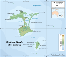 |
(Chatham Island) (299) |
43°54′S 176°32′W / 43.900°S 176.533°W / -43.900; -176.533 (Chatham Islands)
|
| South of the South Island
|
| Solander Islands (Hautere) |
 |
(Solander Island) (330) |
46°34′S 166°53′E / 46.567°S 166.883°E / -46.567; 166.883 (Solander Islands)
|
| New Zealand Subantarctic Islands
|
| Bounty Islands |
 |
(Funnel Island) (73) |
47°46′S 179°02′E / 47.767°S 179.033°E / -47.767; 179.033 (Bounty Islands)
|
| Snares Islands (Tini Heke) |
 |
(North East Island) (130) |
48°01′S 166°32′E / 48.017°S 166.533°E / -48.017; 166.533 (The Snares)
|
| Antipodes Islands |
 |
Mount Galloway (366) |
49°41′S 178°48′E / 49.683°S 178.800°E / -49.683; 178.800
|
| Auckland Islands (Motu Maha, Maungahuka) |
 |
Mount Dick (705) |
50°42′S 166°05′E / 50.700°S 166.083°E / -50.700; 166.083 (Auckland Islands)
|
| Campbell Islands (Motu Ihupuku) |
 |
Mount Honey (558) |
52°32′S 169°09′E / 52.533°S 169.150°E / -52.533; 169.150 (Campbell Islands)
|


