| Category 4 major hurricane (SSHWS/NWS) | |
 Hurricane Fabio at peak intensity | |
| Formed | July 28, 1988 |
|---|---|
| Dissipated | August 9, 1988 |
| Highest winds | 1-minute sustained: 140 mph (220 km/h) |
| Lowest pressure | 943 mbar (hPa); 27.85 inHg |
| Fatalities | 0 |
| Damage | ≤ $1,000 (1988 USD) |
| Areas affected | Hawaii |
| Part of the 1988 Pacific hurricane season | |
Hurricane Fabio was a strong Category 4 hurricane that formed during the near-normal 1988 Pacific hurricane season. Although it did not make landfall, it was one of the seven tropical cyclones to have a major impact on land during the season and one of the three tropical cyclones to affect Hawaii during the season, the others being Hurricane Uleki and Tropical Storm Gilma. The sixth named storm, second hurricane and first major hurricane of the 1988 Pacific hurricane season, it formed from a well-organized ITCZ disturbance with deep convection organized further over the northeastern Pacific Ocean on July 28.[1][2] It developed into a tropical depression later that day, while 1,000 miles (1,600 km) southwest of the southern tip of Baja California.[2] The position of Fabio's formation was much further south and west than where most tropical cyclones form during the same time period.[1] The depression moved westward while gradually strengthening and it developed into Tropical Storm Fabio on July 29. It intensified further over the next few days and it intensified into a hurricane on July 31. The system increased its speed as it steadily strengthened further. A trough turned the storm west-northwestward on August 3. Satellite estimates indicated that Fabio reached its maximum intensity later on August 3, with a well-defined eye with very deep convection surrounding it. The Central Pacific Hurricane Center issued a tropical storm watch for the Big Island on August 4, due to the threatening west-northwest turn towards it. However, the retreat of a trough later turned Fabio back to the west and the CPHC discontinued the tropical storm watch on August 5.[2] Fabio's good upper-level conditions later weakened and began to lose its convection over cooler waters.[1] Fabio quickly weakened and it weakened into a tropical storm again later on August 5, and back to a depression on August 6. The depression turned west-northwestward again on August 8, but Fabio dissipated on August 9.[2] As the cyclone moved near the Hawaiian islands, heavy rainfall fell across the chain, peaking at 18.75 inches (476 mm) near Pāpa'ikou on the island of Hawaii.[3]
Meteorological history
edit
Tropical storm (39–73 mph, 63–118 km/h)
Category 1 (74–95 mph, 119–153 km/h)
Category 2 (96–110 mph, 154–177 km/h)
Category 3 (111–129 mph, 178–208 km/h)
Category 4 (130–156 mph, 209–251 km/h)
Category 5 (≥157 mph, ≥252 km/h)
Unknown
.JPG)
A well-organized tropical disturbance with deep convection organized further over the northeastern Pacific Ocean on July 28. [1][2] It developed into a tropical depression later that day, while 1,000 miles (1,600 km) southwest of the southern tip of Baja California. The position of Fabio's formation was much further south and west than where most tropical cyclones form during the same time period. The depression moved westward while gradually strengthening and it developed into a tropical storm on July 29, given the name Fabio. It rapidly intensified further over the next few days and it intensified into a hurricane on July 31.[4]
.JPG)
Hurricane Fabio crossed into the Central Pacific Hurricane Center's area of responsibility near 13°N, 140°W, on August 2 as an intensifying hurricane with maximum sustained winds estimated at 100 mph (155 mph). Fabio was one of five tropical cyclones that formed in an active east/west trough of low pressure between Hawaii and the Central American coast during the last days of July. Fabio intensified farther south than most tropical cyclones of the "midseason" variety do. It was in a potentially very dangerous location climatologically with respect to Hawaii as it spun up to a very intense hurricane with winds estimated at 140 mph (220 km/h) at 031200Z near 14°N, 144°W. This proved to be the peak intensity as conditions in the upper flow became less favorable and began to make their presence felt on the system. These unfavorable conditions included excessive vertical wind shear and, as seen in the satellite water vapor imagery, a cold and dry environment aloft within a trough in the upper atmosphere. The eye was also very well-defined. The system increased its speed as it steadily strengthened further. A trough turned the storm west-northwestward on August 3. [4]
Air Force reconnaissance aircraft flew into the hurricane at 040000Z and found its center near 17°N, 145°W. Maximum observed surface winds were estimated to be 110 mph (175 km/h). Fabio, at this time, was moving steadily toward the Hawaiian Islands and a tropical storm watch was subsequently issued for the Big Island of Hawaii. The watch remained in effect for about 24 hours and was canceled at 050300Z. It was now a rapidly weakening cyclone and was veering on a course that took it westward well south of the Big Island. The center of the system passed about 210 miles (320 kilometers) south of South Point at 061200Z as a tropical depression with winds estimated at 35 mph (55 km/h).[4]
Some high surf was reported along the black sand beaches on the southeast coast of the Big Island. Some heavy showers with rainfall amounts ranging between 12 and 18 inches fell near Hilo as Fabio passed to the south and southwest. Minor flooding and some road closures from high water were reported in the Hilo area the evening of August 6.[4]
Satellite pictures indicated a hint of strengthening as Fabio passed to the southwest of the Islands on August 7 and August 8 along a track that was briefly bending northward. The outer fringes of the depression interacted with an upper level trough to cause some heavy showers over the island of Kauai on the 8th. Fabio quickly weakened to depression on August 6. The depression turned west-northwestward again on August 8, but Fabio became an extratropical cyclone on August 9. The remnants of Hurricane Fabio were tracked for several more days and could be seen crossing the International Dateline near 22°N at 121800Z.[4] Fabio did not make landfall.
Preparations
editThe Central Pacific Hurricane Center posted a high surf advisory and issued tropical storm watches as Fabio approached the islands. Flash flood watches were also remained in effect for the Hawaii island chains. Civil Defense workers advised residents of the island of Oahu to stock up on canned goods, water, batteries and other provisions. Civil Defense observers also watched for surf generated by Fabio.[5]
Impact
edit| Precipitation | Storm | Location | Ref. | ||
|---|---|---|---|---|---|
| Rank | mm | in | |||
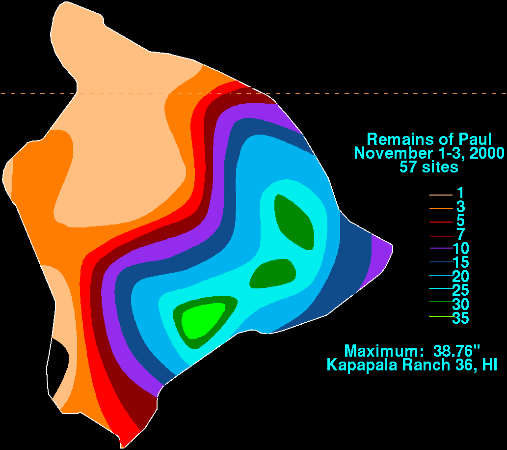
| 1 | 1473 | 58.00 | Lane 2018 | Kahūnā Falls, Hawaii | [6] |
| 2 | 1321 | 52.00 | Hiki 1950 | Kanalohuluhulu Ranger Station | [7] |
| 3 | 985 | 38.76 | Paul 2000 | Kapapala Ranch 36 | [8] |
| 4 | 635 | 25.00 | Maggie 1970 | Various stations | [9] |
| 5 | 519 | 20.42 | Nina 1957 | Wainiha | [10] |
| 6 | 516 | 20.33 | Iwa 1982 | Intake Wainiha 1086 | [3] |
| 7 | 476 | 18.75 | Fabio 1988 | Papaikou Mauka 140.1 | [3] |
| 8 | 387 | 15.25 | Iselle 2014 | Kulani NWR | [11] |
| 9 | 381 | 15.00 | One-C 1994 | Waiākea-Uka, Piihonua | [12] |
| 10 | 372 | 14.63 | Felicia 2009 | Oahu Forest NWR | [13] |
Hurricane Fabio whipped up some very high yet potentially dangerous waves before it was downgraded to tropical storm status as it turns away from the Hawaiian Island chains. Fabio some light to potentially torrential rain and some cloudiness to the southern tip of the Hawaiian Island chain.[14]Rain was extremely torrential, and caused minor flooding to the island chains. The highest total was 18.75 inches (476 millimeters)
See also
editReferences
edit- ^ a b c d Gerrish, Harold P.; Mayfield, Max (1989). "Eastern North Pacific Tropical Cyclones of 1988" (PDF). Monthly Weather Review. 117 (10): 2266. doi:10.1175/1520-0493(1989)117<2266:ENPTCO>2.0.CO;2. ISSN 1520-0493. Retrieved 2012-01-28.
{{cite journal}}: Check date values in:|year=/|date=mismatch (help) - ^ a b c d e BMM (1988). "Tropical Storm Fabio Prelim 1". National Hurricane Center. Retrieved 2007-09-28.
- ^ a b c Roth, David M. (January 3, 2023). "Tropical Cyclone Point Maxima". Tropical Cyclone Rainfall Data. United States Weather Prediction Center. Retrieved January 6, 2023.
 This article incorporates text from this source, which is in the public domain.
- ^ a b c d e "1988 Central Pacific Hurricane Season". National Oceanic and Atmospheric Administration. Retrieved 01-28-12.
{{cite web}}: Check date values in:|accessdate=(help) - ^ "Hawaii Prepares for Approaching Hurricane". Victoria Advocate. August 5, 1988. Retrieved 1-29-12.
{{cite news}}: Check date values in:|accessdate=(help) - ^ David Roth (2019). "Hurricane Lane - August 22-27, 2018". Weather Prediction Center. Archived from the original on October 31, 2020. Retrieved July 24, 2019.
- ^ Central Pacific Hurricane Center. Tropical Cyclones During the Years 1900-1952 (Report). United States National Oceanic and Atmospheric Administration's National Weather Service. Archived from the original on April 19, 2019. Retrieved January 26, 2007.
- ^ Roth, David M.; Hydrometeorological Prediction Center. "Remains of Paul". Tropical Cyclone Point Maxima (GIF). United States National Oceanic and Atmospheric Administration's National Weather Service. Archived from the original on April 19, 2019. Retrieved December 28, 2007.
- ^ Central Pacific Hurricane Center. The 1970 Central Pacific Tropical Cyclone Season (PDF) (Report). United States National Oceanic and Atmospheric Administration's National Weather Service. Retrieved December 28, 2007.
- ^ Central Pacific Hurricane Center. The 1957 Central Pacific Tropical Cyclone Season (PDF) (Report). United States National Oceanic and Atmospheric Administration's National Weather Service. Retrieved November 28, 2007.
- ^ "Iselle Brought Heavy Rainfall and Flooding to Hawaii". National Weather Service Office in Honolulu, Hawaii. National Oceanic and Atmospheric Administration. August 10, 2014. Archived from the original on August 12, 2014. Retrieved August 10, 2014.
- ^ Central Pacific Hurricane Center. The 1994 Central Pacific Tropical Cyclone Season (PDF) (NOAA Technical Memorandum NWSTM PR-41). United States National Oceanic and Atmospheric Administration's National Weather Service. Retrieved November 28, 2007.
- ^ Kimberlain, Todd B; Wroe Derek; Knabb, Richard D; National Hurricane Center; Central Pacific Hurricane Center (January 10, 2010). Hurricane Felicia (PDF) (Tropical Cyclone Report). United States National Oceanic and Atmospheric Administration's National Weather Service. p. 3. Retrieved May 13, 2012.
- ^ "Hurricane produces waves and rain". Orlando Sentinel. August 6, 1988. Retrieved 12-01-29.