Halifax River edit
{{Geobox|River}}
Article: edit
The Halifax River is part of the Atlantic Intracoastal Waterway, located in northeast Volusia County, Florida. The waterway was originally known as the North Mosquito River, but was renamed after George Montagu-Dunk, 2nd Earl of Halifax, during the British occupation of Florida (1763-1784). [1] [2]
Geography edit
The Halifax River originates at Tomoka Bay, at the confluence of the Tomoka River, Bulow Creek, and Halifax Creek, adjoining Tomoka State Park. The Halifax River's drainage basin (or catchment) includes most of eastern Volusia County, which includes the flow from the Tomoka River and Halifax Creek. The total area covered is 1008.3 km². Water flows south for a distance of about 25 miles (40 km). The Halifax River merges with Spruce Creek and the Mosquito Lagoon just before it connects to the Atlantic Ocean via the Ponce de León Inlet. [3]
The Halifax River divides the cities of Ormond Beach, and Daytona Beach. It also runs next to the Jackie Robinson Ballpark on City Island and the Ponce de Leon Inlet Light.
Cities along the river edit
The Halifax River runs through 6 cities and 1 town, and was used to define portions of these cities' borders. The middle of the riverbed at the time the borders were established was the line to define the borders between cities. The cities below have either historic significance or cultural lore connecting them to the Halifax River. They are ordered from the beginning of the river to its end.
- Ormond Beach, Florida - Named after James Ormond, an early settler who arrived in 1807 and took a Spanish land grant. The area was chosen in 1873 by the Corbin Lock Company of New Britain, Connecticut, as a winter haven for their employees. Most of the early settlers were also from Connecticut. The Town of Ormond-By-The-Halifax was incorporated on April 22, 1880.
- Holly Hill, Florida
- Daytona Beach, Florida - Named after Mathias Day of Mansfield, Ohio, who bought x acres of land on the Halifax River in 1870, and developed the land into a settlement. Many of the early settlers were also from Ohio. The town of Daytona was incorporated on x 1876. 50 years later, in 1926, the separate towns of Daytona, Daytona Beach, and Seabreeze merged into the present City of Daytona Beach.
- South Daytona, Florida - Originally known as Blake, located entirely on the mainland south of Daytona Beach, this community was settled circa 1886 and was granted a Post Office in 1887. Blake remained unincorporated until 1926, when the new consolidated Daytona Beach annexed it. The residents decided to fight annexation in the courts, until they were able to form their own city in 1938. The small community incorporated as the City of South Daytona, thus becoming another namesake of Mathias Day.
- Daytona Beach Shores, Florida - This relatively new, small community is located entirely on the beach peninsula, south of Daytona Beach. The community was formed in 1960 by a group of moteliers who called themselves 2,000 Cottages. The City incorporated in 1967 as Daytona Beach Shores, becoming another namesake of Mathias Day. Commonly called "The Shores" by local residents to avoid confusion.
- Port Orange, Florida
- Ponce Inlet, Florida
Bridge crossings edit
There are currently six bridges along the river, including two bascule bridges. They are ordered from the source to the mouth.
- Granada Bridge (SR 40) - The first bridge to cross the Halifax River opened here in 1887, connecting two parts of Ormond Beach, Florida, mainland to the beach peninsula. A later bridge, the Rockefeller Memorial Bridge, a bascule bridge, opened on March 2, 1954. This was replaced by the present high clearance bridge in 1983. [4]
- Seabreeze Bridge (SR 430) - The first Seabreeze Bridge was built in 1902, connecting Ocean Blvd. in Seabreeze to Mason Ave. in Daytona on the mainland. The bridge was later sold and abandoned. It was rebuilt in 1922. A two-lane bascule bridge was opened in 1979 to replace the older bridge. A pair of high clearance bridges were built to replace the drawbridge in 1997. The eastbound bridge connects with Seabreeze Blvd., and the westbound span connects with Oakridge Blvd. [5]
- Main Street Bridge (CR 4040) - The first bridge at this location was opened in 1888. The bridge connected Fairview Avenue from mainland Daytona to Seabreeze Avenue (named Main Street today) in old Daytona Beach (two separate cities at the time). In 1959, a bascule bridge was constructed as a replacement. There are plans to replace this drawbridge with a high span in the near future. [5]
- Broadway Bridge (US 92) - In 1947, the Broadway Bascule Bridge was built, connecting Volusia Avenue on the Mainland to Broadway Avenue on the beach peninsula. [6] In 2001, a new high-span Broadway Bridge was dedicated to replace the old drawbridge. The new bridge is more famous for its flair than its purpose; Mosaics of manatees, dolphins and other wildlife native to Florida give the bridge some tourist appeal.
- Veterans Memorial Bridge (CR 4050) - The "South Bridge" from old Daytona near City Island to old Daytona Beach on the peninsula was built in 1899 with assistance from Henry M. Flagler. The bridge connected Orange Avenue from the Mainland to Silver Beach Avenue on the Peninsula. A replacement bascule bridge was constructed in 1954, and was renamed the Veterans Memorial Bridge in 1959. There are plans to replace this drawbridge with a high span in the near future. [5]
- Port Orange Causeway (SR A1A) - Commonly called the Port Orange Bridge or the Dunlawton Avenue Bridge, this bridge connects the mainland city of Port Orange, Florida with the beach peninsula. The first one at this location was built in 1906, made of sable palm pilings and pine bridge timbers; The bridge was washed away by a hurricane in 1932. A wooden toll bascule bridge was built here in 1951. The drawbridge was replaced in 1990 by a new high bridge which presently spans the river. The Florida State Legislature designated the new bridge as the Congressman William V. Chappel Jr. Memorial Bridge. [7]
History edit
Native Americans edit
The area of the Halifax River was first settled about 7,000 years ago, by Native Americans who were the ancestors of tribes such as the Timucua Indians. The natives lived on fish and and oysters, leaving shell mounds on both sides of the Halifax River. Most of the shell mounds were used by later settlers to build roads, but a few remain in the area, preserved as historical sites, such as Green Mound, Nocoroco, Ormond Mound, and Spruce Creek Mound Complex. The natives were likely part of the St. Johns culture. [8]
European exploration edit
First Spanish occupation 1513-1763 edit
After Juan Ponce de León "discovered" Florida in April 1513, and Pedro Menéndez de Avilés established St. Augustine in 1565, the Spanish continued to explore the region. In 1569 Captain Antonio de Prado first explored the area around Ponce de Leon Inlet (which he named los Mosquitos, due to the large number of gnats that inhabited the area), and mentioned Nocoroco in his report to the King of Spain, noting that the village was located between two rivers (now known as Tomoka and Halifax). In 1605, Spanish explorer Alvaro Mexia visited and mapped the Halifax River area (named North Mosquito River on his map), noting the native villages of Nocoroco, Cacaroy, Cicale, and Caparaca in his report. [9] [10]
The Spanish brought in Franciscan friars and established Catholic Missions in Florida, in an attempt to convert the natives to Christianity. At their peak, there were 44 such Spanish missions in Florida, and some of them may have been in the Halifax River area. The Spanish also recruited the natives to grow food on primitive farms. However, epidemics of Yellow Fever in 1649, Smallpox in 1650, and Measles in 1659 decimated both the Indian and Spanish population in Florida. Several Indian revolts also decimated the population furthur. By the time Spain ceded Florida to the British in 1763, they had little progress to show for their efforts in the colony and Florida was left as a "hollow shell", practically devoid of population when the Spanish evacuated. [10]
British occupation 1763-1783 edit
Spain ceded Florida to the British in 1763, in exchange for Cuba, at the end of the Seven Years War/French and Indian War. Britain then divided the territory into East Florida and West Florida, and gave out many land grants to encourage settlers. During the survey of these land grants, the Halifax River received its name in honor of Lord Halifax, who was the British President of the Board of Trade. The British Council of East Florida made 576 grants on family right totaling more than 210,000 acres, and 114 grants, totaling 1,443,000 acres, by the approval of the King. After the American Revolution began, Florida became the destination for loyalists from the southern colonies, who were offered land free of taxes or levies for ten years. Colonists that settled in the Halifax River area named their colony Halifax City, which was located near present-day Allandale in Port Orange. [11] [12]
It was during the British occupation when Dr. Andrew Turnbull created the notorious New Smyrna colony, just to the south of the Halifax River, in 1768. The New Smyrna colonists complained about mistreatment during their indentured servitude, and the British Governor in St. Augustine eventually allowed them to leave.
Second Spanish occupation 1783-1821 edit
The Spanish joined with the French on the Colonial side, against the British during the American Revolution. After the British loss, they surrendered Florida to Spain in exchange for the Bahamas in the Treaty of Paris (1783). According to the terms of the treaty, the British were obligated to evacuate their colonial subjects; however, Spain allowed any colonists to stay, provided they agreed to swear allegiance to the Spanish Kingdom and convert to Catholicism.
During this occupation period, the Spanish made three large land grants in the Halifax River area, one of which went to James Ormond, a Scottish sea captain. Ormond transported Fransiscan friars to Florida for the Spanish, who gave him the 2,000 acre grant in 1807 as compensation. Two other Spanish land grants (roughly encompassing Daytona Beach and Port Orange) went to absentee landlords, and the areas remained undeveloped.
American period edit
Seminole Wars edit
During the second half of the 18th century, a group of Creek Indians broke away from the tribe and moved into Florida. This group became known as the Seminole Indians. The Seminoles had relatively good relations with the British and Spanish colonial governments; however, they had hostilities with the Americans. Groups of Seminoles apparently carried out raids into neighboring Georgia and retreat back to Florida for safety. These raids eventually led to American military action, led by General Andrew Jackson. Spain sold Florida to the United States in 1821, following the First Seminole War.
Second Seminole War edit
-
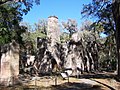 Bulow Plantation Sugar Mill Ruins
 -
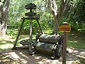 Samuel Williams Plantation Sugar Mill Ruins
 -
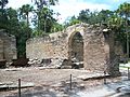
 Dunn-Lawton Plantation Sugar Mill Ruins
 -
 New Smyrna Beach Sugar Mill Ruins


Third Seminole War edit
http://www.dejaelaine.com/plantations4.html
Spain remained in possession of Florida from 1783 until 1821, when it became a United States territory. Some of the earliest settlers to the area included James and George Anderson, who came to Ormond with a Spanishland grant and took over what had been Mount Oswald. Loop road John Anderson Drive is named after their family. Captain James Ormond received a 2,000-acre land grant that he called Damietta Plantation. James Ormond II died in 1829 and is buried in Ormond Tomb Park located on Old Dixie Highway. A landmark of the second Spanish period is located in the vicinity of Pine Tree Drive. What was once the Addison Land Grantwas later sold in part to the McCrae brothers. This landmark, known as the McCrae Plantation Ruins and Addison Blockhouse, are important examples of 19th century plantation architecture. This plantation, like many in the area, was destroyed during the Second Seminole War. The effective reprisals of the Seminole Indians in 1835-36 laid waste to the plantation economy in this part of the state, from which it never recovered. During the course of the next fifty years, these lands lay dormant allowing nature to take its course. In the 1870’s, a new wave of settlers arrived, including a group employed by the Corbin Lock Company of New Britain, Connecticut, who named the area New Britain. In 1876 Chauncey A. Bacon, an architect and Civil War veteran from New Britain, Connecticut, purchased 172 acres in present day Ormond-By-The-Sea andnamed it the Number Nine Plantation. Mrs. Bacon became the first teacher in the colony of New Britain, present day Ormond Beach. In her book Ormond-On-The-Halifax, Alice Strickland describes the site: “The land was covered with a dense, tangled forest of palmettos, scrub oaks, and pine trees which Bacon cleared out with axe and grub hoe. The Bacon’s first home was a palmetto cabin, but later Bacon built a small, two storyhouse with a large coquina rock fireplace on top of the Indian shell mound. Eventually this house became the ‘jelly house’ where Jennie Bacon, and their son, Earl, made delicious jams, jellies, and preserves that were sold on the property and also shipped to all parts of the country.” The Bacons constructed a third home, whichstill stands on John Anderson Drive, from salvagedmahogany logs that washed ashore from the wreck of the City of Vera Cruz. The Number Nine was a favorite picnic ground for the early settlers of New Britain withpicnickers and other guests traveling by boat on the Halifax River since no roads along the riverfront on the east side of the Halifax River existed. The Bostrombrothers came to what is now called Riverside Drive andbuilt a fine home called Bosarve, which means “Home Place” in Swedish. Like the Bacons, the Bostroms built three homes altogether on the same site; the first was a palmetto shack, then a two-story frame house and eventually a third home with some of the lumber coming from Jacksonville and some salvaged from ship wrecks. Alice Strickland’s book describes the shingles as being homemade and “the bricks for the chimney were pilfered from old plantation ruins.” Bosarve, which is still filled with magnificent old oak trees, was torndown in recent years and a modern home now occupies the site.
19th century edit
Steamboat commerce edit
Steamboat transport remained a viable industry (both in terms of passengers and freight) until the end of the first decade of the 20th century. Among the several Mississippi River system steamboat companies was the noted Anchor Line, which from 1859 to 1898 operated a luxurious fleet of steamers between St. Louis and New Orleans.
Civil War edit
During the American Civil War, the Union initially ignored the Halifax River area, and focused on blocking Florida's main ports in Jacksonville and Tampa.
20th century edit
Prohibition edit
Notorious rum-runner William S. McCoy was born in Syracuse, New York in 1877 and moved to Holly Hill, on the Halifax River around 1900. Bill and his brother Ben operated a motor boat service and a boat yard in Holly Hill and Jacksonville. By 1918, having constructed vessels for millionaire customers that included Andrew Carnegie and the Vanderbilts among others, McCoy earned a reputation for being skilled yacht builder.[13] [14]
During Prohibition (1920-33), the McCoy brothers fell on hard times. Needing money, the two brothers made a decision to go into rum-running. They sold the assets of their business, traveled to Gloucester, Massachusetts, and bought the schooner Henry L. Marshall. McCoy then began to smuggle whisky into the U.S., traveling from Nassau and Bimini in the Bahamas to the east coast of the United States, spending most time dealing on "Rum row" off Long Island. After a few successful trips smuggling liquor off the coast of the United States, Bill McCoy had enough money to buy the schooner Arethusa. Placing the schooner under British registry in order to avoid being subjected to U.S. law, Bill renamed the vessel Tomoka (after the name of the Tomoka River that flows into the Halifax).
McCoy made a number of successful trips aboard the Tomoka, and - along with the Henry L. Marshall and up to five other vessels - became a household name through his smuggling activities. Capt. McCoy mostly hauled Rye, Irish and Canadian whiskey as well as other fine liquors and wines. McCoy's legend grew as his quality liquor and fair-dealing perpetuated the phrase: "it's the real McCoy."[15][14][16]
McCoy also became an enemy of the U.S. Government and organized crime. When the Coast Guard discovered McCoy, he established the system of anchoring large ships off the coast in international waters and selling liquor to smaller ships that transferred it to the shore. McCoy also smuggled liquor and spirits from the French islands of Saint-Pierre and Miquelon located south of Newfoundland.
Capture and arraignment edit
On November 23, 1923, the U.S. Coast Guard Cutter Seneca, had orders to capture Bill McCoy and the Tomoka, even if in international waters. A boarding party boarded the Tomoka, but McCoy refused to surrender. The Tomoka tried to flee, but the Seneca placed a shell just off the hull, and Bill McCoy's days as a rum-runner were over. The New York Times article that reported on the capture and arraignment of McCoy described the incident:
The report to Collector Elting showed that the Tomaka was first boarded by Lieut. Commander Perkins of the Coast Guard cutter Seneca, who ordered the crew keep silent. The bow of the schooner then was turned out to sea, and when the commander of the cutter observed the movement, he sent a shot across the bow of the Tomaka. She returned the fire with a machine gun set up on her forward deck. The machine gunners ran to cover when the shells of the Seneca began to fall so close to their mark that they kicked the spray over the Tomaka's deck. [17]
McCoy described the chase that led to his capture:
When the Tomoka was boarded under cover of the Seneca's guns, I immediately set sail and ran away with the boarding party - one lieutenant, one bos'n and thirteen seamen - and only upon their pleas did I heave to and put them back on the Seneca. The damned radio was too severe a handicap for me. I surrendered after the Seneca had fired four-inch shells at me.[18]
When asked what defense he planned to make at the hearing before the trial, McCoy introduced the details of his operations by replying:
I have no tale of woe to tell you. I was outside the three-mile limit, selling whisky, and good whisky, to anyone and everyone who wanted to buy.[19]
Instead of a long drawn out trial, Bill McCoy pleaded guilty and spent nine months in a New Jersey jail. He returned to Florida and invested his money in real estate. He and his brother continued the boat building business and frequently traveled up and down the coast.
World War II edit
The Halifax River's main activity during World War II involved the Daytona Beach Boat Works, located just south of City Island. Originally designed to build yachts, the boatyard was converted to Navy construction. During the war, the boatyard produced nineteen P.C. class 110-foot subchasers; six 104-foot aircraft rescue ships; and a number of 40-foot motor launches, known as "Liberty boats." The boatyard was awarded four Army-Navy ‘E’ Awards for Excellence in Production, and was the site for many boat launching ceremonies. The boatyard also provided employment for 375 people in the area during the war. [20]
Recreation edit
Boating edit
Recreational boating is a popular activity, and there are several Marinas located throughout the Halifax River:
The island has four yacht clubs, all situated on the Eastchester Bay side of the island. They are, from north to south, the Harlem Yacht Club[1], Stuyvesant Yacht Club[2], City Island Yacht Club[3], and Morris Yacht and Beach Club[4]. The Touring Kayak Club is on the west side of the island. There are two active sail lofts (Ulmer-Kolius and Doyle). The island also has several commercial marinas. The island has what are called "special anchorages" where boats of all sizes are freely moored or anchored, and there are many docks with boat slips for mooring boats in a secure and restricted way. There are also many large piers around the island that can receive large ships.
Recreational boating is a popular activity, and there are several Marinas located throughout the Halifax River:
- Aquamarina Daytona, 645 S. Beach Street, Daytona Beach [5]
- Loggerhead Club & Marina, 721 Ballough Rd, Daytona Beach [6]
- Sunset Harbor Yacht Club, 861 Ballough Road, Daytona Beach [7]
- Halifax Harbor Marina, 450 Basin Street, Daytona Beach [8]
- Halifax River Yacht Club, 331 South Beach St, Daytona Beach [9]
- Halifax Sailing Association, 15 Fremont Ct, Daytona Beach [10]
- Marina Port Orange, 3537 Halifax Dr, Port Orange
- Adventure Yacht Harbor, 3948 S Peninsula Dr, Port Orange [11]
- Inlet Harbor Marina & Restaurant, 133 Inlet Harbor Rd, Ponce Inlet [12]
- Lighthouse Boatyard & Marina, 4958 S Peninsula Dr, Ponce Inlet [13]
Fishing edit
Fishing is another popular activity in the Halifax River. Fishing is allowed from boats, the banks of the river, or from any of the bridges crossing the waterway. Some of the species that can be found include: Catfish, Flounder, Sheepshead, Crappie, Tarpon, Snook, and Red snapper. [21]
Wildlife Viewing edit
The Halifax River supports a diverse community of waterfowl, wading birds, fish, and other wildlife. The river and several of its tributaries (Tomoka River, Strickland, Thomson and Dodson Creek) are designated as a Manatee Sanctuary. Other rare species that inhabit the river basin include the wood stork, bald eagle, and Atlantic salt marsh snake. Numerous other birds can be viewed in the general area of the Halifax River Basin.
The Halifax is a natural bird reserve and the feathered creatures seem to realize it. Wild ducks of all kinds swim along almost unconsciously and will sometimes permit a boat to approach near. It is great sport to watch them swimming along and feeding in their own natural way. Many other birds will be seen among which the most conspicuous are doubtless the several species of herons. One or more of them is almost constantly in sight. Like most fisher birds the herons are generally alone seeming unwilling to share with others even of the same family, revealing a rather unsocial nature.
edit
Intercoastal Waterway edit
Prior to 1913, navigation channels and canals in Florida were maintained chiefly by private enterprize. In 1882 the Florida East Coast Line Canal and Transportation Co. was organized to develop a waterway from Jacksonville to Biscayne Bay by connecting with canals the St Johns, Matanzas, and Halifax rivers, Mosquito Lagoon, Indian river, Lake Worth, Hillsboro river, New river, and Snake Creek; in 1908 this vast undertaking was completed.
This section incorporates text from a publication now in the public domain: Encyclopædia Britannica (11th ed.). 1911. {{cite encyclopedia}}: Missing or empty |title= (help)
The Rivers and Harbors Act of 1927, passed by Congress, authorized the Atlantic Intracoastal Waterway, using the route planned out by the Jacksonville District of the U.S. Army Corps Of Engineers. The Waterway was valuable during World War II, after German submarines sank numerous merchant ships off the East Coast. The Corps continues to maintain the navigation channel today, conducting dredgings as needed. [22]
Late 20th century edit
21st century edit
Arts and culture edit
Literature edit
Music edit
Popular culture edit
Wildlife Gallery edit
-
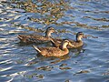 Mallard Ducks swim in the Halifax River near Daytona Beach.
 -
 A hungry Little Blue Heron feasts on a fish in the Halifax River.
 -
 American White Ibis' hunt for food on the bank of the Halifax River.
 -
 A Great Blue Heron near the west bank of the Halifax River.
 -
 A Great Egret wades near the west bank of the Halifax River.
 -
 A Double Crested Cormorant rests on an abandoned piling.
 -
 A Brosn Pelican rests on a navigation marker near Ormond Beach.
 -
 Birds gather at the Port Orange Wildlife Sanctuary.


See also edit
References edit
- ^ Hometown News: East Volusia has rich history
- ^ The Montague Millennium: George Montagu Dunk, 1716-1771
- ^ "Halifax River Watershed Facts". St. Johns River Water Management District. Retrieved 2008-11-17.
- ^ Ormond Beach Historical Trail
- ^ a b c Gold, Pleasant Daniel (1927). History of Volusia County, Florida. Deland, FL: The E. O. Painter Printing Co.
- ^ Fifth International Bridge Engineering Conference: Tampa, Florida April 3-5 - Page 31 by National Research Council (U.S.). Transportation Research Board - Bridges - 2000
- ^ Cardwell, Harold and Priscilla (2000). Images of America: Port Orange. Arcadia Publishing. ISBN-10: 0738506184.
- ^ True Natives: The Prehistory of Volusia County By Dana Ste. Claire (1992)
- ^ Haunted Daytona Beach: A Ghostly Tour of the World's Most Famous Beach by Dusty Smith (2007)
- ^ a b An Environmental History of Northeast Florida By James J. Miller (1998)
- ^ Loyalists in East Florida 1774-1785, Wilbur H. Siebert, Deland Florida (1929)
- ^ Florida Place Names: Alachua to Zolfo Springs, Allen Morris, (1995)
- ^ John Kobler, Ardent Spirits: The Rise and Fall of Prohibition (New York: Da Capo Press, 1973), p. 258.
- ^ a b Donald L. Canney, "Rum War: The U.S. Coast Guard & Prohibition", at U.S. Coast Guard
- ^ World Wide Words Summary of theories
- ^ John Kobler, Ardent Spirits: The Rise and Fall of Prohibition (New York: Da Capo Press, 1973), p. 257.
- ^ "Sea Rumrunner Held on 2 Liquor Charges," New York Times, ProQuest Historical Newspapers, Nov. 27, 1923, p. 21.
- ^ Philip C. Jessup, "No Reflection Intended," New York Times, ProQuest Historical Newspapers, Nov. 6, 1932, pg. E2.
- ^ "Sea Rumrunner Held on 2 Liquor Charges," New York Times, ProQuest Historical Newspapers, Nov. 27, 1923, p. 21.
- ^ Cite error: The named reference
Centennialwas invoked but never defined (see the help page). - ^ Daytona Beach News Journal Online: Fishing Report
- ^ "Jacksonville District, Setting the Pace" (PDF). U.S. Army Corps of Engineers. Retrieved 2010-08-07.
External links edit
- http://sjr.state.fl.us/archydro/factPages/27010037.html St. Johns River Water Management District: Halifax River Basin Characterization