| This is a Wikipedia user page. This is not an encyclopedia article or the talk page for an encyclopedia article. If you find this page on any site other than Wikipedia, you are viewing a mirror site. Be aware that the page may be outdated and that the user in whose space this page is located may have no personal affiliation with any site other than Wikipedia. The original page is located at https://en.wikipedia.org/wiki/User:ChocolateTrain/Cyclone_image_galleries. |
Welcome to ChocolateTrain's Cyclone image galleries page! This page is where ChocolateTrain uploads a collection of images for each tropical and subtropical cyclone that occurs on Earth. The galleries can be used by other users to compare images easily so they can determine which image to use in an article regarding a particular cyclone. Not all images taken of every cyclone will be shown; rather, only images of the storm near peak intensity will be shown. There will on occasion, however, be images of the storm at other times, such as when they are impacting a particular landmass, rapidly strengthening, weakening, etc. These images are for the purpose of use in the body of articles solely about one particular cyclone, rather than for the main infobox in these articles or in cyclone season articles. Note that the wind speeds displayed on this page are one-minute sustained, unless otherwise stated.
In general, only ChocolateTrain should edit this page. Additionally, this is not a talk page. If you would like to leave ChocolateTrain a message regarding anything on this collection of cyclone image galleries, please feel free to do so on this page's talk page or ChocolateTrain's talk page. He will be happy to respond to your enquiries.
Please enjoy the images! Kind regards, ChocolateTrain.
Atlantic
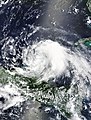
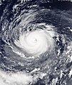
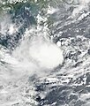
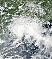
editTropical Storm Franklin
edit- Dates: 6 August 2017 — Present
- Peak winds: 50 knots (95 km/h, 60 mph)
- Main article:
- Season article section: 2017 Atlantic hurricane season § Tropical Storm Franklin
-
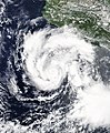
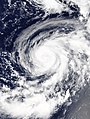
 19:10 UTC, 7 August (Winds: 50 knots)
 -
 16:45 UTC, 8 August (Winds: 40 knots) YUCATAN PENINSULA


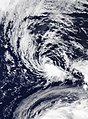
Eastern Pacific
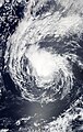
editTropical Storm Greg
edit- Dates: 17 July 2017 — 26 July 2017
- Peak winds: 50 knots (95 km/h, 60 mph)
- Main article:
- Season article section: 2017 Pacific hurricane season § Tropical Storm Greg
-
 18:40 UTC, 21 July (Winds: 50 knots)
 -
 21:45 UTC, 21 July (Winds: 45 knots)
 -
 19:20 UTC, 22 July (Winds: 45 knots)
 -
 21:10 UTC, 22 July (Winds: 45 knots)
 -
 19:10 UTC, 24 July (Winds: 40 knots)


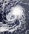
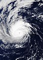
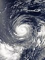
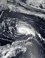
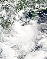
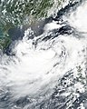
Hurricane Hilary
edit- Dates: 21 July 2017 — 31 July 2017
- Peak winds: 90 knots (165 km/h, 105 mph)
- Main article:
- Season article section: 2017 Pacific hurricane season § Hurricane Hilary
-
 17:30 UTC, 24 July (Winds: 75 knots)
 -
 20:30 UTC, 24 July (Winds: 75 knots)
 -
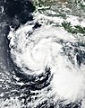
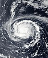
 18:15 UTC, 25 July (Winds: 90 knots)
 -
 20:15 UTC, 25 July (Winds: 90 knots)
 -
 18:00 UTC, 27 July (Winds: 65 knots)


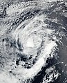
Hurricane Irwin
edit- Dates: 22 July 2017 — 1 August 2017
- Peak winds: 80 knots (150 km/h, 90 mph)
- Main article:
- Season article section: 2017 Pacific hurricane season § Hurricane Irwin
-
 20:35 UTC, 24 July (Winds: 55 knots)
 -
 18:15 UTC, 25 July (Winds: 75 knots)
 -
 21:20 UTC, 25 July (Winds: 75 knots)
 -
 18:55 UTC, 26 July (Winds: 45 knots)
 -
 22:00 UTC, 26 July (Winds: 45 knots)


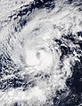
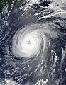
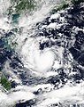
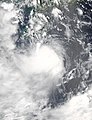
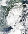
Hurricane Kenneth
edit- Dates: 18 August 2017 — Present
- Peak winds: 115 knots (215 km/h, 130 mph)
- Main article:
- Season article section: 2017 Pacific hurricane season § Hurricane Kenneth
-
 18:52 UTC, 20 August (Winds: 70 knots)
 -
 21:56 UTC, 20 August (Winds: 80 knots)
 -
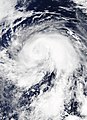
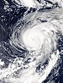
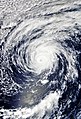 19:34 UTC, 21 August (Winds: 105 knots)


Western Pacific
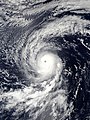
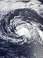
editTyphoon Noru
edit- Dates: 19 July 2017 — Present
- Peak winds: 140 knots (260 km/h, 160 mph)
- Main article: Typhoon Noru (2017)
- Season article section: 2017 Pacific typhoon season § Typhoon Noru
-
 03:25 UTC, 23 July (Winds: 50 knots)
 -
 00:05 UTC, 25 July (Winds: 80 knots)
 -
 03:15 UTC, 25 July (Winds: 80 knots)
 -
 00:45 UTC, 26 July (Winds: 75 knots)
 -
 02:20 UTC, 26 July (Winds: 75 knots)
 -
 03:05 UTC, 27 July (Winds: 65 knots)
 -
 03:45 UTC, 29 July (Winds: 65 knots)
 -
 03:25 UTC, 30 July (Winds: 60 knots)
 -
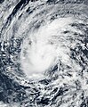
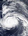
 01:00 UTC, 31 July (Winds: 130 knots)
 -
 04:15 UTC, 31 July (Winds: 130 knots)
 -
 04:05 UTC, 2 August (Winds: 105 knots)
 -
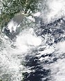
![Nearing mainland (50 km SSW of Yakushima]]](//upload.wikimedia.org/wikipedia/commons/thumb/f/fd/Noru_2017-08-05_0435Z.jpg/91px-Noru_2017-08-05_0435Z.jpg) Nearing mainland (50 km SSW of Yakushima]]
Nearing mainland (50 km SSW of Yakushima]]


![Nearing mainland (50 km SSW of Yakushima]]](/wiki/File:Noru_2017-08-05_0435Z.jpg)
Tropical Storm Kulap
edit- Dates: 19 July 2017 — 26 July 2017
- Peak winds: 45 knots (85 km/h, 50 mph)
- Main article:
- Season article section: 2017 Pacific typhoon season § Tropical Storm Kulap
-
 23:30 UTC, 21 July (Winds: 40 knots)
 -
 01:50 UTC, 23 July (Winds: 35 knots)
 -
 02:00 UTC, 24 July (Winds: 45 knots)
 -
 00:00 UTC, 25 July (Winds: 35 knots)


Tropical Storm Sonca
edit- Dates: 21 July 2017 — 25 July 2017
- Peak winds: 40 knots (75 km/h, 45 mph)
- Main article:
- Season article section: 2017 Pacific typhoon season § Tropical Storm Sonca
-
 02:55 UTC, 22 July (Winds: 25 knots)
 -
 06:00 UTC, 22 July (Winds: 30 knots)
 -
 03:35 UTC, 23 July (Winds: 35 knots)
 -
 05:40 UTC, 23 July (Winds: 35 knots)
 -
 05:45 UTC, 24 July (Winds: 40 knots)
 -
 06:30 UTC, 25 July (Winds: 40 knots)


Tropical Storm Roke
edit- Dates: 21 July 2017 — 23 July 2017
- Peak winds: 35 knots (65 km/h, 40 mph)
- Main article:
- Season article section: 2017 Pacific typhoon season § Tropical Storm Roke
-
 02:50 UTC, 22 July (Winds: 25 knots)
 -
 06:00 UTC, 22 July (Winds: 35 knots)
 -
 05:40 UTC, 23 July (Winds: 30 knots)


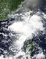
Typhoon Nesat
edit- Dates: 25 July 2017 — 30 July 2017
- Peak winds: 80 knots (150 km/h, 90 mph)
- Main article: Typhoon Nesat (2017)
- Season article section: 2017 Pacific typhoon season § Typhoon Nesat
-
 02:30 UTC, 26 July (Winds: 40 knots)
 -
 05:10 UTC, 30 July (Winds: 40 knots)


Tropical Storm Haitang
edit- Dates: 27 July 2017 — 1 August 2017
- Peak winds: 40 knots (75 km/h, 45 mph)
- Main article:
- Season article section: 2017 Pacific typhoon season § Tropical Storm Haitang
-
 05:25 UTC, 29 July (Winds: 35 knots)
 -
 05:10 UTC, 30 July (Winds: 40 knots)
 -
 02:45 UTC, 31 July (Winds: 35 knots)


Tropical Storm Nalgae
edit- Dates: 31 July 2017 — Present
- Peak winds: 40 knots (75 km/h, 45 mph)
- Main article:
- Season article section: 2017 Pacific typhoon season § Tropical Storm Nalgae
-
 23:45 UTC, 4 August (Winds: 40 knots)
