| Bentayga Rock | |
|---|---|
| Native name Spanish: Roque Bentayga | |
 Bentayga Rock and Tejeda | |
| Type | volcanic plug |
| Location | Tejeda, Grand Canary, Canary Islands, Macaronesia, off the west coast of Africa |
| Nearest city | Tejeda |
| Coordinates | 27°59′28.4208″N 15°38′31.5060″W / 27.991228000°N 15.642085000°W |
| Elevation | 1,404 m (4,606 ft) or 1,412 m (4,633 ft)[1] |
| Formed | ~4M years ago[2] |
| Type | Archaeological site |
| Designated | June 7, 1988[3] |
 Location of Bentayga rock on Grand Canary island | |
Bentayga Rock is one of the particular rocky formations on Grand Canary island, in the province of Las Palmas, Canary islands, Spain.
At its foot was a human settlement with cave houses, silos and burial cavities and what is generally believed to be a ritual place. During the invasion of the island by Europeans in the 16th century it was a fortress that sheltered the ancient Canarians who resisted Spanish attacks.[4][5]
It is listed as a Spanish Property of cultural interest[3] in the biosphere reserve that includes the whole island.[6]
Location and access edit
Located in the municipality of Tejeda at the heart of the island, Bentayga rock stands some 1.7 mile (2.7 km) (on a straight line - 3.6 m. (5.8 km) by the road) east of this village, [7] in the centre part of the caldera de Tejeda ("crater of Tejeda"), a large collapsed volcanic crater. [8] [9] [note 1]
Roque Nublo ("Clouded Rock") is about 4 km to the south-south-east, on the other side of the deep barranco del Chorillo that fringes the south side of the caldera de Tejeda. The cave house village of Artenara [10] [9] is about 4 km to the north-north-west, on the north side of the barranco de Tejeda and the northern edge of the caldera de Tejada.[7][8]
Acusa Seca[11] is about 3 km to the north-east of Bentayga Rock.[8]
The GC-671 road leads to it, starting from the GC-607 to the east - itself starting on the GC-60 that goes from Tejeda to San Fernando and the Playa des Inglés in the south of the island.[7]
Cars must stop at the Interpretation centre. From there a footpath winds up its way to the foot of Bentayga, following an eroded rocky crest and arriving by the east side.
Geology edit
The caldera de Tejeda is a basin created by the collapse of a volcanic crater.[12] Bentayga rock is a volcanic plug made of basalt (a volcanic rock), formed along with the other surrounding peaks[8] some 3.5 to 4 M years ago during the second cycle of volcanic eruptions that formed the island, known as the "Roque Nublo cycle".
For more details on the formation of the island, see Gran Canaria#Geology; on the formation of the collapsed crater of Tejeda, see Tejeda#Geology: ''caldera de Tejeda''.
-
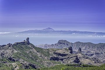
 Caldera de Tejeda: Roque Nublo to the left, Roque Bentayga centre, cliffs of the Andén de Tasarte stretching in between; mount Teide on Tenerife on the horizon to the right

Description edit
Beyond Bentayga Rock itself, the archaeological site includes a number of other features.[5]
At the end of the road that leads to Bentayga, is the Interpretation Centre that was inaugurated on October 26, 2013.[13] From there, a footpath leads to the foot of Bentayga Rock on its eastern side. On that side Bentayga rock is 70 m high.[5] On the way, shortly after the Interpretation Centre, the path passes on the left of the location of the Spanish camp during the conquest (15th century).
As it nears Bentayga, it crosses the defence wall that partly surrounds Bentayga.
Just after the path crosses the defence wall there is a small dwelling, possibly for the use of guards keeping a look out. On the right (north-side) is a rocky crest, with its base crossed over by a tunnel and at its top the controversial almogarén or house. This is reached by a steep path that starts at the end of the defence wall and follows up the fold on the north side of that crest. Half-way up that path are a few granaries. Reaching near the top of that crest with the almogarén or house, the path takes to the left (towards the south), passing through a short tunnel that cuts across the top of the crest. It leads south, closely following the foot of Bentayga. It first reaches a cave dwelling, then the start of the path that leads to the top of Bentayga; it stops shortly after, when it meets the cliff.
Two stations bear calligraphic signs.
Back at the level of the Interpretation Centre, there are two places that gather collections of cave dwellings, and further south three places gathering collections of granaries.[note 2]
At its foot two rock stations with Libyan-Berber alphabetiforms were found.[14]
Bentayga painted : [16]
Ritual place (almogarén) or house? edit

The remains edit
On the top crest near the base of Roque Bentayga on its eastern side, is a structure the use of which is controversial. Its natural base is made of a flat-ish stone surface, elongated in the south-east/north-west direction and sloping somewhat towards the north-west; it is bordered on its north side by two rises in the rock; the north-east rise forms a shallow outcrop south-wise and thus provides a small natural shelter. On this was built... a structure or structures of some sort, that have left enough remains to raise curiosity.
The main space[note 4] is a totally levelled rectangular surface, hand-excavated, that measures approximately 6 x 3,5 meters.
A shallow channel runs inside along the east and south wall remnants of the main space, and other channels cross the floors of the two floor spaces.
In the middle of the main floor has been dug a circular channel about 20 cm deep and 80 cm in diameter. On the east side it receives a channel that collects rainwater coming from the east wall and from the rocky outcrop on the north side. On the west side of this circle (that is, the direction towards which water in the circular channel would run off), the channel joins onto a rectangular hole - the latter having a concave bottom and being slightly deeper than the channel.
There are two holes in the ground about 1 meter away westward of the circular structure in the centre. These holes are about 1 meter apart, and they are centered in relation to the width of the main space.
It is not possible to determine if there was a further space or room on the west side of the main space. There is a smaller space or room on the east side. Its dimensions are about 2.30 x 1.20 metres. Its floor surface is higher than the main room's floor. Its aspect, including the floor, is rougher and looks more eroded than that of the main space.
The two floors were dug in the same agglomerate as Roque Nublo's, their top stratum being augitic basalt of major hardness.
This place used to be called La Cruz de Cho Matías ("Cho Matías's Cross").
Recent history and theories edit
In the 19th century well-known explorers such as René Verneau or Victor Grau-Bassas studied Bentayga and its "almogarén".
Víctor Grau-Bassas (1847-1918), who extensively explored the caldera in the second part of the 19th century, did not see in it any excavated floor. In the 1930's D.J. Wölfel, Austrian philologist, was the first one to interpret the place as an altar for sacrifices. In the 1940's, Sebastián Jiménez Sanchez calls it for the first time "almogaren del Bentayga".[17] In the 1980's Mauro Hernández Perez explored the place again, accompanied by a member of the Comisión de Arqueología del Museo Canario, and described the place but without attributing to it any particular connotation, religious or otherwise. Researchers such as Antonio Tejera Gaspar, Jose Juan Jiménez Gonzalez (adding symbolic sexual connotations to Bentayga),[note 5] Julio Cuenca and Anthony F. Aveni, Ernesto Martin Rodríguez[18], followed the "almogarén" interpretation. The Guide of archaeological Heritage of Gran Canaria ("Guía del Patrimonio Arqueológico de Gran Canaria"), page 343, gives a photo of the so-called almogarén with the description: "curious construction excavated... interpreted as cultual place or almogarén" ("curiosa construcción excavada... interpretada como lugar de culto o almogaren").
Some authors added to it the "solar calendar" theory: César Esteban jointly with Juan Antonio Belmonte and Antonio Aparicio,[19]; student of astrophysics Oswaldo Gonzalez Sanchez; Jose Carlos Gil Carreras in Arqueoastronomía Canaria; Pepe "Cuevas", Javier Velasco and Tomas Correa in the website estodotuyo (site on Heritage assets by the council of Grand Canary); J. Alberto Bachiller Gil;[20] Alfredo Mederos Martin and Gabriel Escribano Cobo;[21] Alfredo Mederos Martin, Vicente Valencia Afonso, Gabriel Escribano Cobo;[22] and numerous web pages. The TV documentary series Canarias en casa, in its piece on Bentayga, mentions the breaking of jars filled with milk as a ritual.
So far most researchers, including those of the Unidad de patrimonio histórico del Cabildo ("Council department of historical heritage"), have given more importance to the theory of "religious and astronomic context" than to the military and defensive aspect that the ancient settlements had and have not taken into account some elements such as those further down here.[5]
On December 10, 2000, a new perspective is presented for the reconstruction of the place: it could have been a normal dwelling but with two successive occupations.[note 6] A first house was built, levelling the floor. Later, a second house was built on the west side of the first house, remodelling and reusing some of the space occupied by the first house.[note 7]
The possibility of two successive dwellings edit
This theory of two successive dwellings (rather than a sacred place of worship) came to light in view of a number of well-made points.
- There is no artificial platforms for cultual use of these dimensions that contain small pans ("cazoletas") and channels, and these platforms are natural - whereas here the ground here has clearly been levelled up against its slope.
- Remodelling parts of a previous dwelling, shelter or silo for it to be part of a other building built later, was a commonly used building adaptation in Grand Canary. Here it merely adapts to the narrowness between a rocky outcrop and the edge of the south cliff.
- The existence of a small room on one side of the main space, such as there is here on the eastern side of the second construction, is a common floor plan for dwellings of those times in Gran Canaria. In fact there usually are at least two smaller side spaces, commonly placed opposite to each other in relation to the main space.
- The carved salient corners of the smaller space or bedroom east-wise, that show little difference with the entrances of the main space.
- There is a good case for interpreting most of the channels in the floor (main space and smaller east room) simply as means to evacuate rainwater; those for the first house were integrated and prolonged in the second house.[note 8]
- The channels that do not participate to this rainwater drainage are 1) those that correspond to anchorages of the doors[note 8] and 2) those that made up a sophisticated home stove in the middle of the floor and in front of the entrance.[5][note 9]
The first house was a smaller building on the eastern side of the present remains, and stood higher on the slope than the second house. Leaning on the same rocky outcrop on the north side that the second and larger house would later use, its walls were rounded in a semi-sphere profile. It had channels dug into the rock floor to evacuate rainwater that, by the way the channels are laid, used to both come in through the eastern wall and percolate along the rocky northern wall. At the threshold there are two small parallel channels and a quadrangular hollow on the right-hand side, part of a shutting system of some sort - possibly a frame or/and door, may be made of wood. At the back of the house, facing the door and near the foot of the rocky outcrop that made the north wall, are some rainwater channels and a cazoleta or "small pan" linked to these chanels; that small pan may have acted as a water flow regulator, collecting the overflow from the channels.[note 7]
The western part of the pavement of the first house corresponds to the most eroded platform, higher and smaller, in the east part of the second house. That platform measuring about 2.30 x 1.20 metres, and it being about half of the first house floor surface, that first house may have measured approximately 3 x 3 meters, with a floor plan roughly quadrangular. Its housing capacity was maximum 3 people.[5]
The second house corresponds to the lowest and largest platform. On its east side it integrated half of the first house by digging half of that first house's floor and turning that space into a small room. That part would have been more damp than the rest of the second house, because that small space receives all the outflow of rainwater coming from the highest part of the rock that the whole structure was built on.
The floor in that small east room is slightly higher than the rest of the second house; it is also rougher, with an uneven surface. This may be due to that as sleeping space it would have been covered with a wood ans stone base to sleep on, as has been found in other ancient dwellings of the island. There is a hole in the left corner of this bedroom, possibly a part of the anchorage of the mentioned bed base.
The dwelling thus went from semi-quadrangular floor plan to a semi-cruciform one. Its housing capacity was about 7 people.
Always the fight has been priority against the interference of the Dampness and the Water, managing them to evacuate her of the inhabitable interiors, by what a system of outlet is added as in the former structure, the same reason facilitated, , and in whose(which) interior at the foot of the next corner exists a hole that could use as well of residues during the outlet, as well as also a small section in the north side that drained the waters to below the paraments of the half west, avoiding the flood of the principal pavement or rectangular lounge, which includes the oven.
Also they repeat themselves, in relation to the ancient structure, the small PARALLEL CHANNELS ON THE edge OF THE DOOR, which in this case they combine on the mentioned channel of outlet. These brands(marks) belong to a system of closuse more sophisticated that the previous one, treats itself(himself,herself) about a small door that it was fitted to pressure. Parallelisms exist with the marks on a plank at the permanent exhibition of The Canary Museum, and that could be the lintel or threshold of a door of a habitat.
Rightly in the exterior(foreign) edge of the threshold of entry one is reduce or step to facilitate the entry or exit to this habitat.
In the same access and before seeing the pavements, it(he,she) arrives at the right in the vertical wall, there exists a CARVED(TOOLED) CHANNEL that might relate to anchorages for supports of scaffolding of a structure or necessary stairs to go down or to rise in view of the difficulty of the access which the vertical wall faces and probably house could belong(concern) to the old woman entered(approached) to the 1 ª house or ancient.
On the left side of the entry of the cave, it(he,she) has excavated a canalillo vierteaguas that they favor the diversion of the water of rain proceeding from the top rock preventing from leaking on this entry. This cave could have been a complement to the refuge in this strategic defensive area and to be the first shelter of the most ancient epoch and probably synchronously with the first quadrangular house.
The stove and derivate traces edit
In houses of those times the fire was always placed in the central part of the main room and opposite to the entry, such as is the case here with the remains of a circular channel dug around a centre part - this being the element that has led many researchers into believing that this was a cultual place.[5]
The circular channel around it, about 20 cm deep and 80 cm in diameter, had a dual function. It activated the ventilation for better combustion of the fire in the centre. It also collected the rain that fell inside through the smoke hole in the roof above; that water would then gather in the lowest part of the collecting system, where we find the small rectangular pan. Scooping the water from there by hand was made easier by the concave bottom.[5]
Such an open fire requires an outlet for the smoke, as will know anyone who has lived with an open fire. Hence there must have been a hole in the roof straight up above the fire place, to serve as a smoke outlet. To note that this unavoidable smoke outlet goes unmentioned in documentaries and absent from the reconstruction of dwellings at the Painted cave archaeological village zone in Galdar, where similar fireplaces have been identified as such. The smoke hole also served as skylight. It may have had a lid, such as the one found in a cruciform house in el Pajar (the Barn) near Arguineguín: there, the fire place was built on a similar principle as here except for it being rectangular. Beside it was found a wooden lid with handles, that served as a cover for the smoke hole in the roof. This cover would block rain or wind in case of inclement heavy weather. [5]
Derivate traces of the existence of fire or stove at this place are the two holes in the ground, that would have fitted two poles standing upward so as to support the roof, weakened at that place by the smoke hole.[5]
Conclusion edit
Any surface that presents channels and small pans is not systematically an almogarén, that is to say it does not necessarily have a cultual meaning.
The remains at Bentayga do not look like any other existing almogarén in the island; on the other hand it bears close resemblance to known existing dwellings of those times with part of the walls built with the dry stone technique, the semicruciform floor plan, the type and place of the home fire, evacuation channels for rainwater... with the added bonus of high security level because of the difficulty of access.
This also confirms that dwellings with quadrangular floor plans predate houses with semicruciform or cruciform floor plans.[5]
High north and south platforms edit
It(He,She) is together with the roque the STRENGTH(FORTRESS) in yes, with sloping but passable hillsides under the rocky top crest as backbone. The south platform is the most extensive with other one smaller that it(he,she) recovers from the this foot of the roque and belonging to the same comb being almost to the same level, the north platform is lower, sloping and smaller. In the rest of the roque platforms do not exist as(like) previous, alone the steep faces north and northwest. The pavements are excavated in the only soft part of the narrow crest,
it is a question of the evolution of a " house kills " on the angles of the wall or walk of round, with other elements as the small artificial cave and cave silo. Approximately at the same level but slightly on the western part, are a small tunnel and other excavated structures; further west
and continuing more in the western part to half of way in the south face, a wide cave of room that is the best habitat at the foot of this face, also the major tunnel is a cave room and probably of meeting for his(her,your) wide space and strategic situation. Under this one comb natural caves, a great tunnel, and small groups of granaries in the north face and walls in both faces and out of the roque, watchtowers of support in the skirt of the north crestería since(as,like) he is the Roque Narices with his(her,your) house in the top, also the same Roque Bentayga in yes is the major watchtower, with small refuges of urgency on both sides of the "Bun" or top in case I besiege end(final), with almost inaccessible access from the foot southwest.
Bentayga, the fortress edit
The site is ideal as a fortress, defended as it is by its natural configuration and difficult access. In 1602 Abreu Galindo wrote a history of the conquest of the island in which he describes the last stand against the Spanish at the end of the 15th century:[1]
"With [the Spaniards'] Royal military headquarters well guarded and under control, they set off on a march up to Bentayga and laid a siege of this stronghold for over fifteen days. As it was evident there were many women and children, and no men, they decided to gain their objective by starving out the occupants. Nevertheless, the Canarians defended themselves very bravely, hurling down boulders and heavy stones, so that they could not gain access. The Canarians killed eight soldiers and caused many casualties."
The wall edit
That wall continues in both north and south directions. Towards the north it soon stops due to the quasi-vertical gradient of Bentayga's flank, but further down the slope another stretch of wall starts that follows around the north side of Bentayga.
There are two main sections of wall at the foot of Bentayga Rock. They surround the accessible zones of the high platforms. On the south face it is excavated in the softest parts of the rock. On the south-east slope, its foundations are on a stable rocky promontory; it presents only an external face and its completion is at a right angle, finishing at the head of the gully that borders the eastern side of the vertical crest; it passes just under the longest tunnel.
In the top angle of the wall, there is part of the internal curled face that might be a circular structure integrated to the landfill of the wall (possible gambling den) or part of the interior wall in the part most raised to protect oneself in case of attacks.
Also the natural caves on the angle of the wall were shelters for sentries during their watch duties.
Possible entry in the zone near to the angle where the current approach path passes the wall; this one might be a false door due to the partial destruction for the access and reutilization of the caves in more recent times.
A few meters opposite to the north entry of the major tunnel, a section of wall exists with fallen sections that a plain contains close to the caves and granaries probably to extend the flat(level) space in front of these, though also it could be a continuation of the principal wall. Under the previous wall of containment close to the north mouth of the tunnel, a hillside with major difference that that of the south platform this one finishes on the north cliff almost at the foot of the roque where there exists in the edge another independent rampart walk that combined with natural way closes with wall the lowest vulnerable zone of the North-East, where still(yet) sections of wall remain under supposed " battery(sink) of sacrifices " of Grau. This wall as we were saying it is a part of the fortress, dividing line and artificial continuity of the edges of the cliffs, separating the platforms and forming a part of the defensive system, since it works as barrier - rampart walk (1). Everything under the comb, in a very vulnerable loin to the exterior(foreign) incursions, so that it(he,she) closes and the communication towards these high platforms north and south, military zone - strength(fortress) with the mentioned complements, similar at the " entry of the castle " on a medieval people(village).
THE lower anden:PLATFORM:
It is under the wall and is the zone " civilian administered ", more extensive principal core(nucleus) of this archaeological complex of the roque, for what it(he,she) needs a study separate, since it(he,she) contains 5 granaries protected at the foot of the major cliffs of the south and in the bordering hillsides numerous groups natural caves of room and of other uses, where a water source(fountain) places as they say the chronicles. Let's not forget that after the exit and Ajodar's victory, for his(her,your) reputation this strength(fortress) of the Bentayga was named by the sources(fountains) etnohistóricas where there was guaranteed food and refuge that it(he,she) provided, marking a historical milestone during the conquest where there is mentioned the small and blond princess Guayarmina accompanied and protected by his(her,your) retinue. Doing medieval comparisons the same Roque is in yes on the high platform, tower is great " honoring or macho " of a castle, in that an exterior(foreign) artificial way, it(he,she) was leading to his(her,your) top for the last refuge though it is the space is reduced and difficultly. Forming a part of the typical defensive system, with watchtowers of support and points of vigilance in the tops as the Roque Narices and other similar watchtowers that flank the income to the valley, even you marry near accumulations of stones arranged to throw(shoot) hillside below(down) since(as,like) it happens in Ajodar or Hogarzales's Mountain. Near to the opposite end, lowering the small platform there exist sections or remains of another rampart walk of minor height that already does not fulfill the barrier function for his(her,your) scanty height specially because this flank west and south is easily defensible for his(her,your) big contiguous cliffs.
This way finishes in the extreme west of the Roque and just person on the remains of his(her,your) hanging the landfill lodged in a great vertical crack, where we find a stone lodged in the left wall ...
Changing sense, the path reports with the beginning of the way of ascent in zigzag to the top of the roque, where also there exists another alphabetical vertical minor engraving close to a cross. The relation I begin or end of way with engraving seems to demonstrate " cartels of notice ". In spite of this spatial association, also in our opinion the way and the engravings, they do not have cause to relate in the chronological plane.
The small tunnel crosses the crest rightly in the this foot of the Roque, it(he,she) favored the traffic of the previous way between(among) both faces south and north, ideally to shorten the traffic that was coming from the west or south towards the north face after crossing was stooping for a few steps(stairs) worked in the same comb on the group of granaries together with(close to) the major tunnel.
Face this one of the Roque with the wall I walk of round, on her(it) the excavated pavements. Probably this one is the place where there could be an agreement of surrender or a warlike confrontation and the camp of the invader in the Plain of the Pasture land of high quality where there is current " center of interpretation ".
The intention of this Rampart walk, it(she) might be her(it) of surrounding totally the foot of the Roque, but the union turns out to be impossible between(among) the faces south and north, for the great existing difference with impassable cliffs. There are interesting examples of complete rampart walks, as that it(he,she) surrounds totally the top of the Mountain of the Tabaibas. In these ways and annexes to the positions(places) of vigilance, there is habitual the existence of refuges that can materialize as caves or surface structures. His(her,your) forms and possibilities are different, because they are adapted to the geological way in the one that is inserted. We believe that in the company(society) protohistórica and organized into a hierarchy of Great Canary, the military speciality exists in a very developed way The Watchtowers. Some of these specialized individuals The Sentries, are distributed in strategic points of the whole Island, safeguarding the income to the settlements of an effective way being alert with signs of smoke to other enclaves.
These carved(tooled) pavements, there is located in a very narrow crest, of development this west, on the cliffs north and south this(this one) of the face. In the narrow space of this platform, there are four structures worked on the rock, composed by two small caves and two surface structures all of them orientated south. Both last ones, motive of this article, are the development of a surface habitat, with a small tunnel that is in the same level, the same thing happens in another low level where a great tunnel or cave opens itself with with room worked in the wall this one, this tunnel with great usefulness(utility) was communicating the north and south hillsides under the crest, as interior corridors of exit and rapid entry that served as short-cuts to surround close to the way the round this widely monitored, very usual flank in defensive complexes of Great Canary.
 === EL VERTEDERO ===
 It identifies for the archaeological materials fallen(fallen due) under the thresholds of the doors of the pavements and of the small cave I shelter, To the south foot of the lateral comb below(down) and to the right of the major tunnel, they are the most frequent typical materials since(as,like) they are a fragment of circular mill, ceramic fragments and líticos as well as tools of stone that come from this area spreading up to managing or to happen(pass) on the wall of this south face.)
For if it(he) was small, OTHER HOUSES EXCAVATED in the island EXIST, there where the strategic situation allows it and the rock is softer(smoother) for his(her,your) carved(tooled) one, one of them is at the far end to the west of the rocky crestería in the penultimate roque or archaeological set of the Caves of the King, to a few meters to the right of the principal cave, similar characteristics to 2 ª house of the pavements diacrónicos. The excavated structure is high and completes with cruciform plant(floor), his(her,your) pavement is full of lands and stones for what "I" "venture" that another possible home - similar stove could exist in the center of his(her,your) central pavement to previously described, or not to exist because it(he,she) was on pavement.[5]

Grau-Bassas is the only one to have recorded the presence and aspect of a curious solitary stone on the north side of the rock, that bears a natural hollow and that he thought to be a sacrificial stone.[5]
Calligraphic signs edit
Two rock stations with alphabetic signs were found,[14] possibly of Libico-Berber origin.[5] Both are located towards the south-west end of the defence wall on the south side of Bentayga Rock.[note 2]
One of these stations is right at the end of that wall, which at that place was built on a man-made platform filled with landfill. Very straight outlines were realized, probably with a metallic tool. It seems to be in relation with the end of the path that follows the wall, because without the platform on which that part of the wall was built it would be difficult to reach the place where the engravings were realized.
The other station of calligraphic signs is found not far from the end of that same path, at the beginning of the path that leads to the summit of Bentayga. It is on the rocky wall of a small cave used for food storage, excavated in a rock that stands separated from Bentayga rock itself. That cave is orientated towards the south, and there was a door that fitted into a groove to seal the entrance. It was accessed through the house that stood there. Towards the left side - the most illuminated part - there is an engraving of alphabetical type realised on a stone that differs from its surrounding rock agglomerate. Rather worn, the pictograph seems to be made of 3 or 4 letters coloured with red ochre, on three lines so as to adapt to the available space. This pictogram may have been executed to mark the use of this cave as a silo.[note 11] It may be calligraphy of Libico-Berber origin.[5][note 2]
Surroundings edit
Los Roques edit
In the foothills of Roque Bentayga (1440 m) three scattered nucleus are distinguished: Cuevas del Rey, Roque del Camello, Roque Bentayga. The three nucleuses made a total of one hundred caves which are connected by a path of great aboriginal value that goes through the northern side of the rook and a tunnel-cave which goes through the mountain.
Las Cuevas del Rey or del Guayre[note 12] was a human settlement made of cave houses and cave granaries hand-dug into[14]
the porous sections of the Roque Nublo breccia.[2]
The caves are interconnected with hand-dug stairs and passages.
The dwellings have varied floor plans and some are cruciform. Some still bear their inside paints, based on white, black and red. The houses show channels and basins (cazoletas) dug into the floor.[2]
Some silos still retain traces of white paste which waterproofed the glass.[14]
Roque del Camello edit
In the Roque del Camello was located the necropolis, which also get advantage to the natural shelters of the field.[14]
Andén de Tasarte edit

Tasarte is a village in the east (inland-side) of the coastal municipality of la Aldea de San Nicolás.[23] The name of Tasarte is also that of a barranco and valley nearby; it is believed to have been that of a Guayre.[note 12]
The andén de Tasarte ("platform of Tasarte") forms a bar that roughly follows an east-west direction, with the village of La Solana beneath it.[4]
-
 Bentayga rock seen from Tejeda
 -

-
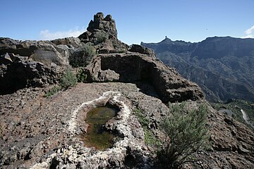 Ritual place (almogarén) on Bentayga rock
 -
-
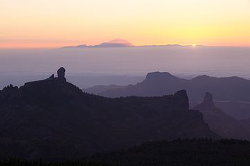 View from Las Nueves mountain
 -
 Part view of the Caldera de Tejeta. From left to right: Roque del Nublo, Timagada, Andén de Tasarte, Roque Bentayga and Los Roques. The cuevas del Rey are by the first peak on the right. Drawing by Víctor Grau-Bassas.


Conservation issues edit
June 7, 1988
Roque Bentayga, Roque de las Cuevas and Roque Narices were declared Spanish Properties of cultural interest in the same decree passed on December 18, 1990.[3]
These structures were worked in the agglomerate coming from Roque Nublo. They are constantly damaged due to the erosion that dissolves the softest zones, leaving the hardest parts to stand out - which make these vulnerable to visitors' footwear, increasing the superficial regression that blurs part of the original elements.[5]
Other archaeological parks in Grand Canary edit
The Network of Archaeological parks of Grand Canary open to the public also includes the Four Doors cave site in Telde, the caves of Valeron (cenobio de Valeron) in Santa Maria de Guia, the Arteara necropolis in Fataga, El Maipes necropolis in Agaete, the Cats' ravine (cañada de los Gatos) on Mogán beach near Puerto de Mogán, and the Painted cave (cueva Pintada) museum and archaeological park in Galdar.
Roque de las Cuevas and Roque Narices in Tejeda territory are also Properties of cultural interest ("Bien de Interés Cultural").[3]
Similar structures edit
See also edit
External links edit
Map of Heritage sites in Gran Canaria, on estodotuyo.com ( site on Heritage assets by the council of Grand Canary)
Bibliography edit
- Mederos Martin, Alfredo; Escribano Cobo, Gabriel (2002). Los aborígenes y la prehistoria de Canarias. Centro de la Cultura Popular Canaria. ISBN 84-7926-382-2.
Notes and references edit
Notes edit
- ^ Video (0.28') of the Caldera de Tejeda seen from the Degollada de la Becerra. On youtube.com.
- ^ a b c In Interpretacion del mal llamado almogaren del Bentayga, see the photo subtitled "Situación de las estructuras de la Fortaleza en la cara este del roque" ("Location of the structures of the fortress on the east side of the rock").
- ^ Mederos Martin & al., p. 27: photo of the ritual place or almogaren on Bentayga rock.
- ^ In Interpretacion del mal llamado almogaren del Bentayga, see the photo "El mal llamado almogaren del Bentayga (25 años de error)".
- ^ J.J. Jiménez Gonzalez said that a few channels that come together in the central small pan, and a few engravings, represented the feminine sex; others say that these outlines are neither channels nor a part of the schematic outlines of a feminine figure, but simply cracks in the rock due to erosion.
- ^ The possibility of the so-called "almogarén" for having been a single house later redesigned and incorporated into another dwelling was also published in Archaeology magazine nr. 256, August, 2002. See Interpretacion del mal llamado almogaren del Bentayga.
- ^ a b In Interpretacion del mal llamado almogaren del Bentayga, see the double drawing with two drawings side by side respectively called "1ª casa" and "2ª casa", before the section called "La pequeña cueva". This drawing provides a possible aspect of the two successive houses and shows how the second house reused some elements of the first house, fitting to the present remains.
See also in the same âge the drawing called "Recreación ideal de la sección de la 1ª casa" ("Virtual re-creation of the section of the 1st house"), and the one just one paragraph above it: "Plano 1ª casa" (Pln 1st house"). - ^ a b In Interpretacion del mal llamado almogaren del Bentayga, see the drawing "Descripción pavimentos diacrónicos".
- ^ In Interpretacion del mal llamado almogaren del Bentayga, see the combined photo and drawing "Seccion hogar - estufa". The photo shows the remains as they are now; the drawing shows how such a stove worked.
- ^ Víctor Grau-Bassas (1847-1918) was curator of the Museo Canario (see Comisión de antigüedades de la Real Academia de la Historia, p. 94).
- ^ In Interpretacion del mal llamado almogaren del Bentayga, see a picture of the graph in paragraph "Es caligrafía Musulmana?".
- ^ a b The lord was called a Guayre. See (in Spanish) Guía de senderos de las medianías de Gran Canaria or Explora Gran Canaria - Caldera de Tejeda.
References edit
- ^ a b Beyond the Beaches of Gran Canaria - Bentayga. October 29, 1999.
- ^ a b c (in Spanish) Explora Gran Canaria - Route 4: Caldera de Tejeda.
- ^ a b c d (in Spanish) BOC (Boletín Oficial de Canarias) N° 06, published on January 14, 1991; whereby on December 18, 1990 Roque Bentayga, Roque de las Cuevas and Roque Narices are declared Spanish Properties of cultural interest under the name "zona arqueologica de Bentaiga and los roques" (see map on page 2 of this document).
- ^ a b (in Spanish) Francisco Javier Gil Rodríguez. Andén de Tasarte, topónimo que resiste el paso del tiempo ("Andén de Tasarte, toponyme that resists the pasage of time"). September 6, 2015.
- ^ a b c d e f g h i j k l m n o p q (in Spanish) Interpretacion del mal llamado almogaren del Bentayga ("Interpretation of the ill-named ritual place of Bentayga"), on pintaderacanaria. January 10, 2009. The author is a restorer and artist for the Escuela Oficial de Madrid and archaeology specialist for the Escuela de campo de Gran Canaria; he is also part of the Comisión de Arqueología del Museo Canario.
- ^ (in Spanish) Gran Canaria - Reserva de la Biosfera ("Gran Canaria - Biosphere reserve"), established on June 29, 2005.
- ^ a b c Rock Bentayga on googlemaps.com.
- ^ a b c d Interactive map of Heritage sites on Grand Canary island. On estodotuyo.com, site on Heritage assets by the council of Grand Canary. For the information on Roque Bentayga, click on the first blue pin to the left of Tejeda (a text appears on the left of the map). The antique cave house village of cuevas del Rey is marked by the blue pin next to it on the left, and the antique cave house village of Acusa Seca is again the blue pin next to the latter on its left.
- ^ a b Topographic map of Grand Canary island on en-us.topographic-map.com.
- ^ (in Spanish) Artenara - BIC on grancanaria.es. Note: "BIC" stands for "Bien de Interés Cultural" ("Property of cultural interest").
- ^ (in Spanish) [file:///C:/Users/user/AppData/Local/Temp/boc-a-2010-061-1723.pdf Acusa Seca - Declaration as "Bien de Interés Cultural"] (Property of cultural interest), March 11, 2010. Published in B.O.C. (Boletín Oficial de Canarias) nr. 61] on March 26, 2010.
- ^ (in Spanish) Ana Santana (2015). Una violenta erupción creó una gigantesca caldera de colapso en Gran Canaria - Tejeda, un claro ejemplo a nivel planetario de una caldera de colapso ("A violent eruption creates a gigantic collapse crater in Grand Canary - Tejeda, a clear example on a planetary level of a collapse crater"). Santa Cruz de Tenerife, March 26, 2015. On efeverde.com.
- ^ (in Spanish) Roque Bentayga pondrá en valor el patrimonio histórico y etnográfico de Gran Canaria. In maspalomasnews.com, 27/10/2013.
- ^ a b c d e Cite error: The named reference
exploraCalderawas invoked but never defined (see the help page). - ^ Mederos Martin & al. 2002, p. 27.
- ^ Mederos Martin & al. 2002, p. 141.
- ^ (in Spanish) Jiménez Sánchez, J. Excavaciones Arqueológicas en Gran Canaria del Plan Nacional de 1942, 1943 y 1944 ("Archaeological digs in Grand Canary, National Plan of 1942, 1943 and 1944"). Madrid, 1946.
- ^ Ernesto Martin Rodríguez. Los lugares de culto en las cimas de las montañas. Magazine El pino - historia, tradición y espiritualidad canaria nr 25. 2002
- ^ César Esteban, Juan Antonio Belmonte and Antonio Aparicio. Arqueoastronomía Hispánica, chapter 6: Astronomía y calendario entre las culturas aborígenes Canarias ("Astronomy and calendar in the Canarian aboriginal cultures").
- ^ J. Alberto Bachiller Gil. La ciudad en la prehistoria. Los asentamientos prehispánicos en la isla de Gran Canaria como objeto de análisis ("The city in prehistory. The pre-Hispanic settlements in the island of Great Canary as object of analysis"). In magazine el Pajar nr 21, August 2006. A photo of the so-called almogarén is described as an enclave associated with the practice of rites and an astronomic observatory.
- ^ Mederos Martin & al. 2002.
- ^ Alfredo Mederos Martin, Vicente Valencia Afonso, Gabriel Escribano Cobo. Arte Rupestre de la Prehistoria de las islas Canarias (Rock Art of the Prehistory of the islands Canaries). 2003. page 83 there is a photo of the place with the legend: "Sight of the almogaren in the top of the Roque de Bentayga".
- ^ Municipality of La Aldea de San Nicolás on googlemaps.com.
[[:Category:History of the Canary Islands
[[:Category:Gran Canaria
[[:Category:Bien de Interés Cultural landmarks in the Canary Islands
[[:Category:Archaeological sites in Spain
[[:Category:Visitor attractions in the Canary Islands
[[Category:Landforms of Spain
[[Category:Mountains of the Canary Islands