Place Verte | |
|---|---|
| City square | |
 The place Verte view from the Rive gauche shopping center towards the Inno store and the Molière bookstore. | |
| Surface | 7300 sqm |
| Location | Charleroi, Belgium |
 Click on the map for a fullscreen view | |
| Coordinates (Square): 50°24′29″N 4°26′32″E / 50.407920°N 4.442290°E | |
The place Verte, the "Green Square" in french, is one of the largest and most important squares in the lower town of Charleroi (Belgium).It is surrounded on its four sides by buildings and is crossed in the north by the boulevard Joseph Tirou.
Odonymy edit
The square was successively called Place Verte (1706)[1], Place du Sud (end of the 19th century), and finally Place Albert I. This name was given by the municipality in 1934 to honor the third king of the Belgians[2][3].
In 2017, after the reconfiguration, and in order to eliminate the duplication of names in the municipality, the square was given its original name "Place Verte"[4].
History edit

The Ville-Basse, "lower city", of Charleroi was created in 1675[5] to defend the wooden bridge with a movable part thrown over the Sambre to allow access to the fortress, the Ville-Haute, "upper city", from the south. At the Ville-Basse, this bridge led to a small area surrounded by water. A final wooden drawbridge had to be crossed to reach the "Place d'Armes de la Basse-Ville" ("place-of-arms fo the lower city")[6]. From this central square, two quays and four radiating streets start[7]. The current streets of Marcinelle, Charles Dupret, Puissant d'Agimont and the rue de Marchienne follow the same route.
A fifth street was originally planned, as shown in a handwritten plan by Vauban. But the construction of the Capuchin convent meant that it was not built. This street, the counterpart of the present rue Charles Dupret, was to be located approximately at the place of the present rue du Collège, which was pierced in 1837 through the former site of the garden of the community that disappeared during the French Revolution[7].
.jpg)
After the capture of the city in 1746 by the Prince of Conti during the War of the Austrian Succession and its return to Austria by Louis XV in 1748, the fortifications were partially dismantled. The reduction disappeared and a standing stone bridge replaced the wooden one. Ferraris' map from the end of the 18th century shows that the square was at that time surrounded by buildings, including on the north side, along the Sambre.
_-1e_feuille.jpg)
For a long time, the square was only a meadow surrounded by an alley of lime trees, girdled from 1819 by blue stone pillars linked by chains[2]. The trees disappeared little by little. The last ones were cut down in August 1861 and replaced by seventeen candelabras as part of a beautification plan decided on March 2, 1862[8]. The pillars were removed in 1890 and bought back by the municipality of Mont-sur-Marchienne to decorate the town square. The pillars were removed in 1890 and bought back by the commune of Mont-sur-Marchienne to decorate the town square[2].
A mobile metal bandstand was inaugurated in 1887. It disappeared after the First World War[9].
After the Second World War, the filling in of the old arm of the Sambre, begun in the early 1930s, was completed and the boulevard Joseph Tirou which replaced it was inaugurated in 1948. The buildings that separated the square from the river were demolished and replaced by the commercial building Nouvelles Galeries in 1953. Except for the construction of new buildings, including the Albert Centre, the area generally retained its general layout for some 40 years.
In the early 1990s, a 150-space parking garage was built underground[8] , doubling the number of spaces available. This work raised the level of the square in relation to the surrounding buildings.
Reconfiguration of the 2010s edit
Following the construction of the Rive Gauche shopping center, the square is totally reconfigured to meet the needs and requirements of the new context. The proposal of the architectural firm MSA is to design a multifunctional pedestrian space from facade to facade, free of obstacles and cars. Therefore, in order to make this space unitary and legible, a mineral floor covering with a homogeneous light-dark pattern is designed. Part of the traffic is placed in the tunnel under the Boulevard Joseph Tirou, leaving only the City-Bus passage. In the basement, a multi-storey parking lot accessible via a stairwell to the south and the Rive Gauche shopping center to the west are planned[10].
The square was inaugurated on March 9, 2017 in the presence of the mayor of Charleroi Paul Magnette[11].
Buildings and monuments edit
With a few exceptions, most of the buildings that surrounded and still surround the square are banks and shops, cafés or restaurants and other places of entertainment[12][13].
In front of the Molière bookstore is a statue of Gaston Lagaffe with his Fiat 509, officially inaugurated on September 17, 2021[14]. Made in partnership with the publishing house Dupuis, it involved the same artist as the Spirou of the Charleroi-Sud station[15].
-
 Aerial view of the Ville-Basse and the square in 1919.
 -
 The square around 1900, looking southwest.
 -
 The square between 1911 and 1918, looking north-east with the kiosk.
 -
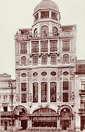 The former Guildhall (no longer standing) built in 1925 by Joseph André.


-
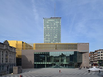 Rive gauche and the Centre Albert.
 -
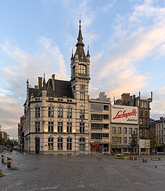
 IFAPME headquarters in the buildings of the former Bank of Charleroi built by Emile Devreux in 1920.
 -
 Former Post Office and to its right, a building built by Marcel Leborgne in 1953.
 -
 Gaston Lagaffe and his Fiat 509 in contravention on the Place Verte.


.jpg)

Events edit
In 1760, the Empress Maria Theresa authorized the organization of jeu de paume competitions in the square[2]. This is the ancestor of the pelota or ball game, for which the square was the site of numerous competitions that attracted large crowds in the last quarter of the 19th century and the first half of the 20th century[16].
For many years, the square has also been the site of a market held on Tuesdays, Thursdays and Saturdays. This was moved to the Place de la Digue in May 2014 following construction[17], but it returned to the Place Vert in July 2017[18].
Since 2017, during the Christmas market, one of the five highlights of the Big five, in addition to the chalets deployed on the Place de la Digue, the Place Verte hosts an ice rink[19].
Place of the finish of the "10 miles of Charleroi "[20].
References edit
- ^ Deprez, Anne (2011). Histoire urbaine et architecturale de la place Albert Ie (in French). p. 122. ISBN 978-2-87522-075-2.
{{cite book}}:|work=ignored (help) - ^ a b c d Everard, Jean (1959). Monographie des rues de Charleroi (in French). Charleroi: Collins. pp. 19–20.
- ^ Deprez, Anne (2011). Histoire urbaine et architecturale de la place Albert Ie (in French). p. 123. ISBN 978-2-87522-075-2.
{{cite book}}:|work=ignored (help) - ^ Albin, Didier. "Changement de nom de rues à Charleroi: le cauchemar du GPS". La Libre.be (in French). Retrieved 2022-11-24.
- ^ Hasquin, Hervé (1971). Une mutation, le Pays de Charleroi aux XVIIe et XVIIIe siècles : aux origines de la Révolution industrielle en Belgique (PDF) (in French). Brussels: Éditions de l'Institut de Sociologie de l'Université Libre de Bruxelles. pp. 303–304.
- ^ Le Plan en relief de Charleroi : levé par les ingénieurs militaires français en 1696 (2e éd ed.). Bruxelles: Crédit communal. 1986. p. 60. ISBN 2-87193-006-6. OCLC 26797720.
- ^ a b Le Plan en relief de Charleroi : levé par les ingénieurs militaires français en 1696 (2e éd ed.). Bruxelles: Crédit communal. 1986. p. 44. ISBN 2-87193-006-6. OCLC 26797720.
- ^ a b Mac Kay, Philippe (October 1996). Charleroi d'hier et d'aujourd'hui : rue par rue (in French). Charleroi: La Nouvelle Gazette. p. 6.
- ^ Everard, Jean (1959). Monographie des rues de Charleroi (in French). Charleroi: Collins. p. 25.
- ^ Charleroi métropole : guide, architecture moderne et contemporaine, 1881-2017 (in French). Iwan Strauven, Judith Le Maire, Marie-Noëlle Dailly. Bruxelles (Belgique). 2017. p. 164. ISBN 978-2-8047-0367-7. OCLC 1020583104.
{{cite book}}: CS1 maint: location missing publisher (link) CS1 maint: others (link) - ^ telesambre. "Charleroi: inauguration de la Place Verte". Télésambre (in French). Retrieved 2022-11-28.
- ^ Everard, Jean (1959). Monographie des rues de Charleroi (in French). Charleroi: Collins. pp. 21–24.
- ^ Nonclercq, Philippe (2016). Charleroy autrefois : ses rues, ses quartiers, son histoire. Liège: Noir Dessin Production. pp. 43–50. ISBN 978-2-87351-329-0.
- ^ "Oah, Gaston Lagaffe s'installe sur la place Verte: voici les premières images!". sudinfo.be (in French). Retrieved 2022-11-28.
- ^ "Gaston Lagaffe est arrivé sur la place Verte et sera inauguré officiellement ce vendredi". sudinfo.be (in French). 2021-09-15. Retrieved 2022-11-28.
- ^ Nonclercq, Philippe (2016). Charleroy autrefois : ses rues, ses quartiers, son histoire. Liège: Noir Dessin Production. pp. 40–42. ISBN 978-2-87351-329-0.
- ^ Nonclercq, Philippe (2016). Charleroy autrefois : ses rues, ses quartiers, son histoire. Liège: Noir Dessin Production. p. 51. ISBN 978-2-87351-329-0.
- ^ "Le marché de Charleroi déménage enfin sur la place Verte". sudinfo.be (in French). Retrieved 2022-11-28.
- ^ "Véritable foule pour l'inauguration du marché de Noël de Charleroi: nos plus belles photos". sudinfo.be (in French). 2017-12-01. Retrieved 2022-11-28.
- ^ "Participation record pour les 10 Miles de Charleroi - Télévision locale de Charleroi et sa région - Thuin - Chimay - Basse Sambre". www.telesambre.be. Retrieved 2022-11-28.