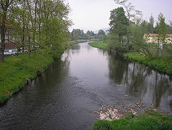
The Ulster is a 57-kilometre-long (35 mi) river in Central Germany that flows through the states of Thuringia and Hesse.
| Ulster | |
|---|---|
 | |
 | |
| Location | |
| Country | Germany |
| States | Hesse and Thuringia |
| Physical characteristics | |
| Source | |
| • location | Rhön Mountains |
| • coordinates | 50°50′32″N 9°59′7″E / 50.84222°N 9.98528°E |
| Mouth | |
• location | Werra |
• coordinates | 50°50′36″N 9°59′5″E / 50.84333°N 9.98472°E |
| Length | 57.3 km (35.6 mi) [1] |
| Basin size | 422 km2 (163 sq mi) [1] |
| Basin features | |
| Progression | Werra→ Weser→ North Sea |
The river originates in the Rhön Mountains, near the town of Ehrenberg. It then flows primarily in a northerly direction, through the towns of Hilders, Tann, Geisa, and Unterbreizbach. It flows from the left into the Werre River in Philippsthal.
See also
editReferences
edit