The Blue is a central market place in Bermondsey, southeast London.[1] The market is open Monday to Saturday from 9 am until 5 pm and has about 10 stall holders, selling food and clothes.[2][3] The area has been known locally as The Blue for more than two hundred and thirty years and is probably named after the original Blue Anchor public house that gave its name to Blue Anchor Lane.[4][5][6] The market has capacity for 24 stalls.[7]
.JPG) Market stalls in The Blue | |
| Location | Bermondsey, Southwark, Greater London |
|---|---|
| Coordinates | 51°29′32.48″N 0°03′48.96″W / 51.4923556°N 0.0636000°W |
| Address | Southwark Park Road |
| Management | Southwark London Borough Council |
| Owner | Southwark London Borough Council |
| Environment | Outdoor |
| Goods sold | General goods |
| Days normally open | Monday–Saturday |
| Number of tenants | 24 |
Immediately north of Blue Anchor Lane on an arched viaduct are the multiple railway tracks of the Brighton and South East Main Lines. The Blue Anchor Lane joins St. James's Road where the viaduct arches to the immediate north west contain the remnants of the disused Spa Road railway station which was the original terminus of London's first railway.
In 2005 a Metropolitan Police report described the area as a crime hotspot for "race crime and youth disorder".[8] In October 2014 The Blue became a Business Improvement District (BID).[9][10]
-
 The Blue Anchor pub built in 1876. The area known as The Blue was probably named after a previous tavern of the same name, probably on this site.
 -
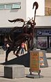 This representation of the Bermondsey Lion was created by Kevin Boys for Southwark Council. It was unveiled on 16 July 2011.
 -
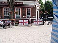 The Old Bank pub is situated on the corner of the square and Southwark Park Road. The flags represent support for England and Millwall Football Club whose ground The Den is close to The Blue.
 -
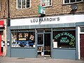 A Pie and mash shop on Southwark Park Road in The Blue. Pie, mash and eels is a traditional dish in the East End and South East London.
.JPG)
_2.JPG)
.JPG)
.JPG)
References edit
- ^ Bermondsey Community Council, on the website of Southwark Council "The central market place in Bermondsey is called The Blue. We’re not clear why it’s called The Blue, but possibly because of Bermondsey’s nautical ties or its location to Blue Anchor Road. If anyone knows better, let us at Bermondsey community council know!"
- ^ The Blue Market, www.bluemarket.co.uk, retrieved 15 March 2013
- ^ Street markets of Southwark, www.myvillage.com, archived from the original on 13 September 2008
- ^ A short account of the PARISH OF BERMONDSEY with notes on its boundaries
- ^ Haines, Kenneth Alford, A Bermondsey Boy's War. Part 2-Prelude to the Blitz, BBC, archived from the original on 30 April 2011 "An archive of World War II memories written by the public, gathered by the BBC". "known as the 'Blue,' after a pub called the 'Blue Anchor' on the corner of Blue Anchor Lane".
- ^ Walford, Edward (1878), Bermondsey: The abbey', Old and New London: Volume 6 (1878), British History Online, pp. 117–133 Describes the area around the Blue Anchor Road, that was according to the source named after the Blue Anchor pub.
- ^ "Find a market", National Market Traders Federation, retrieved 28 November 2015
- ^ 2913/Southwark Crime A4 AW: Southwark Borough Crime and Disorder Strategy (PDF), Metropolitan Police, 1 January 2005, p. 18 (PDF p. 19), archived from the original (PDF) on 22 December 2010
- ^ Southwark Labour Party (14 July 2014). "Southwark Labour welcomes Blue Bermondsey Business Improvement District". Southwark Labour Party. Retrieved 26 September 2017.
- ^ Wingfield, Ian (22 July 2014). "Forward - London Borough of Southwark" (PDF). Southwark Council. Retrieved 26 September 2017.
Further reading edit
Art
- Bermondsey Blue Market mural, positivearts.co.uk, 25 June 2011, retrieved 15 March 2013: "a large mural project funded by Southwark, Cleaner greener safer department and organised in partnership with Community Space Challenge. We transformed a dull and neglected wall to create a large mural depicting the famous ‘Blue Market’ in the 1960s featuring a traditional scene with barrow boy and original stalls".
- Craven, Stephen (23 July 2011), The Bermondsey Lion, Geograph Project Limited, retrieved 15 March 2013: "The sculpture was designed and made by local blacksmith Kevin Boys, and cost about £60,000."
Commercial
- "Blue Bermondsey", Blue Bermondsey, 10 December 2014, retrieved 26 September 2017
- BBBA staff (March 2013), The Blue Bermondsey Business Association's website, The Blue Bermondsey Business Association (BBBA), retrieved 15 March 2013
- SC staff (March 2013), The Blue, Southwark Council, retrieved 15 March 2013