Test case 1
edit
All parameters
Infobox tunnel| [[File:{{{image}}}|{{{image_size}}}|alt={{{alt}}}]] {{{caption}}} | |
| Official name | {{{official_name}}} |
|---|
| Other name(s) | {{{other_name}}} |
|---|
| Line | {{{line}}} |
|---|
| Location | {{{location}}} |
|---|
| Coordinates | {{{coordinates}}} |
|---|
| OS grid reference | {{{os_grid_ref}}} |
|---|
| Status | {{{status}}} |
|---|
| System | {{{system}}} |
|---|
| Waterway | {{{waterway}}} |
|---|
| Route | {{{route}}} |
|---|
| Start | {{{start}}} |
|---|
| End | {{{end}}} |
|---|
| No. of stations | {{{stations}}} |
|---|
|
| Work begun | {{{startwork}}} |
|---|
| Constructed | {{{construction}}} |
|---|
| Closed | {{{closed}}} |
|---|
| Rebuilt | {{{rebuilt}}} |
|---|
| Owner | {{{owner}}} |
|---|
| Operator | {{{operator}}} |
|---|
| Traffic | {{{traffic}}} |
|---|
| Character | {{{character}}} |
|---|
| Toll | {{{toll}}} |
|---|
| Vehicles per day | {{{vpd}}} |
|---|
|
| Design engineer | {{{engineer}}} |
|---|
| Length | {{{length}}} |
|---|
| Line length | {{{linelength}}} |
|---|
| Track length | {{{tracklength}}} |
|---|
| No. of tracks | {{{notrack}}} |
|---|
| No. of lanes | {{{lanes}}} |
|---|
| Track gauge | {{{gauge}}} |
|---|
| Electrified | {{{el}}} |
|---|
| Operating speed | {{{speed}}} |
|---|
| Highest elevation | {{{hielevation}}} |
|---|
| Lowest elevation | {{{lowelevation}}} |
|---|
| Tunnel clearance | {{{height}}} |
|---|
| Width | {{{width}}} |
|---|
| Water Depth | {{{depth}}} |
|---|
| Towpath | {{{towpath}}} |
|---|
| Boat-passable | {{{passable}}} |
|---|
| Grade | {{{grade}}} |
|---|
|
| {{{map}}} | | {{{extra}}} |
|
Infobox tunnel/sandbox| [[File:{{{image}}}|{{{image_size}}}|alt={{{alt}}}]] | | {{{caption}}} | |
| Official name | {{{official_name}}} |
|---|
| Other name(s) | {{{other_name}}} |
|---|
| Line | {{{line}}} |
|---|
| Location | {{{location}}} |
|---|
| Coordinates | {{{coordinates}}} |
|---|
| OS grid reference | {{{os_grid_ref}}} |
|---|
| Status | {{{status}}} |
|---|
| System | {{{system}}} |
|---|
| Waterway | {{{waterway}}} |
|---|
| Route | {{{route}}} |
|---|
| Start | {{{start}}} |
|---|
| End | {{{end}}} |
|---|
| No. of stations | {{{stations}}} |
|---|
|
| Work begun | {{{startwork}}} |
|---|
| Opened | {{{open}}} |
|---|
| Closed | {{{closed}}} |
|---|
| Rebuilt | {{{rebuilt}}} |
|---|
| Reopened | {{{reopen}}} |
|---|
| Owner | {{{owner}}} |
|---|
| Operator | {{{operator}}} |
|---|
| Traffic | {{{traffic}}} |
|---|
| Character | {{{character}}} |
|---|
| Toll | {{{toll}}} |
|---|
| Vehicles per day | {{{vpd}}} |
|---|
|
| Design engineer | {{{engineer}}} |
|---|
| Construction | {{{construction}}} |
|---|
| Length | {{{length}}} |
|---|
| Line length | {{{linelength}}} |
|---|
| Track length | {{{tracklength}}} |
|---|
| No. of tracks | {{{notrack}}} |
|---|
| Number of lanes | {{{lanes}}} |
|---|
| Track gauge | {{{gauge}}} |
|---|
| Electrified | {{{el}}} |
|---|
| Operating speed | {{{speed}}} |
|---|
| Highest elevation | {{{hielevation}}} |
|---|
| Lowest elevation | {{{lowelevation}}} |
|---|
| Tunnel clearance | {{{height}}} |
|---|
| Width | {{{width}}} |
|---|
| Water Depth | {{{depth}}} |
|---|
| Towpath | {{{towpath}}} |
|---|
| Boat-passable | {{{passable}}} |
|---|
| Grade | {{{grade}}} |
|---|
|
| {{{map}}} | | {{{extra}}} |
|
Test case 2
edit
Channel Tunnel (see Category:Railway tunnels)
Test case 3
edit
Holland Tunnel (see Category:Road tunnels)
Infobox tunnel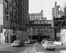 Manhattan entrance to tunnel, 1985 | |
| Official name | Clifford Milburn Holland Tunnel |
|---|
| Location | Connecting Jersey City, New Jersey to Lower Manhattan in New York City, USA |
|---|
| Route |  I-78 and I-78 and  Route 139 (which ends at NJ/NY State Line) Route 139 (which ends at NJ/NY State Line) |
|---|
| Crosses | Hudson River |
|---|
|
| Operator | Port Authority of New York and New Jersey |
|---|
| Traffic | 93,356 (2010) |
|---|
| Toll | (eastbound only) As of 2 December 2012[update]; Cars $13 for cash, $10.25 for Peak (E-ZPass), $8.25 for off-peak (E-ZPass) |
|---|
|
| Length | 8,558 feet (2,608.5 m) (westbound)
8,371 feet (2,551.5 m) (eastbound) |
|---|
| No. of lanes | 4 |
|---|
| Tunnel clearance | 12.5 feet (3.8 m) |
|---|
|
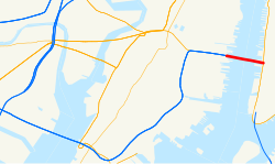 Route map of the Lincoln Tunnel Route map of the Lincoln Tunnel | | |
Holland Tunnel | | | |
| 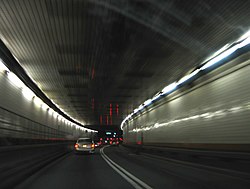 Interior view of Holland Tunnel, 2006 | | Location | Jersey City, NJ and New York, NY |
|---|
| Built | 1920 |
|---|
| Architect | Clifford Holland |
|---|
| NRHP reference No. | 93001619 |
|---|
|
| Added to NRHP | November 4, 1993 |
|---|
| Designated NHL | November 4, 1993 |
|---|
|
|
|
Infobox tunnel/sandbox | | Manhattan entrance to tunnel, 1985 | |
| Official name | Clifford Milburn Holland Tunnel |
|---|
| Location | Connecting Jersey City, New Jersey to Lower Manhattan in New York City, USA |
|---|
| Route | I-78 and Route 139 (which ends at NJ/NY State Line) |
|---|
|
| Opened | November 13, 1927 (1927-11-13) |
|---|
| Operator | Port Authority of New York and New Jersey |
|---|
| Traffic | 93,356 (2010) |
|---|
| Toll | (eastbound only) As of 2 December 2012[update]; Cars $13 for cash, $10.25 for Peak (E-ZPass), $8.25 for off-peak (E-ZPass) |
|---|
|
| Length | 8,558 feet (2,608.5 m) (westbound)
8,371 feet (2,551.5 m) (eastbound) |
|---|
| Number of lanes | 4 |
|---|
| Tunnel clearance | 12.5 feet (3.8 m) |
|---|
|
| Route map of the Lincoln Tunnel | | |
Holland Tunnel | | | |
| Interior view of Holland Tunnel, 2006 | | Location | Jersey City, NJ and New York, NY |
|---|
| Built | 1920 |
|---|
| Architect | Clifford Holland |
|---|
| NRHP reference No. | 93001619 |
|---|
|
| Added to NRHP | November 4, 1993 |
|---|
| Designated NHL | November 4, 1993 |
|---|
|
|
|
Test case 4
edit
Alva B. Adams Tunnel (see Category:Water tunnels)


