Talk:List of storms in the 2006 Pacific hurricane season/Daniel
05E.Daniel edit
AoI:07W2B-E: Behind Carlotta edit
The parade is on; a new burst of convection over Central America. Could this develop? CrazyC83 03:07, 13 July 2006 (UTC)
- Yes, it's looking quite good, but shear remains high. We'll see. I give it a 50% chance of becoming Daniel. -- WmE 17:52, 13 July 2006 (UTC)
- Looks within 24-48 hours, they may turn into at least a tropical storm(s). Also I see favoritable conditions since Bud and Carlotta were born near the same place. But how many disturbances are there, like the exact number. Alastor Moody (talk) 20:29, 13 July 2006 (UTC)
- It is not even mentioned in the TWO, so I am not nearly as convinced at this point. It is likely several days from development. CrazyC83 01:20, 14 July 2006 (UTC)
- Looks within 24-48 hours, they may turn into at least a tropical storm(s). Also I see favoritable conditions since Bud and Carlotta were born near the same place. But how many disturbances are there, like the exact number. Alastor Moody (talk) 20:29, 13 July 2006 (UTC)
Well currently I think there is somehat of an answer of two new disturbances forming, but one on the right seems somewhat organized with bands of rain clouds clustering about off the Panama coastline, while the left one (behind Carlotta) is sort-of scattered everywhere which is less organized as the satellite pictures reveal. But maybe by this Monday or Tuesday, it may develope into tropical systems and possibly die at the same fate Hurricane Bud is experiencing now. Alastor Moody (talk) 07:31, 13 July 2006 (UTC)
- NEW UPDATE: Two tropical disturbances are forming well off the western coast of Central America and have developed over past 24 hours. I expect them to develope more by this Tuesday. Alastor Moody (talk) 18:33, 13 July 2006 (UTC)
- Shear isn't that high in that area, so it has a chance of development. However they won't explode like Bud or Carlotta. A TD or TS is possible. -- WmE 19:39, 14 July 2006 (UTC)
- That's why, although I'm not sure as of yet of how they will decline, like I said above, by early to mid next week, the disturbances both may at least turn into tropical storms or possibly even a Category 1 hurricane like Carlotta, if conditions allow like little wind shear and warm sea temperatures.Alastor Moody (talk) 22:00, 14 July 2006 (UTC)
- Hey, wake up everyone! A tropical disturbance of Central America has no developed further and has a spiral structure around it! Although it is not yet an invest yet. Alastor Moody (talk) 07:10, 14 July 2006 (UTC)
- Well, I guess it's 91E. now. -- WmE 10:30, 16 July 2006 (UTC)
- Hey, wake up everyone! A tropical disturbance of Central America has no developed further and has a spiral structure around it! Although it is not yet an invest yet. Alastor Moody (talk) 07:10, 14 July 2006 (UTC)
- That's why, although I'm not sure as of yet of how they will decline, like I said above, by early to mid next week, the disturbances both may at least turn into tropical storms or possibly even a Category 1 hurricane like Carlotta, if conditions allow like little wind shear and warm sea temperatures.Alastor Moody (talk) 22:00, 14 July 2006 (UTC)
- Shear isn't that high in that area, so it has a chance of development. However they won't explode like Bud or Carlotta. A TD or TS is possible. -- WmE 19:39, 14 July 2006 (UTC)
Let me make this clear - even if this gets me a warning. We don't CARE what you think will happen, we don't care what you THINK is happening, you're not a hurricane expert, WAIT FOR THE NHC. If the NHC/TPC/NWS doesn't say "two tropical disturbances are forming well off the Western coast of Central America and have developed", then it HASN'T happened. What you think may not be right. I've been watching you repeat yourself as if you were a hurricane expert, for Bud, Carlotta, and now this. We don't care. Chacor 14:30, 16 July 2006 (UTC)
- We? Don't you mean you? íslenska hurikein #12 (samtal) 15:16, 16 July 2006 (UTC)
- Well, you are right. I'm no hurricane expert (I live in a landlocked country), and it wasn't my intention to sound like a hurricane expert. I'm only interested in tropical cyclones and probably not as experienced as you all. However, in my defense: I've NEVER EVER said that two tropical cyclones HAVE FORMED or ARE FORMING, NEVER. And that Invest story: I NEVER said that it MUST/SHOULD/OUGHT TO be an invest now. I wasn't sure whether this invest is this AoI or not. Well, I'm sorry for offending you, it wasn't my intention. -- WmE 16:54, 16 July 2006 (UTC)
91E.INVEST edit
Just appeared. -- RattleMan 07:41, 16 July 2006 (UTC)
- It's about time. bob rulz 14:05, 16 July 2006 (UTC)
- TCFA. íslenska hurikein #12 (samtal) 15:19, 16 July 2006 (UTC)
- Development likely now. I'd say this becomes Daniel. CrazyC83 16:17, 16 July 2006 (UTC)
- TCFA. íslenska hurikein #12 (samtal) 15:19, 16 July 2006 (UTC)
AN AREA OF CLOUDINESS AND SHOWERS...ASSOCIATED WITH A TROPICAL DISTURBANCE...IS LOCATED ABOUT 730 MILES SOUTH OF THE SOUTHERN TIP OF BAJA CALIFORNIA. THIS SYSTEM CONTINUES TO GET BETTER ORGANIZED...AND A TROPICAL DEPRESSION COULD FORM TONIGHT OR MONDAY AS IT MOVES WESTWARD AROUND 10 TO 15 MPH.
Will we see TD-5E tonight? I guess we'll have Daniel tomorrow. -- WmE 22:46, 16 July 2006 (UTC)
Tropical Depression 5-E edit
This is now Tropical Depression 5-E according to the NRL. [1] --Ajm81 00:55, 17 July 2006 (UTC)
- No surprise. It looked like a depression already. CrazyC83 01:00, 17 July 2006 (UTC)
- An advisory has been issued. íslenska hurikein #12 (samtal) 02:39, 17 July 2006 (UTC)
- Hurricane in 48 hours, and "there is a chance for rapid intensification" after then. I've added everything to the article. --Coredesat talk. o.o;; 03:02, 17 July 2006 (UTC)
- The water that TD5-E/Daniel is going over is warmer than Bud. I smell a MONSTER brewing here... CrazyC83 03:12, 17 July 2006 (UTC)
- Let's see what the future Daniel is going to do; I bet this is going to be a big one, possibly a titantic summer storm; also another system 92E.INVEST is bound to be future Emilia within 36-60 hours, enough time to develope. Alastor Moody (talk) 04:55, 17 July 2006 (UTC)
- The water that TD5-E/Daniel is going over is warmer than Bud. I smell a MONSTER brewing here... CrazyC83 03:12, 17 July 2006 (UTC)
- Hurricane in 48 hours, and "there is a chance for rapid intensification" after then. I've added everything to the article. --Coredesat talk. o.o;; 03:02, 17 July 2006 (UTC)
- An advisory has been issued. íslenska hurikein #12 (samtal) 02:39, 17 July 2006 (UTC)
Tropical Storm Daniel edit
NRL has it as 05E.DANIEL, but NHC has not yet upgraded it. Chacor 13:33, 17 July 2006 (UTC)
- They likely will at 11:00. íslenska hurikein #12 (samtal) 13:35, 17 July 2006 (UTC)
- Yeah, we have Daniel now. 35kts, 1004mbar. -- WmE 14:34, 17 July 2006 (UTC)
- I think they're being too conservative with their forecasts, like they were with Bud. This thing could easily wind up being as strong as Bud, if not stronger. There's nothing to inhibit intensification. bob rulz 16:18, 17 July 2006 (UTC)
- Things are getting better for Tropical Storm Daniel. Alastor Moody (talk) 21:06, 17 July 2006 (UTC)
- I think they're being too conservative with their forecasts, like they were with Bud. This thing could easily wind up being as strong as Bud, if not stronger. There's nothing to inhibit intensification. bob rulz 16:18, 17 July 2006 (UTC)
- Yeah, we have Daniel now. 35kts, 1004mbar. -- WmE 14:34, 17 July 2006 (UTC)
- Expect hurricane status very soon. Pobbie Rarr 01:21, 18 July 2006 (UTC)
A central eye is bound to be forming as shown in the US Navy NRL satellite picture where it shows deep convection and seems to be undergoing rapid intensification. The NHC currently expect a hurricane later today as shown in this link. → Hurricane Daniel wind speed probabilities Alastor "Mad-Eye" Moody 17:43, 18 July 2006 (UTC)
Hurricane Daniel edit
NRL has it at 65 knots, 987 mb. -- RattleMan 19:07, 18 July 2006 (UTC)
- So an NHS update at 4pm should show it as a Hurricane. Reub2000 19:24, 18 July 2006 (UTC)
- An eye seems to be forming at Daniel. I also got a satellite picture from the NRL as shown here. → [2] Alastor Moody (talk) 23:15, 18 July 2006 (UTC)
- Looks nice. Expect major hurricane status (and possibly rapid strengthening) within the next few days. Pobbie Rarr 01:04, 19 July 2006 (UTC)
- I think it is already on its way to rapid intensifying. Alastor Moody (talk) 01:15, 18 July 2006 (UTC)
- Cat. 2 now. íslenska hurikein #12 (samtal) 15:07, 19 July 2006 (UTC)
- I think it is already on its way to rapid intensifying. Alastor Moody (talk) 01:15, 18 July 2006 (UTC)
- Looks nice. Expect major hurricane status (and possibly rapid strengthening) within the next few days. Pobbie Rarr 01:04, 19 July 2006 (UTC)
Daniel is looking really, really good now. Looks already like a major hurricane.-- WmE 00:11, 20 July 2006 (UTC)
- It's eye is forming! Alastor Moody (talk) 01:22, 20 July 2006 (UTC)
- It's always been there. The NHC discussion from sometime yesterday noted a pinhole eye (like Katrina or Wilma). Chacor 01:24, 20 July 2006 (UTC)
- Okay, so it was there, but I was actually absent for the meantime. Alastor Moody (talk) 01:29, 20 July 2006 (UTC)
- From the latest Forecast/Advisory, "EYE DIAMETER 5 NM". NRL 95kt. Chacor 01:31, 20 July 2006 (UTC)
- Okay, so it was there, but I was actually absent for the meantime. Alastor Moody (talk) 01:29, 20 July 2006 (UTC)
- It's always been there. The NHC discussion from sometime yesterday noted a pinhole eye (like Katrina or Wilma). Chacor 01:24, 20 July 2006 (UTC)
- That's very small. The new concentric eyewall is much bigger however. Pobbie Rarr 03:13, 20 July 2006 (UTC)
- But not as small as Hurricane Wilma's eye from 2005. Wilma's eye was only; 2 NM long. Alastor Moody (talk) 04:30, 20 July 2006 (UTC)
- That's very small. The new concentric eyewall is much bigger however. Pobbie Rarr 03:13, 20 July 2006 (UTC)
Hurricane Daniel is now a strong Category 2 hurricane, so I expect it to be a Category 3 hurricane by the next advisory or the second next one. Alastor Moody (talk) 04:40, 20 July 2006 (UTC)
Major Hurricane Daniel edit
NRL has it at 100 knots, 960 mb. Forecast for peak of 110 knots (just below Cat 4 status). -- RattleMan 07:17, 20 July 2006 (UTC)
- Yeah, but if he became an annular hurricane, he'd be stronger than that forecast. -- WmE 08:37, 20 July 2006 (UTC)
INFRARED SATELLITE IMAGERY REVEALS A RATHER SYMMETRIC ANNULAR-
TYPE HURRICANE WITH A WELL DEFINED EYE ABOUT 25-30 NM IN
DIAMETER.
- Well, that was luck. Now, I expect a Cat4 hurricane at the next advisory, likely reaching its peak. -- WmE 15:07, 20 July 2006 (UTC)
- Bud is now an annular hurricane; so I expect more strengthening and a peak of a Category 4 intensity. Alastor Moody (talk) 20:00, 20 July 2006 (UTC)
- Bud?? You mean Daniel, don't you? NRL has it as 115kt cat4 hurricane now. pressure is 948mbar. -- WmE 19:12, 20 July 2006 (UTC)
- Bud is now an annular hurricane; so I expect more strengthening and a peak of a Category 4 intensity. Alastor Moody (talk) 20:00, 20 July 2006 (UTC)
- Well, that was luck. Now, I expect a Cat4 hurricane at the next advisory, likely reaching its peak. -- WmE 15:07, 20 July 2006 (UTC)
Wow, I thought Daniel looked annular. It looks really nice on satellite imagery. Does this mean it will probably maintain Cat. 4 intensity until it reaches cooler waters? Pobbie Rarr 22:18, 20 July 2006 (UTC)
- Probably. One model keeps Daniel at this strength for FOUR DAYS all the way into the CPac... CrazyC83 23:40, 20 July 2006 (UTC)
- Latest NHC advisory 120kt/942mb... stronger than last season's strongest. Max intensity forecast is 125kt in 12 h. Chacor 03:12, 21 July 2006 (UTC)
- I wouldn't be shocked to see a Category 5 come out of this, but that is still not easy to do in the EPac when there is no El Nino... CrazyC83 04:27, 21 July 2006 (UTC)
- Well it doesn't mean when there is an El Nino, a Category 5 hurricane poppes out. Although it is a rare occurance, Daniel still may get a chance to Cat. 5 status; but on the other hand, it may not achieve that category but still peak as a strong Category 4 storm. But sooner or later, this storm will then explode. Alastor Moody (talk) 05:34, 21 July 2006 (UTC)
The 2 a.m. PDT (0900 UTC) advisory weakened Daniel to 115kt due to an eyewall replacement cycle. However, the JTWC's 1000 UTC (3 a.m. PDT) noted max. winds of 120 kt. Chacor 11:10, 21 July 2006 (UTC)
Whoa, Daniel is a perfect looking annular hurricane. Beautiful! -- WmE 15:53, 21 July 2006 (UTC)
Good grief!!! Daniel looks definitely like a annular hurricane. It's perfect eye is so extraordinary. It's almost giving me the heebie-jeebies! Alastor Moody (talk) 20:10, 21 July 2006 (UTC)
- Daniel strengthened to 125kt, only 11kt more and he's a cat5. -- WmE 20:52, 21 July 2006 (UTC)
- I don't think it's going to reach it. No more than another 5-10mph of strengthening. It will get close...this could be the strongest storm of the season (unless that El Nino kicks in soon). bob rulz 21:59, 21 July 2006 (UTC)
Hey guys, NRL has Daniel at 130 knots...could he break into Category 5?! -- RattleMan 01:29, 22 July 2006 (UTC)
I'm not saying anything other than it's posssible. :P
I love annular hurricanes; they look (dare I say it) beautiful. Daniel's not quite as perfect as Isabel though. I want to see mesovortices! Pobbie Rarr 01:34, 22 July 2006 (UTC)
- Beautiful. :) [3] 203.12.220.2 02:33, 22 July 2006 (UTC)
- I agree, though Cyclone Monica was definitely the most beautiful storm recently. —Cuiviénen 03:46, 22 July 2006 (UTC)
Now officially 130 knots from the NHC, who refuse to strengthen Daniel further. Chacor 03:02, 22 July 2006 (UTC)
- We shall see. Daniel, as they say, is a fighter. —Cuiviénen 03:46, 22 July 2006 (UTC)
- Is it intensfying? I dare say this is going to peak with Category 5 winds. It is an annular hurricane by the way... Irfanfaiz 04:51, 22 July 2006 (UTC)
- I honestly believe that Daniel is a Category 5 right now. If only they would send a Recon into it... CrazyC83 04:58, 22 July 2006 (UTC)
- I hope this dosen't become a Hurricane Linda class hurricane. Irfanfaiz 05:02, 22 July 2006 (UTC)
- There is some mesovortices in the eye though ;). Irfanfaiz 05:06, 22 July 2006 (UTC)
- Gaah... 1997 was an El Niño year... this year there appears to be an El Niño forming... after Linda, there was Nora (see below) :( Titoxd(?!?) 05:08, 22 July 2006 (UTC)
- If Daniel was a southern hemisphere cyclone, it would already be a Cat. 5 hurricane. But in the satellite images from the NRL, it shows Daniel looks like a very strong Category 5 hurricane similar to Cyclone Monica of 2006 Southern Hemisphere cyclones; well maybe it is already one although the NHC dosen't recongize it. Alastor Moody (talk) 06:18, 21 July 2006 (UTC)
- Oh god. It looks like a Category 5 than it must be a Category 5. They don't send recons yet though. Irfanfaiz 06:33, 22 July 2006 (UTC)
- If Daniel was a southern hemisphere cyclone, it would already be a Cat. 5 hurricane. But in the satellite images from the NRL, it shows Daniel looks like a very strong Category 5 hurricane similar to Cyclone Monica of 2006 Southern Hemisphere cyclones; well maybe it is already one although the NHC dosen't recongize it. Alastor Moody (talk) 06:18, 21 July 2006 (UTC)
- I hope this dosen't become a Hurricane Linda class hurricane. Irfanfaiz 05:02, 22 July 2006 (UTC)
- I honestly believe that Daniel is a Category 5 right now. If only they would send a Recon into it... CrazyC83 04:58, 22 July 2006 (UTC)
- Is it intensfying? I dare say this is going to peak with Category 5 winds. It is an annular hurricane by the way... Irfanfaiz 04:51, 22 July 2006 (UTC)
Retained at 130 kt at the 2 a.m. advisory. Chacor 08:52, 22 July 2006 (UTC)
Retained... AGAIN... at 130 kt for the 5 a.m. advisory. Chacor 14:39, 22 July 2006 (UTC)
For those who say that he looks amazing...it looks even better when only poor fish colonies have to worry about him... CrazyC83 19:35, 22 July 2006 (UTC)
Down to 145mph/925mb. Looks like he has peaked. But you never know: we thought that when he first dropped to Cat. 3 from Cat. 4. Could Daniel hit Hawaii as a tropical storm? Pobbie Rarr 22:22, 22 July 2006 (UTC)
- The image i uploaded was at it's peak intensity. 933 mbar and 150 mph. Ok never mind.. Irfanfaiz 23:22, 22 July 2006 (UTC)
- Will Daniel cross the international date line and become a typhoon? Irfanfaiz 23:34, 22 July 2006 (UTC)
- Waters are too cold for him to make it that far. I do think he will make tropical storm landfall on Hawaii though, which would warrant an article. Chacor 00:15, 23 July 2006 (UTC)
- Daniel's pinwheek eye is now collapsing. Alastor Moody (talk) 02:30, 23 July 2006 (UTC)
- Waters are too cold for him to make it that far. I do think he will make tropical storm landfall on Hawaii though, which would warrant an article. Chacor 00:15, 23 July 2006 (UTC)
- Will Daniel cross the international date line and become a typhoon? Irfanfaiz 23:34, 22 July 2006 (UTC)
Retained at 125 kt for this advisory, which is impressive. Chacor 02:59, 23 July 2006 (UTC)
- Correct on the article re: Hawaii approach. If Daniel goes within reach of Hawaii (enough to affect it as at least a tropical storm or seriously threaten it), I think a separate article would be warranted, since that is fairly rare. CrazyC83 03:15, 23 July 2006 (UTC)
- It's eye looks a bit disorganized. Still retaining 145 mph. Annular hurricanes.... Irfanfaiz 03:24, 23 July 2006 (UTC)
- Daniel is certainly a warrior, even at poor conditions. If we had Bud now in Daniel's shoes (for example), it would already be gone. Alastor Moody (talk) 07:16, 23 July 2006 (UTC)
- It's eye looks a bit disorganized. Still retaining 145 mph. Annular hurricanes.... Irfanfaiz 03:24, 23 July 2006 (UTC)
NRL has it at 110kt/952mb - Cat. 3. Looks like there's no way back for Donut Daniel. Pobbie Rarr 19:34, 23 July 2006 (UTC)
Regarding a possible Hawaiian landfall, compare this to the last Hurricane Daniel in 2000. It followed a similar path, was also a major hurricane and very nearly hit Hawaii. Pobbie Rarr 19:45, 23 July 2006 (UTC)
- Anyhow, if Daniel weakns to a small tropical storm in the central pacific, will it's remants cross the dateline and regenerate in the typhoon basin? Alastor Moody (talk) 22:10, 23 July 2006 (UTC)
- I guess that it's possible... íslenska hurikein #12 (samtal) 22:55, 23 July 2006 (UTC)
- Even a cross into the Central Pacific is a rare feat (and Daniel is very close to achieving that right now). Pobbie Rarr 23:17, 23 July 2006 (UTC)
Latest 8 p.m. forecast track scores a direct TS landfall on Hawaii, will be interesting to watch. Chacor 03:04, 24 July 2006 (UTC)
- Indeed. Could Daniel do what Kenneth was barely unable to do last year? bob rulz 03:48, 24 July 2006 (UTC)
- (just looked at satellite picture) Wow, this hurricane doesn't look nearly as good as it did when it was a perfect, beautiful annular hurricane. bob rulz 03:52, 24 July 2006 (UTC)
Welcome back, Major Hurricane Daniel! 105kt from NRL at 0430Z, it was 95kt at the 0300Z advisory. Chacor 05:04, 24 July 2006 (UTC)
- Now I wonder if it'll retain major hurricane strength into the CPac. Chacor 05:05, 24 July 2006 (UTC)
I expect a possible Typhoon "Daniel", if he is able to stay strong in the CPac:-) Alastor Moody (talk) 05:36, 24 July 2006 (UTC)
- Waters are probably too cold for a hurricane-typhoon crossover. Perhaps a TS-TS crossover, before new strengthening, if waters can sustain it. Chacor 06:11, 24 July 2006 (UTC)
- Actually, the waters warm back up again just before 160W, and don't get lower than 24-25C on Daniel's forecast track. It could conceivably maintain itself until then. Shear is high over there, but is forecast to decrease. However, if Daniel makes landfall on Hawaii, it could be torn up by the mountains (though it could possibly regenerate in the warmer waters to the west). --Coredesat talk. o.o;; 06:18, 24 July 2006 (UTC)
- Given that it'd already be a weak TS, I really doubt it could regain hurricane strength. Chacor 06:28, 24 July 2006 (UTC)
- Actually, the waters warm back up again just before 160W, and don't get lower than 24-25C on Daniel's forecast track. It could conceivably maintain itself until then. Shear is high over there, but is forecast to decrease. However, if Daniel makes landfall on Hawaii, it could be torn up by the mountains (though it could possibly regenerate in the warmer waters to the west). --Coredesat talk. o.o;; 06:18, 24 July 2006 (UTC)
CPHC image of the AoR os RSMC Honolulu... Daniel's already half-inside the AoR. Chacor 06:17, 24 July 2006 (UTC)
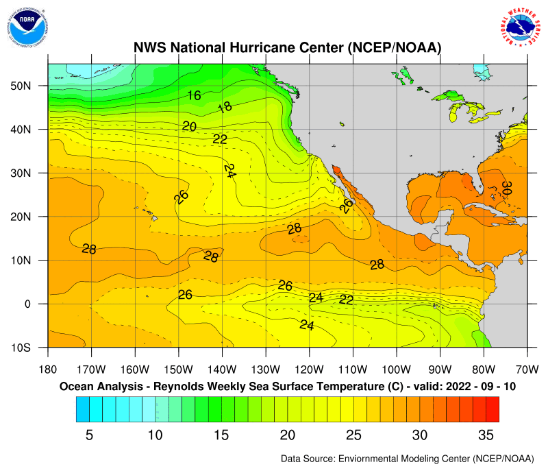
- From that water temperature image, Daniel would reintensified to a Donut Category 3 hurricane with it's eyewall affecting the Big Island or maybe a landfall. I think it will done as much damage as Hurricane Iniki? Irfanfaiz 10:00, 24 July 2006 (UTC)
The GFDL forecast for Daniel (as of 06Z 0724, or 11 pm PDT July 23) shows HI being affected only minimally with TD force winds, but there is a chance it'll be a Cat 1 hurricane as it passes through the state. Chacor 13:28, 24 July 2006 (UTC)
- Yeah, but the GFDL tries to weaken Daniel since 3 days or so. It wasn't very accurate. -- WmE 14:10, 24 July 2006 (UTC)
Looks like it's being sheared to death. 24.83.98.3 18:10, 25 July 2006 (UTC)
- Yeah, the invests on the Navy page look better organised right now. Pobbie Rarr 20:04, 25 July 2006 (UTC)
- On the contrary, Daniel is very organized but has little thunderstorm activity. The invests have thunderstorm activity, but aren't quite organized. —BazookaJoe 20:30, 25 July 2006 (UTC)
- "Look" was the key word. Pobbie Rarr 21:38, 25 July 2006 (UTC)
Daniel is now completely devoid of convection. It's probably not going to make it any further, since the low level steering currents are fairly weak. It will probably be declared a remnant low tonight or early tomorrow morning. The CPHC isn't calling for any reintensification. --Coredesat talk. o.o;; 21:50, 25 July 2006 (UTC)
- Daniel is now nothing more than bare bones and a minimal tropical storm. Alastor Moody (talk) 22:12, 25 July 2006 (UTC)
- Should be dead by now. Nothing but a swirl of low clouds, reminds me of Bud and Carlotta.--24.83.98.3 23:00, 25 July 2006 (UTC)
- The last adviory was issued. I'm sure in the TCR, it will show where the remnant low traveled, but for now, it's gone. íslenska hurikein #12 (samtal) 21:35, 26 July 2006 (UTC)
- Should be dead by now. Nothing but a swirl of low clouds, reminds me of Bud and Carlotta.--24.83.98.3 23:00, 25 July 2006 (UTC)
Remnant Low Ex-Tropical Depression Daniel edit
Daniel might not be dead yet. Convection is making a comeback, and the NHC's model package is reintensifying it into a TS within 72 hours. --Coredesat talk. o.o;; 20:32, 27 July 2006 (UTC)
- The Navy site still has it up. Pobbie Rarr 22:48, 27 July 2006 (UTC)
- Looks like a fighter.--24.83.98.3 22:53, 27 July 2006 (UTC)
10 PM HST CPac TWO:
Isolated thunderstorms continued to develop to the northwest of the weak low-level circulation representing the remnants of former tropical depression Daniel. The low center was located about 350 miles east southeast of Hilo, Hawaii. Further development of this system is not expected. Otherwise, no tropical cyclones are expected through Saturday.
It is indeed continuing to develop, although apparently it won't any further. Still 30kt from NRL, but on visible imagery it looks like an invest... a(n albeit small) cluster of clouds. Chacor 08:49, 28 July 2006 (UTC)
If anyone cares, the Big Island of Hawaii and Maui are currently under a flash flood watch due to the threat of rain from Daniel's remnants. [4] Of course, it rains so much in Hawaii that parts of the state get put under flash flood watches practically every single month so I'm not sure how noteworthy this is. 青い(Aoi) 09:27, 28 July 2006 (UTC)
- Doesn't look like much now. Chacor 10:45, 28 July 2006 (UTC)
- Just wait and see... if it causes damage or deaths. Relive Daniel's article? Irfanfaiz 10:47, 28 July 2006 (UTC)
- I copied the article to my sandbox and revised it. Here is the link to my sandbox version User:Holderca1/Hurricane Daniel (2006). --Holderca1 14:35, 28 July 2006 (UTC)
- The big island's about to be hit by (just) a nasty thunderstorm with cloud tops to -60°C. Perhaps it's getting enhanced by the updraft of air going over the volcano? The top of it is getting sheared to the north, and passing over the mountain might destroy this last bit of convection. —AySz88\^-^ 17:00, 28 July 2006 (UTC)
- I copied the article to my sandbox and revised it. Here is the link to my sandbox version User:Holderca1/Hurricane Daniel (2006). --Holderca1 14:35, 28 July 2006 (UTC)
- Just wait and see... if it causes damage or deaths. Relive Daniel's article? Irfanfaiz 10:47, 28 July 2006 (UTC)
I think daniel made landfall in Hawaii now. íslenska hurikein #12 (samtal) 17:00, 28 July 2006 (UTC)
- And I think the waters warm up right after Daniel passes through Hawaii. íslenska hurikein #12 (samtal) 17:01, 28 July 2006 (UTC)
Maybe Ex-Daniel could have been torn up by the mountains in Hawaii, but if the clouds remain well-defined and manage to cross the dateline, it could become a new tropical cyclone in the western Pacific; although I think it will be mostly unlikely. Alastor Moody (talk) 07:59, 29 July 2006 (UTC)
- Doubtful. Daniel has already for the most part passed through the Hawaiian islands and as AySz88 noted, what was left of the storm was torn apart by the tall mountains on Hawaii Island, and the weather report tonight said that most of the thunderstorms and clouds associated with Daniel have dissipated. As for the impact of the storm on Hawaii, there was very little--no flooding, no landslides, and only 15 seconds of coverage on the channel 2 news. About an inch of rain fell on Hilo but that's about it. 青い(Aoi) 08:42, 29 July 2006 (UTC)
Gone from the NRL. Alastor Moody (talk) 21:35, 29 July 2006 (UTC)