Sajek Valley (Bengali: সাজেক উপত্যকা) is a popular tourist spot in Bangladesh, situated among the hills of the Kasalong range of mountains in Sajek union parishad, Baghaichhari Upazila in Rangamati District. The valley is located 450 metres (1,480 ft) above sea level. It is known as the Queen of Hills and Roof of Rangamati.[1]
Sajek Tripuri Valley
সাজেক ত্রিপুরী উপত্যকা | |
|---|---|
| Sajek Union Parishad | |
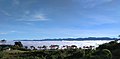
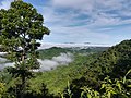
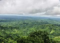
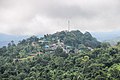
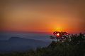
    From top: Sajek Valley View Sunrise from Konglak Hill Konglak Hill View from Helipad | |
| Nickname: রাঙামাটির ছাদ (Roof of Rangamati)[1] | |
| Coordinates: 23°38.1′N 92°29.4′E / 23.6350°N 92.4900°E | |
| Country | Bangladesh |
| District | Rangamati District |
| Upazilla | Baghaichhari |
| Settlement | 1885 CE[2] |
Name and significance edit
The designation of Sajek Valley is derived from the Sajek River, which originates from the Karnaphuli river. Serving as a natural boundary, the Sajek River delineates the border between Bangladesh and India.[3]
Geography edit
Sajek is a union parishad located in the north of Chittagong Hill Tracts, under Baghaichari upazila in Rangamati Hill District. It is situated about 70 kilometres (43 mi) to 80 kilometres (50 mi) from Khagrachhari.[2][4] The valley is located close to the Indian border state of Mizoram.[3]
Sajek Valley is known for its natural environment and is surrounded by mountains, dense forest, and grassland hill tracks. Many small rivers flow through the mountains, among which the Kachalong and the Machalong are notable. On the way to Sajek valley, one has to cross the Mayni range and the Mayni river. The road to Sajek features steep inclines and descents.[5]
People and culture edit
The inhabitants of Sajek valley comprise various ethnic minority groups, including the Chakma, Marma, Tripuri, Pankho, Lushai, and other indigenous communities. In this community, there is a notable involvement of women in economic pursuits, particularly in activities such as fruit and vegetable picking. While proficiency in Bengali may not be widespread among them, the younger generation often possesses some degree of proficiency in English.[5]
Transportation edit
The valley is more conveniently accessed via Dighinala in the Khagrachari district. Travelers can reach Khagrachari from Dhaka by bus, with options for both AC and Non-AC buses available. Covering a distance of approximately 70 kilometres (43 mi) from Khagrachari to Sajek, visitors can hire four-wheelers called chander gari (Bengali: চান্দের গাড়ি) for group travel, or opt for an autorickshaw ride if traveling in smaller groups. However, traveling by autorickshaw is discouraged due to the challenging road conditions.[1]
Gallery edit
-
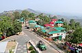 Sajek, Rangamati
 -
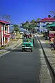 Chander Gari
 -
 Sajek at Night
 -
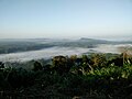 View from Sajek, Rangamati
 -
 Runmoy resort at Sajek Valley
 -
 A resort at Sajek Valley
 -
 Konglak Hill
 -
 View from Sajek Valley
 -
 Sunrise from Konglak Hill or Konglak Haphong
 -
 Road from Baghaichhari to Sajek Valley
 -
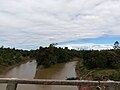 Sajek River
 -
 View from Helipad
 -
 View of Konglak Hill or Konglak Haphong
 -
 Helipad
 -
 View of Sajek Valley
 -
 View of Konglak Hill
 -
 Sajek Valley from Konglak Hill
 -
 Sunrise from Helipad
.jpg)


References edit
- ^ a b c "Sajek Valley". Beautiful Bangladesh - Bangladesh Tourism Board. Retrieved 7 March 2024.
- ^ a b "সাজেকের পাহাড় চূড়ায়" [Top of the hills at Sajek]. bdnews24.com (in Bengali). Retrieved 2024-03-06.
- ^ a b "Rangamati". Visit Bangladesh. Archived from the original on 20 May 2017.
- ^ "Sajek Valley–where hills touch the sky". The Daily Star. 15 November 2016.
- ^ a b Islam, Md Hashanat (16 April 2017). "Sajek Valley, a piece of tranquillity". The Daily Observer. Retrieved 7 March 2024.