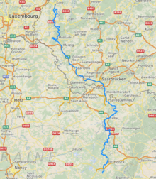
The Saar (German: [zaːɐ̯] ⓘ; French: Sarre [saʁ]) is a river in northeastern France and western Germany, and a right tributary of the Moselle. It rises in the Vosges mountains on the border of Alsace and Lorraine and flows northwards into the Moselle near Trier. It has two headstreams (the Sarre Rouge and Sarre Blanche, which join in Lorquin), that both start near Mont Donon, the highest peak of the northern Vosges. After 246 kilometres (153 mi) (129 kilometres; 80 miles in France and on the French-German border,[1] and 117 kilometres; 73 miles in Germany) the Saar flows into the Moselle at Konz (Rhineland-Palatinate) between Trier and the Luxembourg border. It has a catchment area of 7,431 square kilometres (2,869 sq mi).
| Saar | |
|---|---|
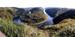
 Saar loop at Mettlach | |
 | |
| Location | |
| Countries | France and Germany |
| Physical characteristics | |
| Source | Sarre Blanche |
| • location | Vosges mountains, Bas-Rhin |
| • coordinates | 48°31′37″N 7°09′45″E / 48.52694°N 7.16250°E |
| • elevation | ±800 m (2,600 ft) |
| 2nd source | Sarre Rouge |
| • location | Vosges mountains, Moselle |
| • coordinates | 48°32′05″N 7°10′05″E / 48.53472°N 7.16806°E |
| • elevation | ±670 m (2,200 ft) |
| Mouth | |
• location | Moselle |
• coordinates | 49°42′5″N 6°34′11″E / 49.70139°N 6.56972°E |
| Length | 246 km (153 mi) |
| Basin size | 7,431 km2 (2,869 sq mi) |
| Discharge | |
| • average | 75 m3/s (2,600 cu ft/s) |
| Basin features | |
| Progression | Moselle→ Rhine→ North Sea |


The Saar flows through the following departments of France, states of Germany and towns:
- Moselle (F): Abreschviller (Sarre Rouge), Lorquin, Sarrebourg, Fénétrange
- Bas-Rhin (F): Sarre-Union
- Moselle (F): Sarralbe, Sarreguemines
- Saarland (D): Saarbrücken, Völklingen, Wadgassen, Bous, Saarlouis, Dillingen, Merzig
- Rhineland-Palatinate (D): Saarburg, Konz.

On the banks of the Saar is the UNESCO-World Heritage Site Völklinger Hütte. At Mettlach the Saar passes the well-known Saar loop. The lower Saar in Rhineland-Palatinate is a winegrowing region of some importance, producing mostly Riesling. Until the early 20th century, much more wine was grown on the banks of the Saar, reaching much further up from the mouth of the river, up to Saarbrücken. Only in the early 21st century have some enterprising farmers from the Saarland area started experimenting with winegrowing again.
The name Saar stems from the Celtic word sara (streaming water), and the Roman name of the river, saravus.
Tributaries edit
Tributaries of the Saar are, from source to mouth:[1]
- Sarre Blanche (left)
- Sarre Rouge (right)
- Bièvre (right)
- Isch (right)
- Albe (left)
- Eichel (right)
- Blies (right)
- Rohrbach (right)
- Köllerbach (right)
- Rossel (left)
- Bist (left)
- Ellbach (right)
- Prims (right)
- Nied (left)
- Leukbach (left)
edit
In 2001, the lowermost 87.2 km (54.2 mi) section from the confluence of Saar and Moselle at Konz up to the city of Saarbrücken was upgraded for navigation with Class Vb ships. Since then, goods can be transported in northbound direction, for instance, to the sea port of Rotterdam. In its middle section, the Saar had been made navigable in 1866 and was used for the transport of coal (upstream) and of iron ore (downstream) in southbound direction. The 17.5 km (10.9 mi) section between Saarbrücken and Sarreguemines is navigable for smaller Class I ships.[2] At Sarreguemines the 64 km (40 mi) Canal de la Sarre (also navigable for Class I ships) connects the Saar since 1866 with the Marne–Rhine Canal at Gondrexange.[3]
References edit
- ^ a b Sandre. "Fiche cours d'eau - La Sarre (A9--0100)".
- ^ Längen der Hauptschifffahrtswege der Binnenwasserstraßen des Bundes, Liste 4, Bundesministerium für Verkehr und digitale Infrastruktur (Federal Ministry of Transport and Digital Infrastructure)
- ^ Fluviacarte, Canal de la Sarre