| Name of object |
Location |
Coordinates |
ID |
Photo |
Upload
|
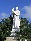
| Statue of St. Anthony of Padua |
Triq Santa Liberata |
35°53′09″N 14°31′56″E / 35.885787°N 14.532111°E / 35.885787; 14.532111 (Statue of St. Anthony of Padua) |
00648 |
 |

Upload Photo
|
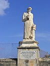
| Statue of St. Francis |
Triq Santa Liberata |
35°53′08″N 14°31′59″E / 35.885638°N 14.533006°E / 35.885638; 14.533006 (Statue of St. Francis) |
00649 |
 |
Upload Photo
|
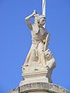
| Statue of St. Michael |
Triq Santa Liberata |
35°54′25″N 14°29′30″E / 35.906902°N 14.491629°E / 35.906902; 14.491629 (Statue of St. Michael) |
00650 |
 |
Upload Photo
|
| Church of St. Barbara and the Capuchin Friars |
Triq Santu Rokku |
35°53′08″N 14°32′00″E / 35.885634°N 14.533224°E / 35.885634; 14.533224 (Church of St. Barbara and the Capuchin Friars) |
00651 |
 |
Upload Photo
|
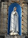
| Niche of the Madonna of Fatima |
Triq Santu Rokku / Triq Kapuċċini |
35°53′10″N 14°32′01″E / 35.885982°N 14.533611°E / 35.885982; 14.533611 (Niche of the Madonna of Fatima) |
00652 |
 |
Upload Photo
|
| Chapel of Christ the Saviour |
Triq is-Salvatur |
35°53′30″N 14°31′32″E / 35.891566°N 14.525463°E / 35.891566; 14.525463 (Chapel of Christ the Saviour) |
00653 |
 |
Upload Photo
|
| Niche of the Madonna of Loreto |
83 Triq ir-Rinella / Triq Patist Borda |
35°53′25″N 14°31′37″E / 35.890317°N 14.526807°E / 35.890317; 14.526807 (Niche of the Madonna of Loreto) |
00654 |
 |
Upload Photo
|
| Niche of St Joseph |
Triq ir-Rinella / Triq is-Sienja |
35°53′25″N 14°31′37″E / 35.890344°N 14.526919°E / 35.890344; 14.526919 (Niche of St Joseph) |
00655 |
 |
Upload Photo
|
| Niche of Saint Philomena |
4 Triq Santa Filumena |
35°53′20″N 14°31′44″E / 35.888887°N 14.528812°E / 35.888887; 14.528812 (Niche of Saint Philomena) |
00656 |
 |
Upload Photo
|
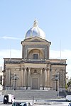
| Parish Church of St. Joseph |
Misraħ l-Arċisqof Gonzi |
35°53′18″N 14°31′44″E / 35.888415°N 14.528828°E / 35.888415; 14.528828 (Parish Church of St. Joseph) |
00657 |
 |
Upload Photo
|
| Niche of St. Theresa of Avila |
Sqaq l-Ixprunara |
35°53′17″N 14°31′39″E / 35.888054°N 14.527457°E / 35.888054; 14.527457 (Niche of St. Theresa of Avila) |
00658 |
 |
Upload Photo
|
| The Cottage |
Triq Marina |
35°53′25″N 14°31′33″E / 35.890172°N 14.525757°E / 35.890172; 14.525757 (The Cottage) |
01172 |
 |
Upload Photo
|
| Villa Portelli |
Triq Marina |
35°53′26″N 14°31′32″E / 35.890550°N 14.525634°E / 35.890550; 14.525634 (Villa Portelli) |
01173 |
 |
Upload Photo
|
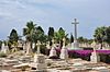
| Kalkara Naval Cemetery |
Triq San Leonardu |
5°53′14″N 14°32′12″E / 5.887118°N 14.536686°E / 5.887118; 14.536686 (Kalkara Naval Cemetery) |
01174 |
|
Upload Photo
|
| Red House |
Triq Santu Rokku / Sqaq Tewma |
35°53′25″N 14°32′10″E / 35.890206°N 14.536047°E / 35.890206; 14.536047 (Red House) |
01175 |
 |
Upload Photo
|
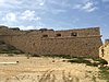
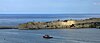
| Fort Ricasoli |
Gallows’ Point |
35°53′50″N 14°31′36″E / 35.897174°N 14.526713°E / 35.897174; 14.526713 (Fort Ricasoli) |
01655 |
|
Upload Photo
|
| Central Bastion |
Fort Ricasoli |
35°53′45″N 14°31′42″E / 35.895905°N 14.528470°E / 35.895905; 14.528470 (Central Bastion) |
01656 |
|
Upload Photo
|
| Right Demi-Bastion |
Fort Ricasoli |
35°53′45″N 14°31′38″E / 35.895697°N 14.527343°E / 35.895697; 14.527343 (Right Demi-Bastion) |
01657 |
 |
Upload Photo
|
| Left Demi-Bastion |
Fort Ricasoli |
35°53′49″N 14°31′43″E / 35.896904°N 14.528550°E / 35.896904; 14.528550 (Left Demi-Bastion) |
01658 |
 |
Upload Photo
|
| Faussebarye |
Fort Ricasoli |
35°53′44″N 14°31′41″E / 35.895593°N 14.528001°E / 35.895593; 14.528001 (Faussebarye) |
01659 |
|
Upload Photo
|
| Counterguard |
Fort Ricasoli |
35°53′50″N 14°31′48″E / 35.897223°N 14.529865°E / 35.897223; 14.529865 (Counterguard) |
01660 |
 |
Upload Photo
|
| Sally-port |
Fort Ricasoli |
35°53′47″N 14°31′43″E / 35.896483°N 14.528666°E / 35.896483; 14.528666 (Sally-port) |
01661 |
|
Upload Photo
|
| Sally-port |
Fort Ricasoli |
35°53′44″N 14°31′40″E / 35.895581°N 14.527741°E / 35.895581; 14.527741 (Sally-port) |
01662 |
|
Upload Photo
|
| Right Caponier |
Fort Ricasoli |
35°53′44″N 14°31′40″E / 35.895418°N 14.527819°E / 35.895418; 14.527819 (Right Caponier) |
01663 |
|
Upload Photo
|
| Left Caponier |
Fort Ricasoli |
35°53′47″N 14°31′44″E / 35.896461°N 14.528919°E / 35.896461; 14.528919 (Left Caponier) |
01664 |
|
Upload Photo
|
| Right Ravelin |
Fort Ricasoli |
35°53′42″N 14°31′41″E / 35.895016°N 14.528018°E / 35.895016; 14.528018 (Right Ravelin) |
01665 |
|
Upload Photo
|
| Left Ravelin |
Fort Ricasoli |
35°53′47″N 14°31′46″E / 35.896439°N 14.529438°E / 35.896439; 14.529438 (Left Ravelin) |
01666 |
 |
Upload Photo
|
| Covertway |
Fort Ricasoli |
35°53′43″N 14°31′46″E / 35.895344°N 14.529322°E / 35.895344; 14.529322 (Covertway) |
01667 |
 |
Upload Photo
|
| Glacis |
Fort Ricasoli |
35°53′42″N 14°31′47″E / 35.895106°N 14.529752°E / 35.895106; 14.529752 (Glacis) |
01668 |
|
Upload Photo
|
| Land front ditch |
Fort Ricasoli |
35°53′44″N 14°31′42″E / 35.895445°N 14.528456°E / 35.895445; 14.528456 (Land front ditch) |
01669 |
|
Upload Photo
|
| Sea front ditch |
Fort Ricasoli |
35°53′54″N 14°31′33″E / 35.898278°N 14.525763°E / 35.898278; 14.525763 (Sea front ditch) |
01670 |
|
Upload Photo
|
| No 1 Bastion and Tenaille |
Fort Ricasoli |
35°53′55″N 14°31′27″E / 35.898479°N 14.524088°E / 35.898479; 14.524088 (No 1 Bastion and Tenaille) |
01671 |
|
Upload Photo
|
| No 1 Curtain |
Fort Ricasoli |
35°53′54″N 14°31′29″E / 35.898414°N 14.524628°E / 35.898414; 14.524628 (No 1 Curtain) |
01672 |
|
Upload Photo
|
| No. 2 Bastion |
Fort Ricasoli |
35°53′55″N 14°31′31″E / 35.898640°N 14.525245°E / 35.898640; 14.525245 (No. 2 Bastion) |
01673 |
|
Upload Photo
|
| No.2 Curtain |
Fort Ricasoli |
35°53′53″N 14°31′33″E / 35.898092°N 14.525846°E / 35.898092; 14.525846 (No.2 Curtain) |
01674 |
|
Upload Photo
|
| No. 3 Bastion |
Fort Ricasoli |
35°53′53″N 14°31′36″E / 35.898040°N 14.526538°E / 35.898040; 14.526538 (No. 3 Bastion) |
01675 |
|
Upload Photo
|
| Platform near No 3 Bastion |
Fort Ricasoli |
35°53′52″N 14°31′38″E / 35.897684°N 14.527178°E / 35.897684; 14.527178 (Platform near No 3 Bastion) |
01676 |
|
Upload Photo
|
| Curtain near No.4 Bastion |
Fort Ricasoli |
35°53′51″N 14°31′41″E / 35.897556°N 14.528146°E / 35.897556; 14.528146 (Curtain near No.4 Bastion) |
01677 |
|
Upload Photo
|
| No 4 Bastion |
Fort Ricasoli |
35°53′52″N 14°31′43″E / 35.897832°N 14.528568°E / 35.897832; 14.528568 (No 4 Bastion) |
01678 |
 |
Upload Photo
|
| No 5 Curtain |
Fort Ricasoli |
35°53′50″N 14°31′43″E / 35.897354°N 14.528595°E / 35.897354; 14.528595 (No 5 Curtain) |
01679 |
|
Upload Photo
|
| Harbour tenaille trace |
Fort Ricasoli |
35°53′49″N 14°31′32″E / 35.896976°N 14.525575°E / 35.896976; 14.525575 (Harbour tenaille trace) |
01680 |
 |
Upload Photo
|
| Orsi Battery remains |
Fort Ricasoli |
35°53′54″N 14°31′25″E / 35.898258°N 14.523687°E / 35.898258; 14.523687 (Orsi Battery remains) |
01681 |
|
Upload Photo
|
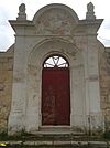
| Main Gate and remains of Governor's House |
Fort Ricasoli |
35°53′46″N 14°31′36″E / 35.896188°N 14.526615°E / 35.896188; 14.526615 (Main Gate and remains of Governor's House) |
01682 |
 |
Upload Photo
|
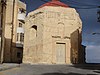
| Chapel of St Nicholas |
Fort Ricasoli |
35°53′48″N 14°31′36″E / 35.896557°N 14.526774°E / 35.896557; 14.526774 (Chapel of St Nicholas) |
01683 |
|
Upload Photo
|
| Gunpowder magazine 1 |
Fort Ricasoli |
35°53′50″N 14°31′43″E / 35.897165°N 14.528624°E / 35.897165; 14.528624 (Gunpowder magazine 1) |
01684 |
|
Upload Photo
|
| Gunpowder magazine 2 |
Fort Ricasoli |
35°53′51″N 14°31′37″E / 35.897598°N 14.527022°E / 35.897598; 14.527022 (Gunpowder magazine 2) |
01685 |
|
Upload Photo
|


.jpg)


.jpg)


