
Size of this preview: 600 × 600 pixels. Other resolutions: 240 × 240 pixels | 480 × 480 pixels | 700 × 700 pixels.
Original file (700 × 700 pixels, file size: 40 KB, MIME type: image/gif)
| This is a file from the Wikimedia Commons. Information from its description page there is shown below. Commons is a freely licensed media file repository. You can help. |
Summary
| Description |
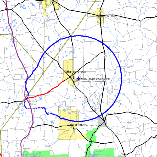
WRSK Service Area - Contour Map http://www.fcc.gov/fcc-bin/FMTV-service-area?x=FM159274.html Source FCC database |
| Source | |
| Author | See below |
Licensing
| This image is a work of the Federal Communications Commission, taken or made as part of that person's official duties. As a work of the U.S. federal government, the image is in the public domain in the United States. | 
|
Original upload log
The original description page was here. All following user names refer to en.wikipedia.
| Date/Time | Dimensions | User | Comment |
|---|---|---|---|
| 2006-03-16 20:41:38 | 700× 700× | Beatgr | WRSK Service Area - Contour Map http://www.fcc.gov/fcc-bin/FMTV-service-area?x=FM159274.html Source FCC database |
File history
Click on a date/time to view the file as it appeared at that time.
| Date/Time | Thumbnail | Dimensions | User | Comment | |
|---|---|---|---|---|---|
| current | 08:42, 17 January 2017 | | 700 × 700 (40 KB) | FastilyClone | Transferred from en.wikipedia (MTC!) |
File usage
The following pages on the English Wikipedia use this file (pages on other projects are not listed):