File:South and east elevations, photographed from slightly more western position - Sacramento City Hall, 915 I Street, Sacramento, Sacramento County, CA HABS CAL,34-SAC,48-2.tif

Size of this JPG preview of this TIF file: 753 × 600 pixels. Other resolutions: 301 × 240 pixels | 603 × 480 pixels | 964 × 768 pixels | 1,280 × 1,020 pixels | 2,560 × 2,039 pixels | 4,971 × 3,960 pixels.
Original file (4,971 × 3,960 pixels, file size: 18.78 MB, MIME type: image/tiff)
| This is a file from the Wikimedia Commons. Information from its description page there is shown below. Commons is a freely licensed media file repository. You can help. |
Summary
| South and east elevations, photographed from slightly more western position - Sacramento City Hall, 915 I Street, Sacramento, Sacramento County, CA | ||||
|---|---|---|---|---|
| Title |
South and east elevations, photographed from slightly more western position - Sacramento City Hall, 915 I Street, Sacramento, Sacramento County, CA |
|||
| Depicted place | California; Sacramento County; Sacramento | |||
| Date | 1981 | |||
| Dimensions | 4 x 5 in. | |||
| Current location |
Library of Congress Prints and Photographs Division Washington, D.C. 20540 USA http://hdl.loc.gov/loc.pnp/pp.print |
|||
| Accession number |
HABS CAL,34-SAC,48-2 |
|||
| Credit line |
|
|||
| Source | https://www.loc.gov/pictures/item/ca1298.photos.014732p | |||
| Permission (Reusing this file) |
|
|||

| Camera location | | View this and other nearby images on: OpenStreetMap |
|---|
File history
Click on a date/time to view the file as it appeared at that time.
| Date/Time | Thumbnail | Dimensions | User | Comment | |
|---|---|---|---|---|---|
| current | 20:25, 2 July 2014 | 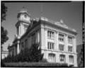 | 4,971 × 3,960 (18.78 MB) | Fæ | GWToolset: Creating mediafile for Fæ. HABS batch upload 2 July 2014 (301:400) |
File usage
The following pages on the English Wikipedia use this file (pages on other projects are not listed):
Global file usage
The following other wikis use this file:
- Usage on es.wikipedia.org