No higher resolution available.
Mount_Panorama_Circuit_Map_Overview.PNG (443 × 599 pixels, file size: 82 KB, MIME type: image/png)
| This is a file from the Wikimedia Commons. Information from its description page there is shown below. Commons is a freely licensed media file repository. You can help. |
Summary

|
This road map image could be re-created using vector graphics as an SVG file. This has several advantages; see Commons:Media for cleanup for more information. If an SVG form of this image is available, please upload it and afterwards replace this template with
{{vector version available|new image name}}.
It is recommended to name the SVG file “Mount Panorama Circuit Map Overview.svg”—then the template Vector version available (or Vva) does not need the new image name parameter. |
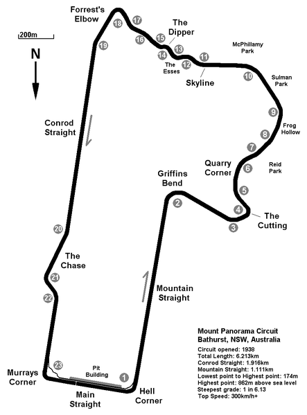
| Description | A basic overview map of the Mount Panorama Circuit in Bathurst, NSW, Australia. Map made by myself October 2008 - October 2009. |
| Date | 11 October 2009 (original upload date) |
| Source |
Own work Transferred from en.wikipedia |
| Author | Nick carson at en.wikipedia |
Licensing
Nick carson at en.wikipedia, the copyright holder of this work, hereby publishes it under the following license:
This file is licensed under the Creative Commons Attribution 3.0 Unported license.
Attribution: Nick carson at en.wikipedia
- You are free:
- to share – to copy, distribute and transmit the work
- to remix – to adapt the work
- Under the following conditions:
- attribution – You must give appropriate credit, provide a link to the license, and indicate if changes were made. You may do so in any reasonable manner, but not in any way that suggests the licensor endorses you or your use.
Original upload log
The original description page was here. All following user names refer to en.wikipedia.
- 2009-10-11 03:44 Nick carson 874×1182 (52602 bytes) A basic overview map of the Mount Panorama Circuit in Bathurst, NSW, Australia. Map made by myself October 2008 - October 2009.
- 2010-09-28 04:29 Abbaskip 443×599 (83882 bytes) Griffins Bend was incorrectly titled quarry corner.
File history
Click on a date/time to view the file as it appeared at that time.
| Date/Time | Thumbnail | Dimensions | User | Comment | |
|---|---|---|---|---|---|
| current | 18:45, 7 January 2012 | | 443 × 599 (82 KB) | BotMultichillT | {{BotMoveToCommons|en.wikipedia|year={{subst:CURRENTYEAR}}|month={{subst:CURRENTMONTHNAME}}|day={{subst:CURRENTDAY}}}} == {{int:filedesc}} == {{Information |description={{en|1={{Template:ShouldBeSVG}} A basic overview map of the Mount Panorama Circuit |
File usage
The following pages on the English Wikipedia use this file (pages on other projects are not listed):
- 1987 James Hardie 1000
- 1995 Bathurst ATCC round
- 1999 FAI 1000
- 2000 FAI 1000
- 2001 V8 Supercar 1000
- 2002 Bob Jane T-Marts 1000
- 2003 Bob Jane T-Marts 1000
- 2004 Bob Jane T-Marts 1000
- 2005 Supercheap Auto 1000
- 2006 Supercheap Auto Bathurst 1000
- 2007 Supercheap Auto Bathurst 1000
- 2008 Supercheap Auto Bathurst 1000
- 2009 Supercheap Auto Bathurst 1000
- 2010 Supercheap Auto Bathurst 1000
- 2011 Supercheap Auto Bathurst 1000
- 2012 Supercheap Auto Bathurst 1000
- 2013 Supercheap Auto Bathurst 1000
- 2014 Bathurst 1000
- 2015 Bathurst 1000
- 2016 Bathurst 1000
- 2023 Bathurst 1000
- 2023 Bathurst 12 Hour
- 2023 Bathurst International
- 2024 Bathurst 12 Hour
- 2024 Bathurst 500
- Australian Tourist Trophy
- Bathurst 12 Hour
- Bathurst 250
- Bathurst Motor Festival
- Mount Panorama 500
- Mount Panorama Circuit
- User:Nick carson/uploaded photos
Global file usage
The following other wikis use this file:
- Usage on de.wikipedia.org
- Usage on fi.wikipedia.org
- Usage on hu.wikipedia.org
- Usage on id.wikipedia.org
- Usage on ja.wikipedia.org
- Usage on pl.wikipedia.org
- Usage on pt.wikipedia.org
- Usage on sk.wikipedia.org
- Usage on sv.wikipedia.org
- Usage on zh.wikipedia.org