
Size of this preview: 800 × 534 pixels. Other resolutions: 320 × 213 pixels | 640 × 427 pixels | 1,024 × 683 pixels.
Original file (1,024 × 683 pixels, file size: 468 KB, MIME type: image/jpeg)
| This is a file from the Wikimedia Commons. Information from its description page there is shown below. Commons is a freely licensed media file repository. You can help. |
Summary
| Description |
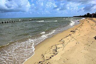
English: Some serious coastal erosion at Monkey River Village. The beach used to be all the way over to left of the photograph. Gravel mining upstream has depleted the sediment load of Monkey River. The result is less deposition in coastal areas such as this.
LicensingThis file is licensed under the Creative Commons Attribution 2.0 Generic license.
|
||||||
| Date | |||||||
| Source | (Original text: Monkey River Beach) | ||||||
| Author | Chris H from England |
Licensing
| This image was originally posted to Flickr by Kríttik'l Kápchər (CH) at https://www.flickr.com/photos/88029159@N00/4811173650. It was reviewed on 12 March 2013 by FlickreviewR and was confirmed to be licensed under the terms of the cc-by-2.0. |
This file is licensed under the Creative Commons Attribution 2.0 Generic license.
- You are free:
- to share – to copy, distribute and transmit the work
- to remix – to adapt the work
- Under the following conditions:
- attribution – You must give appropriate credit, provide a link to the license, and indicate if changes were made. You may do so in any reasonable manner, but not in any way that suggests the licensor endorses you or your use.
File history
Click on a date/time to view the file as it appeared at that time.
| Date/Time | Thumbnail | Dimensions | User | Comment | |
|---|---|---|---|---|---|
| current | 19:24, 12 March 2013 | | 1,024 × 683 (468 KB) | Pgbk1987 | User created page with UploadWizard |
File usage
The following pages on the English Wikipedia use this file (pages on other projects are not listed):
Global file usage
The following other wikis use this file:
- Usage on ca.wikipedia.org
- Usage on ceb.wikipedia.org
- Usage on en.wikivoyage.org
- Usage on es.wikipedia.org
- Usage on hr.wikipedia.org
- Usage on it.wikivoyage.org
- Usage on nds.wikipedia.org
- Usage on pl.wikipedia.org
- Usage on ru.wikipedia.org
- Usage on sv.wikipedia.org
- Usage on ur.wikipedia.org
- Usage on www.wikidata.org