Size of this preview: 597 × 600 pixels. Other resolutions: 239 × 240 pixels | 478 × 480 pixels | 764 × 768 pixels | 1,019 × 1,024 pixels | 1,800 × 1,809 pixels.
Original file (1,800 × 1,809 pixels, file size: 1.55 MB, MIME type: image/jpeg)
File history
Click on a date/time to view the file as it appeared at that time.
| Date/Time | Thumbnail | Dimensions | User | Comment | |
|---|---|---|---|---|---|
| current | 20:43, 10 January 2010 |  | 1,800 × 1,809 (1.55 MB) | Entheta | contrast. slight crop |
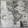
| 18:40, 6 May 2005 |  | 1,830 × 1,840 (1.8 MB) | Manuel González Olaechea | Map of America; ca. 1770. {{GFDL}} |
File usage
No pages on the English Wikipedia use this file (pages on other projects are not listed).
Global file usage
The following other wikis use this file:
- Usage on ar.wikipedia.org
- Usage on ca.wikipedia.org
- Usage on es.wikipedia.org
- Anexo:Ciudad de Pisco en los mapas históricos
- Usuario:Manuel González Olaechea y Franco/Galería de imágenes
- Historia territorial del Perú
- Discusión:Fronteras de Chile
- Usuario:Yakoo/Origen del término Pisco
- Usuario:Hispalois/mapas antiguos
- Usuario:Manuel González Olaechea y Franco/Galería de mapas de América
- Usage on es.wikinews.org
- Usage on fr.wikipedia.org
- Usage on kn.wikipedia.org
- Usage on lo.wikipedia.org
- Usage on pcd.wikipedia.org
- Usage on th.wikipedia.org
- Usage on vi.wikipedia.org