
Size of this preview: 600 × 600 pixels. Other resolutions: 240 × 240 pixels | 480 × 480 pixels | 768 × 768 pixels | 1,024 × 1,024 pixels | 2,362 × 2,362 pixels.
Original file (2,362 × 2,362 pixels, file size: 2.04 MB, MIME type: image/gif, 0.0 s)
| This is a file from the Wikimedia Commons. Information from its description page there is shown below. Commons is a freely licensed media file repository. You can help. |
Summary
| Description |
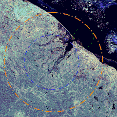
Русский: Изображение Карской метеоритной структуры, синтезированное из сюжетов, полученных спутником Landsat 7. Желтая окружность изображает диаметр кратера в предположении о его 120-ти километровом размере, синяя и зеленая окружности соответствуют диаметрам 60-ти и 22-ух километровых кратеров. Кратерная воронка на снимке выражена неотчетливо, хотя по границам впадины прослеживается окаймление, выраженное теплыми фототонами.
English: Image of the Kara meteor structure in the Yugorsky Peninsula, Nenetsia, Russia. This is a composite from images obtained by Landsat 7. The yellow circle indicates the crater on the presumption of its diameter of 120 km; the blue and green of diameter 60 and 22 km, respectively. The crater is not clearly distinguishable on the photo; however, the boundary of the depression can be traced by warmer hues. |
| Date | Unknown date |
| Source | http://www.meteorites.ru/menu/encyclopaedia/ruscraters_full.html |
| Author | NASA |
Licensing
| This file is in the public domain in the United States because it was solely created by NASA. NASA copyright policy states that "NASA material is not protected by copyright unless noted". (See Template:PD-USGov, NASA copyright policy page or JPL Image Use Policy.) | ||
 |
Warnings:
|
File history
Click on a date/time to view the file as it appeared at that time.
| Date/Time | Thumbnail | Dimensions | User | Comment | |
|---|---|---|---|---|---|
| current | 17:58, 2 June 2010 | | 2,362 × 2,362 (2.04 MB) | JukoFF | == Summary == {{Information |Description={{ru|1=Карской метеоритной структуры синтезированное из сюжетов, полученных спутником Landsat 7. Желтая окружность изобра� |
File usage
The following pages on the English Wikipedia use this file (pages on other projects are not listed):
Global file usage
The following other wikis use this file:
- Usage on cs.wikipedia.org
- Usage on fa.wikipedia.org
- Usage on fr.wikipedia.org
- Usage on it.wikipedia.org
- Usage on nl.wikipedia.org
- Usage on pl.wikipedia.org
- Usage on ro.wikipedia.org
- Usage on ru.wikipedia.org
- Usage on uk.wikipedia.org
- Usage on www.wikidata.org
- Usage on zh.wikipedia.org