No higher resolution available.
Holt_Heath_and_Forest_Dorset_-_geograph.org.uk_-_1060816.jpg (640 × 438 pixels, file size: 96 KB, MIME type: image/jpeg)
| This is a file from the Wikimedia Commons. Information from its description page there is shown below. Commons is a freely licensed media file repository. You can help. |
Summary
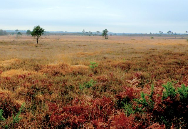
| Description |
English: Holt Heath and Forest Dorset View across the north side of the heath from close to the road from Mannington to Holt. This is one of the largest tracts of heathland left in Dorset, now owned by the national Trust. Only 15 per cent of the original acreage of this rare habitat now remains in Dorset. It is also a Nature reserve. Originally the local commoners' practice of grazing stock and gathering firewood kept the heath in this condition. Nowadays this has to be done artificially to preserve the heath and it rare flora and fauna. Thomas Hardy made this kind of heathland famous in his books such as Return of the Native |
| Date | |
| Source | From geograph.org.uk |
| Author | Nigel Mykura |
| Attribution (required by the license) | Nigel Mykura / Holt Heath and Forest Dorset / |
| Camera location | | View this and other nearby images on: OpenStreetMap |
|---|
_heading:135.00&language=en)
| Object location | | View this and other nearby images on: OpenStreetMap |
|---|
_heading:135.00&language=en)
Licensing

|
This image was taken from the Geograph project collection. See this photograph's page on the Geograph website for the photographer's contact details. The copyright on this image is owned by Nigel Mykura and is licensed for reuse under the Creative Commons Attribution-ShareAlike 2.0 license.
|
This file is licensed under the Creative Commons Attribution-Share Alike 2.0 Generic license.
Attribution: Nigel Mykura
- You are free:
- to share – to copy, distribute and transmit the work
- to remix – to adapt the work
- Under the following conditions:
- attribution – You must give appropriate credit, provide a link to the license, and indicate if changes were made. You may do so in any reasonable manner, but not in any way that suggests the licensor endorses you or your use.
- share alike – If you remix, transform, or build upon the material, you must distribute your contributions under the same or compatible license as the original.
File history
Click on a date/time to view the file as it appeared at that time.
| Date/Time | Thumbnail | Dimensions | User | Comment | |
|---|---|---|---|---|---|
| current | 04:17, 24 February 2011 | | 640 × 438 (96 KB) | GeographBot | == {{int:filedesc}} == {{Information |description={{en|1=Holt Heath and Forest Dorset View across the north side of the heath from close to the road from Mannington to Holt. This is one of the largest tracts of heathland left in Dorset, now owned by the |
File usage
The following pages on the English Wikipedia use this file (pages on other projects are not listed):