No higher resolution available.
Hawker's_Hut,_Vicarage_Cliff,_Morwenstow_-_geograph.org.uk_-_1369016.jpg (640 × 480 pixels, file size: 171 KB, MIME type: image/jpeg)
| This is a file from the Wikimedia Commons. Information from its description page there is shown below. Commons is a freely licensed media file repository. You can help. |
Summary
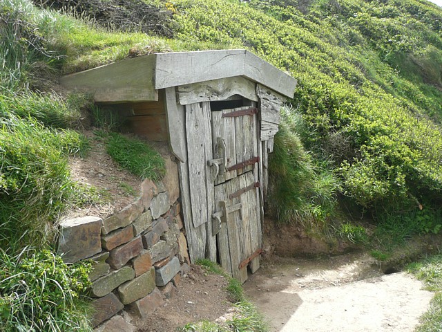
| Description |
English: Hawker's Hut, Vicarage Cliff, Morwenstow Vicarage Cliff is 137m high, of sandstone and shales. Hawker's Hut (National Trust), built from driftwood, is on a ledge just below the cliff top, overlooking the sea. The Rev. Robert Stephen Hawker was vicar of Morwenstow from 1834 until his death in 1875. He was one of the best minor poets of the Victorian age, particularly as a ballad writer, e.g. 'The Song of the Western Men'. The 'Well of St. Morwenna' was also built by Hawker. |
| Date | |
| Source | From geograph.org.uk |
| Author | Humphrey Bolton |
| Attribution (required by the license) | Humphrey Bolton / Hawker's Hut, Vicarage Cliff, Morwenstow / |
| Camera location | | View this and other nearby images on: OpenStreetMap |
|---|
_heading:135.00&language=en)
| Object location | | View this and other nearby images on: OpenStreetMap |
|---|
_heading:135.00&language=en)
Licensing

|
This image was taken from the Geograph project collection. See this photograph's page on the Geograph website for the photographer's contact details. The copyright on this image is owned by Humphrey Bolton and is licensed for reuse under the Creative Commons Attribution-ShareAlike 2.0 license.
|
This file is licensed under the Creative Commons Attribution-Share Alike 2.0 Generic license.
Attribution: Humphrey Bolton
- You are free:
- to share – to copy, distribute and transmit the work
- to remix – to adapt the work
- Under the following conditions:
- attribution – You must give appropriate credit, provide a link to the license, and indicate if changes were made. You may do so in any reasonable manner, but not in any way that suggests the licensor endorses you or your use.
- share alike – If you remix, transform, or build upon the material, you must distribute your contributions under the same or compatible license as the original.
File history
Click on a date/time to view the file as it appeared at that time.
| Date/Time | Thumbnail | Dimensions | User | Comment | |
|---|---|---|---|---|---|
| current | 11:22, 28 February 2011 | | 640 × 480 (171 KB) | GeographBot | == {{int:filedesc}} == {{Information |description={{en|1=Hawker's Hut, Vicarage Cliff, Morwenstow Vicarage Cliff is 137m high, of sandstone and shales. Hawker's Hut (National Trust), built from driftwood, is on a ledge just below the cliff top, overlooki |
File usage
The following pages on the English Wikipedia use this file (pages on other projects are not listed):
Global file usage
The following other wikis use this file:
- Usage on fr.wikipedia.org
- Usage on pl.wikipedia.org