
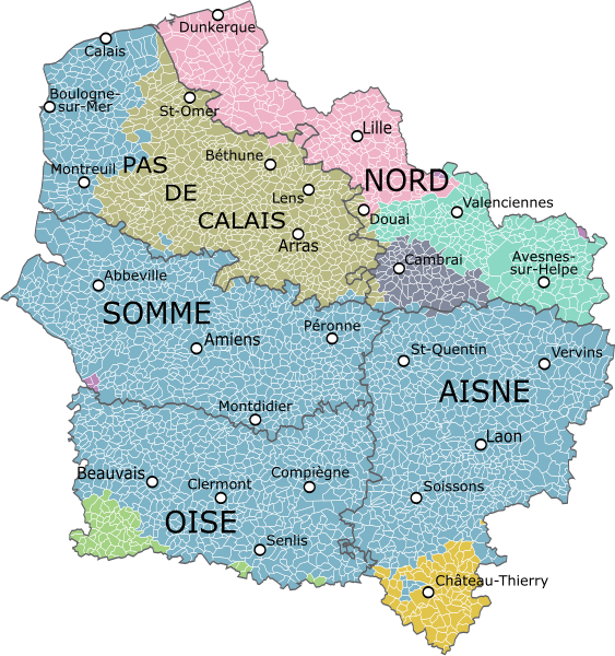
Size of this PNG preview of this SVG file: 563 × 600 pixels. Other resolutions: 225 × 240 pixels | 451 × 480 pixels | 721 × 768 pixels | 962 × 1,024 pixels | 1,923 × 2,048 pixels | 1,417 × 1,509 pixels.
Original file (SVG file, nominally 1,417 × 1,509 pixels, file size: 1.89 MB)
| This is a file from the Wikimedia Commons. Information from its description page there is shown below. Commons is a freely licensed media file repository. You can help. |
Summary
| Description |
|
|||
| Date | ||||
| Source | La Province de Picardie, divisée en haute et basse Picardie, et subdivisée en divers pays, Jean-Baptiste Nolin, 1694 ; Petite histoire de Picardie, Auguste Janvier, 1880-1884 ; Carte de la Picardie, Artois, Boulonnais, Flandre française, Hainaut et Cambrésis..., Éd. Bourgoin (Paris), 1774 ; Gouvernement général de Picardie et Artois, qui comprend le Comté d'Artois, le Ponthieu l'Amienois, le Santerre, le Vermandois et le Thierrache : Gouvernemens généraux du Boulenois et de la Flandre françoise, Robert de Vaugondy, 1753 ; Gouvernement général de l'Isle de France divisé par pays, Robert de Vaugondy, 1754.Derivative works of this file: Blank map of France, with communes and departments.svg by Poulpy | |||
| Author | Oie blanche |
Licensing
I, the copyright holder of this work, hereby publish it under the following license:
This file is licensed under the Creative Commons Attribution-Share Alike 4.0 International license.
- You are free:
- to share – to copy, distribute and transmit the work
- to remix – to adapt the work
- Under the following conditions:
- attribution – You must give appropriate credit, provide a link to the license, and indicate if changes were made. You may do so in any reasonable manner, but not in any way that suggests the licensor endorses you or your use.
- share alike – If you remix, transform, or build upon the material, you must distribute your contributions under the same or compatible license as the original.
File history
Click on a date/time to view the file as it appeared at that time.
| Date/Time | Thumbnail | Dimensions | User | Comment | |
|---|---|---|---|---|---|
| current | 17:34, 10 May 2023 | | 1,417 × 1,509 (1.89 MB) | Vaulxnoy | Corrections de la carte, la province de Picardie est bien plus large, Hesdin est bien en Artois et non en Picardie. |
| 00:50, 7 September 2015 |  | 1,417 × 1,509 (1.92 MB) | Oie blanche | User created page with UploadWizard |
File usage
The following pages on the English Wikipedia use this file (pages on other projects are not listed):
Global file usage
The following other wikis use this file:
- Usage on als.wikipedia.org
- Usage on ast.wikipedia.org
- Usage on de.wikivoyage.org
- Usage on es.wikipedia.org
- Usage on et.wikipedia.org
- Usage on fr.wikipedia.org
- Usage on gl.wikipedia.org
- Usage on he.wikipedia.org
- Usage on hr.wikipedia.org
- Usage on id.wikipedia.org
- Usage on it.wikipedia.org
- Usage on ja.wikipedia.org
- Usage on ku.wikipedia.org
- Usage on la.wikipedia.org
- Usage on nds-nl.wikipedia.org
- Usage on nl.wikipedia.org
- Usage on pt.wikipedia.org
- Usage on ro.wikipedia.org
- Usage on sh.wikipedia.org
- Usage on sl.wikipedia.org
- Usage on sq.wikipedia.org
- Usage on vi.wikipedia.org
- Usage on vls.wikipedia.org
- Usage on zh.wikipedia.org