
Size of this PNG preview of this SVG file: 512 × 288 pixels. Other resolutions: 320 × 180 pixels | 640 × 360 pixels | 1,024 × 576 pixels | 1,280 × 720 pixels | 2,560 × 1,440 pixels.
Original file (SVG file, nominally 512 × 288 pixels, file size: 196 KB)
| This is a file from the Wikimedia Commons. Information from its description page there is shown below. Commons is a freely licensed media file repository. You can help. |
Summary
| Description |
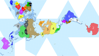
English: Dymaxion map of the world by visionscarto on http://visionscarto.net/public/fonds-de-cartes-en/visionscarto-airocean.svg with the 30 largest countries and territories by total area according to the CIA World Factbook at http://cia.gov/the-world-factbook/field/area/country-comparison roughly to scale highlighted by CMG Lee. |
|||
| Date | ||||
| Source |
|
|||
| Author | cmglee, Philippe Rivière | |||
| Other versions |
|


Licensing
This file is licensed under the Creative Commons Attribution-Share Alike 4.0 International license.
- You are free:
- to share – to copy, distribute and transmit the work
- to remix – to adapt the work
- Under the following conditions:
- attribution – You must give appropriate credit, provide a link to the license, and indicate if changes were made. You may do so in any reasonable manner, but not in any way that suggests the licensor endorses you or your use.
- share alike – If you remix, transform, or build upon the material, you must distribute your contributions under the same or compatible license as the original.
File history
Click on a date/time to view the file as it appeared at that time.
| Date/Time | Thumbnail | Dimensions | User | Comment | |
|---|---|---|---|---|---|
| current | 21:30, 15 February 2021 | | 512 × 288 (196 KB) | Cmglee | {{Information |Description=Dymaxion map of the world by visionscarto on http://visionscarto.net/public/fonds-de-cartes-en/visionscarto-airocean.svg with the 30 largest countries and territories by total area according to the CIA World Factbook at http://cia.gov/the-world-factbook/field/area/country-comparison roughly to scale highlighted by CMG Lee. |Source={{own}} |Date= |Author= Cmglee |Permission= |other_versions={{source thumb|Fuller_projection_with_largest_countries.svg}}... |
File usage
The following pages on the English Wikipedia use this file (pages on other projects are not listed):