File:Cambridge free tennis courts.svg

Original file (SVG file, nominally 512 × 419 pixels, file size: 340 KB)

Summary

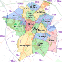
Description Cambridge City Council free-to-use tennis courts as listed on http://cambridge.gov.uk/tennis with numbers denoting the number of courts at each location.
Date 21 April 2014, 17:10:52
Source
Cambridge UK ward map 2010 coloured on Cambridge-Openstreetmap-08-06-13.svg
Author Nilfanion, created using Ordnance Survey data, derivative work by Maxxl2, OpenStreetMap and cmglee

Licensing

w:en:Creative Commons
attribution share alike
This file is licensed under the Creative Commons Attribution-Share Alike 3.0 Unported license.
You are free:
  • to share – to copy, distribute and transmit the work
  • to remix – to adapt the work
Under the following conditions:
  • attribution – You must give appropriate credit, provide a link to the license, and indicate if changes were made. You may do so in any reasonable manner, but not in any way that suggests the licensor endorses you or your use.
  • share alike – If you remix, transform, or build upon the material, you must distribute your contributions under the same or compatible license as the original.

Captions

Add a one-line explanation of what this file represents

Items portrayed in this file

depicts

image/svg+xml

a5efc11483bcb656c43c3e99b6b733701d47abe8

347,734 byte

419 pixel

512 pixel

File history

Click on a date/time to view the file as it appeared at that time.

Date/TimeThumbnailDimensionsUserComment
current00:13, 11 September 2018Thumbnail for version as of 00:13, 11 September 2018512 × 419 (340 KB)CmgleeSmooth-shade ward boundaries.
22:40, 10 September 2018Thumbnail for version as of 22:40, 10 September 2018512 × 419 (339 KB)Cmglee{{Information |description=Cambridge City Council free-to-use tennis courts as listed on http://cambridge.gov.uk/tennis . |date=21 April 2014, 17:10:52 |source={{source thumb|Cambridge_UK_ward_map_2010_coloured_on_Cambridge-Openstreetmap-08-06-13.svg}} |author=Nilfanion, created using Ordnance Survey data, derivative work by Maxxl2, OpenStreetMap and cmglee |permission= |other versions= }} Category:Maps of Cambridge

Global file usage

The following other wikis use this file:
Metadata