No higher resolution available.
Burnt_Ash_marked.JPG (264 × 440 pixels, file size: 39 KB, MIME type: image/jpeg)
| This is a file from the Wikimedia Commons. Information from its description page there is shown below. Commons is a freely licensed media file repository. You can help. |
Summary
| Description |
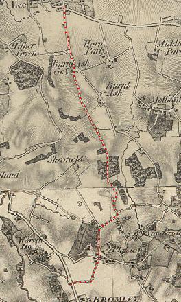
English: Section of OS map published in 1841, showing Burnt Ash and the surrounding area. |
| Source | Image of OS map, with marking added by Carlwev |
| Author | Ordnance Survey |
Licensing
|
This is a faithful photographic reproduction of a two-dimensional, public domain work of art. The work of art itself is in the public domain for the following reason:
The official position taken by the Wikimedia Foundation is that "faithful reproductions of two-dimensional public domain works of art are public domain".
This photographic reproduction is therefore also considered to be in the public domain in the United States. In other jurisdictions, re-use of this content may be restricted; see Reuse of PD-Art photographs for details. |

Original upload log
The original description page was here. All following user names refer to en.wikipedia.
| Date/Time | Dimensions | User | Comment |
|---|---|---|---|
| 2008-02-15 16:06 | 264×440× (40083 bytes) | Carlwev | Section of OS map published in 1841, showing Burnt Ash and the surrounding area. |
File history
Click on a date/time to view the file as it appeared at that time.
| Date/Time | Thumbnail | Dimensions | User | Comment | |
|---|---|---|---|---|---|
| current | 20:05, 9 February 2017 | | 264 × 440 (39 KB) | Innotata | Transferred from en.wikipedia |
File usage
No pages on the English Wikipedia use this file (pages on other projects are not listed).