Size of this JPG preview of this PDF file: 800 × 566 pixels. Other resolutions: 320 × 226 pixels | 640 × 453 pixels | 1,024 × 724 pixels | 1,280 × 905 pixels | 1,752 × 1,239 pixels.
Original file (1,752 × 1,239 pixels, file size: 119 KB, MIME type: application/pdf)
| This is a file from the Wikimedia Commons. Information from its description page there is shown below. Commons is a freely licensed media file repository. You can help. |

|
This graph image could be re-created using vector graphics as an SVG file. This has several advantages; see Commons:Media for cleanup for more information. If an SVG form of this image is available, please upload it and afterwards replace this template with
{{vector version available|new image name}}.
It is recommended to name the SVG file “Bevölkerungsentwicklung Zehdenick.svg”—then the template Vector version available (or Vva) does not need the new image name parameter. |
Summary
| Description |
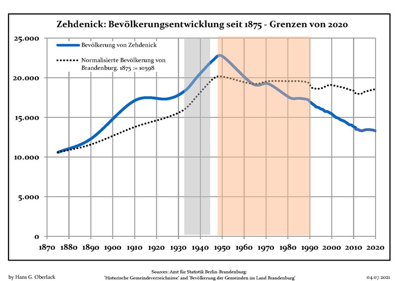
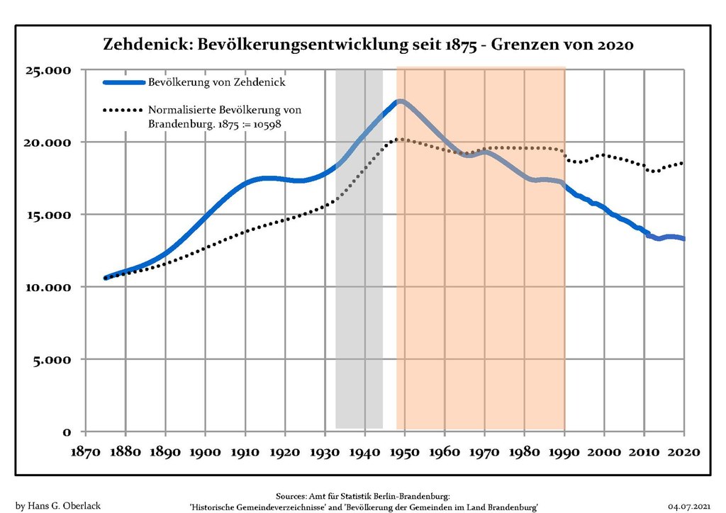
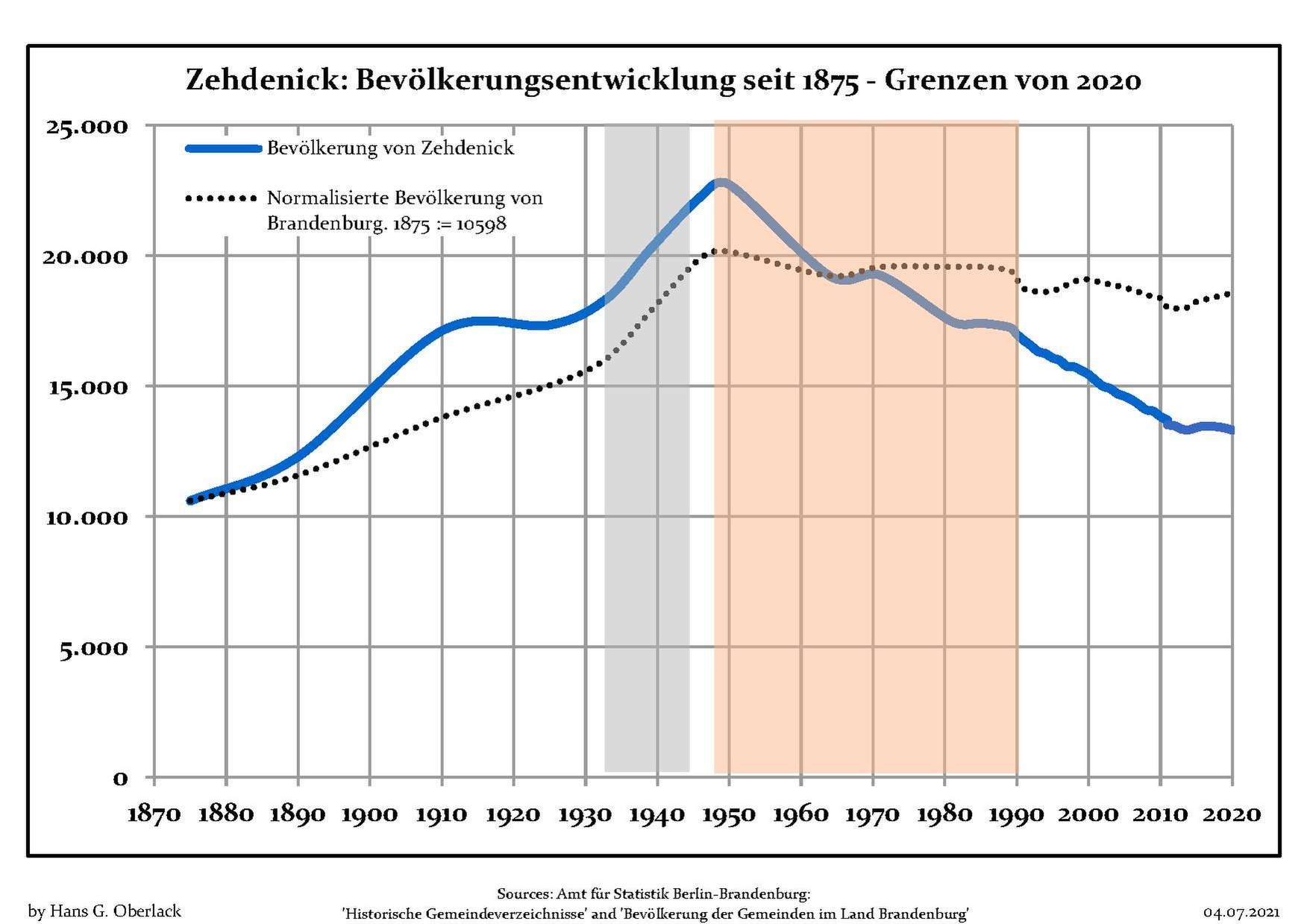
Deutsch: Bevölkerungsentwicklung in den heutigen Grenzen (2020) von Zehdenick, Landkreis Oberhavel, Land Brandenburg, Deutschland
Blaue Linie: Bevölkerung -- Punktierte Linie: Vergleich mit der Entwicklung Brandenburgs Grauer Hintergrund: Zeit der Nazi-Herrschaft -- Roter Hintergrund: DDR-Zeit English: Population development within the current boundaries (2020) of Zehdenick, Oberhavel district, Brandenburg state, Germany
Blue line: Population -- Dotted line: Comparison to population development of Brandenburg state Grey background: Time of nazi rule -- Red background: Time of communist rule Español: Desarrollo de la población en los actuales límites (2020) de Zehdenick, distrito de Oberhavel, estado de Brandenburg, Alemania
Línea azul: Habitantes -- Línea de puntos: Comparación con el desarrollo de Brandenburgo Fondo gris: Período del gobierno nazi -- Fondo Rojo: Época communista Français : Évolution de la population dans les limites actuelles (2020) de Zehdenick, arrondissement de Oberhavel, Land de Brandebourg, Allemagne
Ligne bleue: Population -- Ligne pointillé: Comparaison avec le développement de Brandebourg Fond gris: Période du régime nazie -- Fond rouge: Période du régime communiste Italiano: Sviluppo della popolazione all'interno degli attuali confini (2020) di Zehdenick , circondario di Oberhavel, stato federato del Brandeburgo, Germania
Linea Blu: Popolazione -- Linea puntinata: Confronto dello sviluppo della popolazione dello stato del Brandenburgo Sfondo grigio: Ai tempi del governo nazista -- Sfondo rosso: Al tempo del governo comunista Nederlands: Ontwikkeling van de bevolking binnen de huidige grenzen (2020) van Zehdenick, landkreis Oberhavel, deelstaat Brandenburg, Duitsland
Blauwe lijn: Bevolking -- Stippellijn: Vergelijking van de ontwikkeling van de bevolking van de deelstaat Brandenburg Grijze achtergrond: tijdens de nazi-regering -- Rode achtergrond: tijdens de communistische regering Polski: Rozwój ludności w obecnych granicach (2020) dla Zehdenick, powiat Oberhavel, kraj Brandenburgia, Niemcy
Niebieska linia: Populacja -- Linia przerywana: Porównanie z rozwoju Brandenburgii Szare tło: Okres hitlerowców -- Czerwone tło: Okres rządów komunistycznych Svenska: Befolkningsutvecklingen i de nuvarande gränserna (2020) för Zehdenick, landkreis Oberhavel, delstaten Brandenburg, Tyskland Blå linje: Befolkning -- Prickade linjen: Jämförelse med utvecklingen av Brandenburg Grå bakgrund: Period av Nazi styre -- Röd bakgrund: Period av kommunistiskt styre |
| Date | between 28 December 2011 and 4 July 2021 |
| Source | Own work based on: Data sources displayed at Population Projection Brandenburg at Wikimedia Commons |
| Author | Hans G. Oberlack |
| Latest population data | 2020 |
| Object location | | View this and other nearby images on: OpenStreetMap |
|---|
Licensing
I, the copyright holder of this work, hereby publish it under the following license:
This file is licensed under the Creative Commons Attribution-Share Alike 3.0 Unported license.
- You are free:
- to share – to copy, distribute and transmit the work
- to remix – to adapt the work
- Under the following conditions:
- attribution – You must give appropriate credit, provide a link to the license, and indicate if changes were made. You may do so in any reasonable manner, but not in any way that suggests the licensor endorses you or your use.
- share alike – If you remix, transform, or build upon the material, you must distribute your contributions under the same or compatible license as the original.
File history
Click on a date/time to view the file as it appeared at that time.
| Date/Time | Thumbnail | Dimensions | User | Comment | |
|---|---|---|---|---|---|
| current | 08:48, 4 July 2021 |  | 1,752 × 1,239 (119 KB) | Hans G. Oberlack | 2017, 2018, 2019, 2020 data added |
| 00:43, 14 January 2018 | 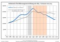 | 1,752 × 1,239 (119 KB) | Hans G. Oberlack | 2016 data added | |
| 22:11, 17 March 2017 |  | 1,752 × 1,239 (117 KB) | Hans G. Oberlack | 2015 data added | |
| 10:30, 5 July 2015 | 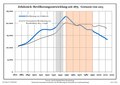 | 1,752 × 1,239 (97 KB) | Hans G. Oberlack | Graphics adjusted to recent data | |
| 19:21, 23 July 2012 | 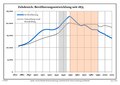 | 1,752 × 1,239 (96 KB) | Hans G. Oberlack | Comparison with development of Brandenburg state added | |
| 14:39, 28 December 2011 | 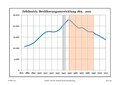 | 1,752 × 1,239 (99 KB) | Hans G. Oberlack |
File usage
The following pages on the English Wikipedia use this file (pages on other projects are not listed):
Global file usage
The following other wikis use this file: