
Size of this PNG preview of this SVG file: 750 × 600 pixels. Other resolutions: 300 × 240 pixels | 600 × 480 pixels | 960 × 768 pixels | 1,280 × 1,024 pixels | 2,560 × 2,048 pixels | 1,000 × 800 pixels.
Original file (SVG file, nominally 1,000 × 800 pixels, file size: 186 KB)
| This is a file from the Wikimedia Commons. Information from its description page there is shown below. Commons is a freely licensed media file repository. You can help. |
W3C-validity not checked.
Summary
| Description |
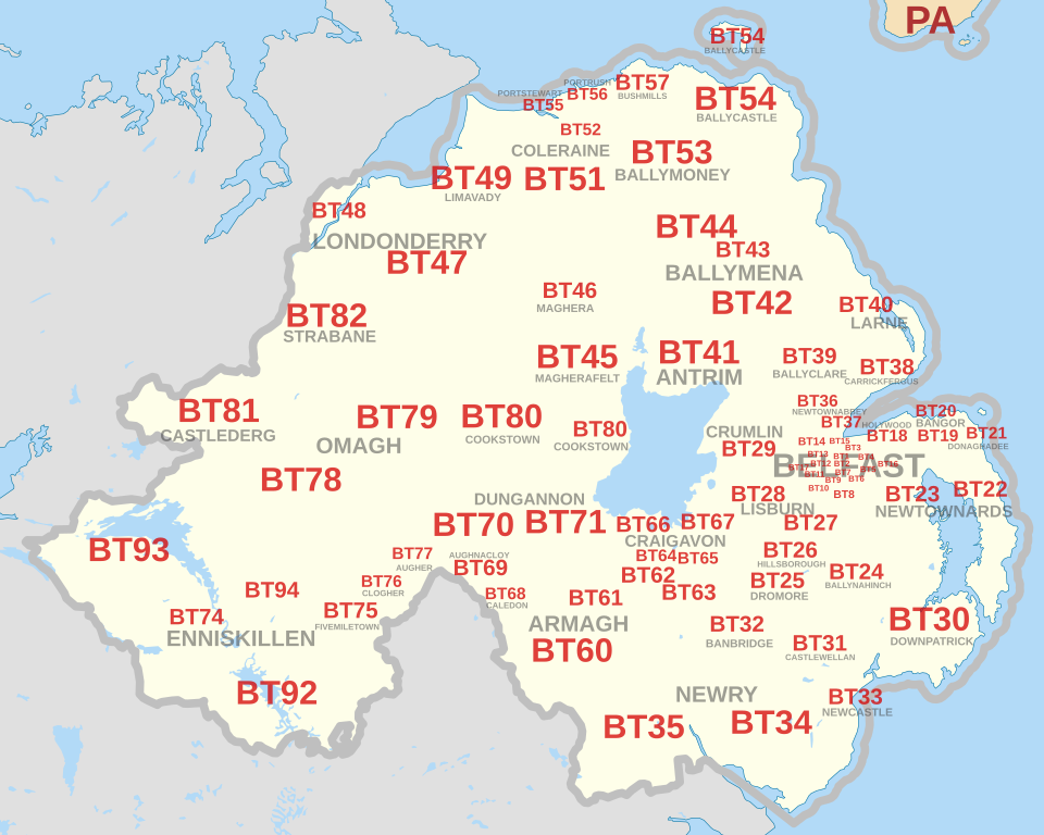
English: Labelled map of Royal Mail postcode districts of the BT postcode area.
Indicative postcode district labels shown in red, post town labels shown in grey. Equirectangular projection with latitude stretching 170%, WGS84 datum. Geographic limits:
|
| Date | |
| Source | National borders and coastline data derived from File:United Kingdom location map.svg. |
| Author | Richardguk |
| Camera location | | View this and other nearby images on: OpenStreetMap |
|---|
See also 
|
Licensing
I, the copyright holder of this work, hereby publish it under the following license:
This file is licensed under the Creative Commons Attribution-Share Alike 3.0 Unported license.
- You are free:
- to share – to copy, distribute and transmit the work
- to remix – to adapt the work
- Under the following conditions:
- attribution – You must give appropriate credit, provide a link to the license, and indicate if changes were made. You may do so in any reasonable manner, but not in any way that suggests the licensor endorses you or your use.
- share alike – If you remix, transform, or build upon the material, you must distribute your contributions under the same or compatible license as the original.
This vector image includes elements that have been taken or adapted from this file:
File history
Click on a date/time to view the file as it appeared at that time.
| Date/Time | Thumbnail | Dimensions | User | Comment | |
|---|---|---|---|---|---|
| current | 11:25, 16 October 2012 | | 1,000 × 800 (186 KB) | Richardguk | revised styling for BT postcode area map - no OpenData boundaries for Northern Ireland |
| 19:18, 10 October 2012 |  | 1,000 × 800 (186 KB) | Richardguk | User created page with UploadWizard |
File usage
The following pages on the English Wikipedia use this file (pages on other projects are not listed):
Global file usage
The following other wikis use this file:
- Usage on fr.wikipedia.org
- Usage on it.wikipedia.org