
Size of this preview: 355 × 600 pixels. Other resolutions: 142 × 240 pixels | 284 × 480 pixels | 454 × 768 pixels | 606 × 1,024 pixels | 1,741 × 2,941 pixels.
Original file (1,741 × 2,941 pixels, file size: 248 KB, MIME type: image/png)
| This is a file from the Wikimedia Commons. Information from its description page there is shown below. Commons is a freely licensed media file repository. You can help. |
Summary
| Description |
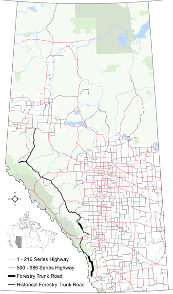
English: The alignments of the remaining and historical segments of Forestry Trunk Road within Alberta in relation to the balance of the provincial highway system within other base features including hydrography, national/provincial parks and the provincial green and white zones. |
| Date | |
| Source | Own work |
| Author | Hwy43 |
Licensing
I, the copyright holder of this work, hereby publish it under the following license:
This file is licensed under the Creative Commons Attribution 4.0 International license.
- You are free:
- to share – to copy, distribute and transmit the work
- to remix – to adapt the work
- Under the following conditions:
- attribution – You must give appropriate credit, provide a link to the license, and indicate if changes were made. You may do so in any reasonable manner, but not in any way that suggests the licensor endorses you or your use.
File history
Click on a date/time to view the file as it appeared at that time.
| Date/Time | Thumbnail | Dimensions | User | Comment | |
|---|---|---|---|---|---|
| current | 07:31, 2 January 2018 | | 1,741 × 2,941 (248 KB) | Hwy43 | Added spur of Forestry Trunk Road between Muskeg River and Grande Cache ranger head quarters that existed through the mid/late 1960s according to the Atlas of Alberta, 1968 |
| 05:12, 2 January 2018 |  | 1,741 × 2,941 (248 KB) | Hwy43 | minor symbology changes | |
| 04:55, 2 January 2018 |  | 1,741 × 2,941 (248 KB) | Hwy43 | User created page with UploadWizard |
File usage
The following pages on the English Wikipedia use this file (pages on other projects are not listed):