File:ANSELMO HEADFRAME AND TIPPLE LOOKING EAST - Butte Mineyards, Anselmo Mine, Butte, Silver Bow County, MT HAER MONT,47-BUT.V,1-A-32.tif

Size of this JPG preview of this TIF file: 755 × 600 pixels. Other resolutions: 302 × 240 pixels | 604 × 480 pixels | 967 × 768 pixels | 1,280 × 1,017 pixels | 2,560 × 2,034 pixels | 5,000 × 3,972 pixels.
Original file (5,000 × 3,972 pixels, file size: 18.94 MB, MIME type: image/tiff)
| This is a file from the Wikimedia Commons. Information from its description page there is shown below. Commons is a freely licensed media file repository. You can help. |
Summary
| ANSELMO HEADFRAME AND TIPPLE LOOKING EAST - Butte Mineyards, Anselmo Mine, Butte, Silver Bow County, MT | ||||
|---|---|---|---|---|
| Photographer |
Related names:
|
|||
| Title |
ANSELMO HEADFRAME AND TIPPLE LOOKING EAST - Butte Mineyards, Anselmo Mine, Butte, Silver Bow County, MT |
|||
| Depicted place | Montana; Silver Bow County; Butte | |||
| Date | Documentation compiled after 1968 | |||
| Dimensions | 4 x 5 in. | |||
| Current location |
Library of Congress Prints and Photographs Division Washington, D.C. 20540 USA http://hdl.loc.gov/loc.pnp/pp.print |
|||
| Accession number |
HAER MONT,47-BUT.V,1-A-32 |
|||
| Credit line |
|
|||
| Notes |
|
|||
| Source | https://www.loc.gov/pictures/item/mt0095.photos.101163p | |||
| Permission (Reusing this file) |
|
|||

| Object location | | View this and other nearby images on: OpenStreetMap |
|---|
File history
Click on a date/time to view the file as it appeared at that time.
| Date/Time | Thumbnail | Dimensions | User | Comment | |
|---|---|---|---|---|---|
| current | 18:30, 28 July 2014 | 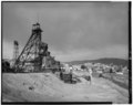 | 5,000 × 3,972 (18.94 MB) | Fæ | GWToolset: Creating mediafile for Fæ. HABS 24 July 2014 (2001:2300) |
File usage
The following pages on the English Wikipedia use this file (pages on other projects are not listed):
Global file usage
The following other wikis use this file:
- Usage on es.wikipedia.org
- Usage on fy.wikipedia.org
- Usage on id.wikipedia.org