File:3-4 VIEW, LOOKING NORTHWEST. - Philadelphia and Reading Railroad, Reading Depot, North Sixth Street at Woodward Street, Reading, Berks County, PA HAER PA,6-READ,9-5.tif

Size of this JPG preview of this TIF file: 752 × 599 pixels. Other resolutions: 301 × 240 pixels | 602 × 480 pixels | 963 × 768 pixels | 1,280 × 1,020 pixels | 2,560 × 2,041 pixels | 5,000 × 3,986 pixels.
Original file (5,000 × 3,986 pixels, file size: 19.01 MB, MIME type: image/tiff)
| This is a file from the Wikimedia Commons. Information from its description page there is shown below. Commons is a freely licensed media file repository. You can help. |
Summary
| 3-4 VIEW, LOOKING NORTHWEST. - Philadelphia and Reading Railroad, Reading Depot, North Sixth Street at Woodward Street, Reading, Berks County, PA | ||||
|---|---|---|---|---|
| Photographer |
Barrett, William Edmund |
|||
| Title |
3-4 VIEW, LOOKING NORTHWEST. - Philadelphia and Reading Railroad, Reading Depot, North Sixth Street at Woodward Street, Reading, Berks County, PA |
|||
| Description |
Lorenz, William; Barrett, William E, photographer |
|||
| Depicted place | Pennsylvania; Berks County; Reading | |||
| Date | 1975 | |||
| Dimensions | 4 x 5 in. | |||
| Current location |
Library of Congress Prints and Photographs Division Washington, D.C. 20540 USA http://hdl.loc.gov/loc.pnp/pp.print |
|||
| Accession number |
HAER PA,6-READ,9-5 |
|||
| Credit line |
|
|||
| Notes |
|
|||
| Source | https://www.loc.gov/pictures/item/pa1783.photos.355807p | |||
| Permission (Reusing this file) |
|
|||

| Object location | | View this and other nearby images on: OpenStreetMap |
|---|
File history
Click on a date/time to view the file as it appeared at that time.
| Date/Time | Thumbnail | Dimensions | User | Comment | |
|---|---|---|---|---|---|
| current | 01:00, 31 July 2014 | 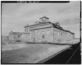 | 5,000 × 3,986 (19.01 MB) | Fæ | GWToolset: Creating mediafile for Fæ. HABS 30 July 2014 (2901:3000) |
File usage
The following pages on the English Wikipedia use this file (pages on other projects are not listed):