This article needs additional citations for verification. (March 2015) |
Earthworks are engineering works created through the processing of parts of the earth's surface involving quantities of soil or unformed rock.

Shoring structures edit
An incomplete list of possible temporary or permanent geotechnical shoring structures that may be designed and utilised as part of earthworks:
Gallery edit
-
-

-
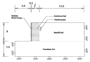
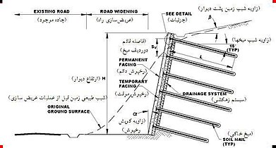
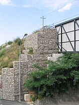
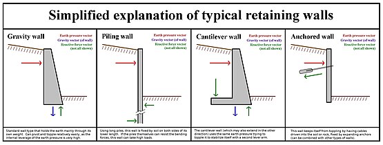 Retaining wall types
 -
-

-

-

-

-
-


Excavation edit
_(14569641579).jpg)
Excavation may be classified by type of material:[1]: 13.1
- Topsoil excavation
- Earth excavation
- Rock excavation
- Muck excavation – this usually contains excess water and unsuitable soil
- Unclassified excavation – this is any combination of material types
Excavation may be classified by the purpose:[1]: 13.1, 13.2
Civil engineering use edit
Typical earthworks include road construction, railway beds, causeways, dams, levees, canals, and berms. Other common earthworks are land grading to reconfigure the topography of a site, or to stabilize slopes.

Military use edit

In military engineering, earthworks are, more specifically, types of fortifications constructed from soil. Although soil is not very strong, it is cheap enough that huge quantities can be used, generating formidable structures. Examples of older earthwork fortifications include moats, sod walls, motte-and-bailey castles, and hill forts. Modern examples include trenches and berms.
Equipment edit
Heavy construction equipment is usually used due to the amounts of material to be moved — up to millions of cubic metres. Earthwork construction was revolutionized by the development of the (Fresno) scraper and other earth-moving machines such as the loader, the dump truck, the grader, the bulldozer, the backhoe, and the dragline excavator.
Mass haul planning edit

Engineers need to concern themselves with issues of geotechnical engineering (such as soil density and strength) and with quantity estimation to ensure that soil volumes in the cuts match those of the fills, while minimizing the distance of movement. In the past, these calculations were done by hand using a slide rule and with methods such as Simpson's rule. Earthworks cost is a function of hauled amount x hauled distance. The goal of mass haul planning is to determine these amounts and the goal of mass haul optimization is to minimize either or both.[2]
Now they can be performed with a computer and specialized software, including optimisation on haul cost and not haul distance (as haul cost is not proportional to haul distance).
See also edit
- Contour trenching – Conservation technique in agriculture
- Cut and fill – Earthmoving technique to minimize labor
- Earth movers – Vehicles designed for executing construction tasks, construction/engineering vehicles used for earthworks civil engineering
- Earth structure – Building or other structure made largely from soil
- Gabion – Cage full of rock
- Keyline design – Landscaping to optimize water usage
- Land restoration – Reinstatement of damaged landscape
- Grading (earthworks) – In civil engineering, creating a profile
- Spoil tip – Pile built of accumulated spoil
- Subgrade – Material underneath a road or track
- Terrace (earthworks) – Terrain formed by tiered platforms
Calculation software edit

Earthwork software is generally a subset of CAD software, in which case it often an add-on to a more general CAD package such as AutoCAD.[3] In that case, earthwork software is principally used to calculate cut and fill volumes which are then used for producing material and time estimates. Most products offer additional functionality such as the ability to takeoff terrain elevation from plans (using contour lines and spot heights); produce shaded cut and fill maps; produce cross sections and visualize terrain in 3D.[4] The means by which volumes are calculated in software can differ quite considerably leading to potentially different results with the same input data. Many software products use methods based on triangulated irregular networks (TINS) and triangular prism volume algorithms, however other calculation methods are in use based on rationalizing elevations into high density grids or cross-sections.[5][6][7]
A few programs are specialised in earthworks transport optimization and planning the construction works.
References edit
- ^ a b Frederick S. Merritt, M. Kent Loftin, Jonathan T. Ricketts, Standard Handbook for Civil Engineers, Fourth Edition, McGraw-Hill Book Company, 1995.
- ^ "Earthworks cost optimization through mass haul planning". www.topconplanning.com. Archived from the original on 2 April 2015. Retrieved 7 June 2015.
- ^ "Taking the Measure of Methods for Estimating Earthwork Volumes - Forester Network". Forester Network. Retrieved 2016-02-09.
- ^ "Vertigraph, Inc. -- Automating the Takeoff & Estimating Process". www.vertigraph.com. Archived from the original on 2015-12-15. Retrieved 2016-02-09.
- ^ "How to Estimate Cut and Fill Volumes for Earthworks Projects | Grid Method, Cross Section Method, Earthworks Software". www.kublasoftware.com. Retrieved 2016-02-09.
- ^ "Vertigraph, Inc. -- Calculating Cut and Fill Quantities : Modern Techniques and Best Practices". vertigraph.com. Archived from the original on 2016-01-31. Retrieved 2016-02-10.
- ^ Cheng, Jian-chuan; Jiang, Long-jian (2013-11-06). "Accuracy Comparison of Roadway Earthwork Computation between 3D and 2D Methods". Procedia - Social and Behavioral Sciences. Intelligent and Integrated Sustainable Multimodal Transportation Systems Proceedings from the 13th COTA International Conference of Transportation Professionals (CICTP2013). 96: 1277–1285. doi:10.1016/j.sbspro.2013.08.145.
External links edit
 Media related to Earthworks at Wikimedia Commons
- Saving Old Dirt: The Preservation of Earthworks at the American Battlefield Trust