- This draft is to develop about the NRHP historic district and the smaller National Historic Landmark District named Civic Center Historic District, with expectation this will be summarized in a section of the Denver Civic Center. Or split into an article about Civic Center Park and the rest merged to a section in Denver Civic Center? Anyone is welcome to contribute here.
Civic Center Historic District | |
| Location | Roughly bounded by W. Colfax, E. Colfax, Grant, E. 14th, Broadway, E. 13th, W. 13th, Bannock, W. 14th, and Delaware, Denver, Colorado |
|---|---|
| Area | 82 acres (33 ha) |
| Architect | Multiple |
| Architectural style | City Beautiful, Beaux-Arts, Late 19th and 20th Century Revivals, Greek Revival, Late Victorian |
| NRHP reference No. | 74002348[1] |
| Significant dates | |
| Added to NRHP | February 27, 1974 |
| Designated NHLD | March 16, 2012[2] |
The Civic Center Historic District is an 82-acre (33 ha) area in Denver, Colorado, roughly bounded by W. Colfax, E. Colfax, Grant, E. 14th, Broadway, E. 13th, W. 13th, Bannock, W. 14th, and Delaware, which was listed on the National Register of Historic Places in 1974.
A civic center, in modern usage, can include buildings and various civic centers do, but per the NRHP listing document, Denver's Civic Center "is an open plaza designed to link together various public buildings. It also provides a gateway to downtown Denver and is situated between downtown Denver and the Capitol Hill residential area".
Overview: "Built around the perimeter of the Civic Center and the State Capitol grounds are buildings which house state and city governmental offices and state and city public facilities. The two dominant buildings in the Civic Center District are the State Capitol Building at the east edge of the District and the City and County Building at the west edge of Civic Center. Behind the City and County Building is the United States Mint at the west boundary of the District."[3]
The National Register of Historic Places' historic district named Civic Center Historic District(???) or Denver City Center Historic District is not a huge area. It includes City Center Park and the Colorado State Capitol building.[5]
Architecture: Late 19th and 20th Century Revivals, Greek Revival, Late Victorian Other names: See Also:Civic Center Historic Historic function: Government; Landscape; Recreation And Culture Historic subfunction: Work Of Art (sculpture, Carving, Rock Art); Museum; Capitol; Park; Government Office Criteria: event, architecture/engineering
Its 82-acre (33 ha) area includes 12 contributing buildings, two contributing structures, and nine contributing objects.[1]
Around 1911?, under Denver mayor Henry J. Arnold, the area was cleared, except for the 1910-built public library, to make way for a City Center.
The prospective area studied by nationally-recognized city planners Frederick Law Olmstead and Alfred Brunner [who recommended what? who came out with a __page report?]. Robert W. Speer became mayor (for the third time) in 1916, and commissioned E. H. Bennett, Chicago's City Planner, to develop a plan. It was Bennett's plan which has governed since.(mostly ??)
In 2022, its Civic Center Park portion, is managed(?) or financially supported(?) by The Cultural Landscape Foundation [ try Cultural Landscape Foundation [6]
The 12 contributing buildings, and ___ non-contributing ones, that were in place in 1973 are:
- Colorado State Capitol (1908), at east end of plaza
- City and County Building (1932), facing Capitol, at west end of plaza, 1437 Bannock Street. Greek Revival in style, it was kept low in height to preserve Capitol's view of mountains.
- Denver Mint, behind the City and County Building
- Colorado State Museum (1919), south of Capitol across E. 14th Ave. Museum and library. In 1973 this was headquarters for Colorado Historical Society, which later became History Colorado?.
- State Archives Building (1889), aka Woodward House, 1530 Sherman St. (where in relation to others?). Eclectic Victorian in style, built of rusticated red sandstone. (check source in Draft:Peabody-Whitehead Mansion article, if the stone is from whatever canyon???) " originally a single feimily residence, is one of the few remaining examples of late Victorian architecture which was at one time so prevalent in the Capitol Hill area" which is where many wealthy and most prominent citizens lived.[3]

- McNichols Civic Center Building (1910), 144 West Coifax Avenue at Bannock Street (what relation to others???). In 1973 this was the Board of Water Commissioners Building, aka Water Board Building. Previously it served the main Denver Public Library building until 1956. It was built as a Carnegie library in 1910.
- Denver Art Museum (1971), 100 West 14th Avenue Parkway. (Non-contributing) Per NRHP document "it's modern design is visually pleasing in contrast with the classic styles of the structures in Civic Center and the City and County building".[3]
- the Byers-Evans House (1880), at 1310 Bannock St., historic ____, now a house museum covering Colorado women's history, on southwest corner of block including Denver Art Museum
- University of Denver Law Center (1960), 200 West 14th Avenue. (Non-contributing) Modern style.
- Denver Public Library (1956), (Non-contributing) (main library), 1357 Broadway. " Modern. The scale, massing and color reflect the Classical design of the Civic center." "The building along with lawns and parking lie between West 14th Avenue and West 13th Avenue which is the south boundry of the Civic Center District."
- State Capitol Annex (1939), corner of Sherman Street & East 14th Ave.
- State Office Building (Denver, Colorado) (1919-1921), aka Tate Office Building, at corner East Colfax Avenue and Sherman Street
- State Services Building (1960), across E. Colfax Ave. from Capitol (which direction?) and across Sherman St. from the State Office Building.
- First Baptist Church (Denver, Colorado), at corner East 14th Avenue and Grant Street (across East 14th Avenue to the south of the Capitol and next door to the east of the State Museum Building.
- Hospitality Center (1951), 225 West Colfax Avenue. Small low building "on a small island made by the convergence of Court Place and 14th Street with West Colfax Avenue directly north of the City and County Building". In 1973 was headquarters for the Denver Convention and Visitor's Bureau. "Near the north entrance is a hitching post owned by David H. Moffat, prominent Denver citizen during the mining era and builder of the Moffet Railroad Tunnel under the Continental Divide." (is this one of the contributing objects???)
- Denver Mint (1904), West Colfax Avenue and Cherokee Street, behind the City and County Building, at west end of the Civic Center Historic District. Its "building style was copied from the old Medici Bank of Florence, Italy" (meaning it is not a copy of that building, right? link to Florence building)
The buildings are coordinated(?) architecturally. Most of their occupants have "functional importance to the Civic Center District" meaning they have functions related to others in the district so co-locating is helpful.
Several are built of Colorado materials, with small exceptions, including:
- State Office Building (Denver, Colorado), whose exterior is dressed Colorado cotopaxi granite (try cotopaxi?) and Colorado Yule marble.
- Byers-Evans House (does it qualify?) its exterior is red sandstone from whatever canyon
- Board of Water Commissioners Building (does it qualify? built of Turkey Creek sandstone (try Turkey Creek)
Tunnels connect the Colorado State Museum to the Capitol to the State Office Building. These were closed to pedestrians as of 1973,[3] and in 2022 they [remain closed?].
Several buildings are individually listed on the National Register, two before the historic district listed:
- the Denver Mint, where ___ since ___, which in 2022 is operating ___ and sometimes open for tours(???), individually NRHP-listed 19__
- Byers-Evans House (1880, individually NRHP-listed 1970)
- First Baptist Church of Denver (___, individually NRHP-listed 2005)
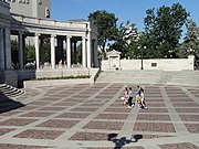
Civic Center Park edit
The Civic Center itself, or Civic Center Park...
Two contributing structures are:
- Greek Theater and Colonnade of Civic Benefactors (1919), south side of Civic Center. This is an open air theater, Greek Revival in style, with ___how many?___ Ionic columns. Its interior walls are Tennessee marble. It was designed by architects Marean and Norton and E.H. Bennett. It has two lunettes by Allen True (per photo caption for 14th of NPS photos page 28 of PDF). [Set up redirect for Colonnade of Civic Benefactors ??]
- "Materials – Interior walls are of Tennessee marble."
- "Structure plan – Rectangular central portion with curved colonnade on each side."
- "Use – Public religious services, concerts, square dancing and other public functions."
-
 Greek Theater and wall listing civic benefactors. Semi-circular tiered seating continues to right.
 -
 Civic Benefactors plaque.
 -
 Wall listing donors.


- Voorhies Memorial Gateway (1921), north side of Civic Center. Designed by Denver architects Fisher and Fisher, its archway provides an entrance to downtown Denver. Has curved colonnade with __how many?__ . Has "pool with two sea lion fountains". [ Are there two or just one? Sea lion fountain by Robert Garrison. "High up on the interior walls of the central portion are two lunettes by Allen True, Denver artist who painted the murals in the rotunda of the State Capitol Building. The lunettes, painted in ancient Greek style, are of groups of native Colorado animals. They are painted directly on the concrete." As of 1973, they were "badly faded from exposure to the weather."
"The Greek Theater, a companion structure, gives balance and support. John H. P. Voorhies bequested to the City of Denver $125,000 for a memorial to him and his wife to be erected on the Bates Triangle. Bates Triangle was a parcel of land at the corner of Colfax and Broadway which was separated from the main body of Civic Center by Colfax Avenue. Mr. Voorhies, a pioneer Denver resident had lived for many years opposite the Bates Triangle. He came to Silverton, Colorado, in the early 1870s from Lexington, Kentucky. He settled in Denver in 1885 and became prominent politically and socially, investing in mining property and other large realty holdings. The Memorial was completed by the end of 1921 and the pool and fountains in the spring of 1922. With the construction of the Voorhies Memorial, Colfax Avenue was closed at this point and moved to the north." "On the walk south of the Voorhies Memorial, about 20 yards from the intersection of Colfax and Broadway, there is a bronze plaque set in a large stone base. A street light is mounted on the base. This plaque commemorates the end of the streetcar era which lasted nearly 80 years starting in 1871. This is near the site of the cable house which provided power for the transit lines. The plaque was presented to the City of Denver by the Colorado State Historical Society and The American Pioneer Trails Association on June 3, 1950, the day the streetcars were placed by rubber-tired vehicles." [Is there now a proper noun name for the plaque/memorial? Yikes, the APTA was part of roads and cars promotion?, funded by whom? ]
In 1973, it included nine contributing objects and __ non-contributing ones [in what order, by creation date or going clockwise or what?]:
- "Pioneer Monument" (1911), (photo 16 and caption, pages 33-34 in NPS photos PDF)" (A fountain) Intersection of Broadway, Cheyenne Place and west Colfax Avenue
Sculptor – Frederick MacMonnies
Materials – Base is Colorado granite. Figures are bronze.
"At the top of the monument, facing to the east, is Kit Carson pointing the way westward. He is sitting astride a horse wearing buckskin clothes and holding a rifle. Below the top is a bronze frieze in the form of skulls and horns of oxen. On the three faces below the frieze, are three dedication and
commemorative plaques. One plaque states that here was the end of the famous Smoky Hill Trail. [what is that, is it famous????] On the sill of the hexagonal base are three larger than life bronze figures representing the prospector, the Hunter and the Pioneer Mother and Child. There are five steps leading up to the base. At the top of the steps were bronze standards holding [which held?] electric lamps which have been removed. The Pioneer Monument was erected under the auspices of the Denver Real Estate Exchange. The Exchange was also responsible for establishing our system of Mountain parks. Frederick MacMonnies, a well known sculptor, was given the contract to design the pioneer Monument on May 16, 1907. The funds for the monument were from donations from the State of Colorado, the City of Denver, the Denver Real Estate Exchange, Walter S. Cheesman, Thomas F. Walsh [? the architect Thomas F. Walsh of Gove & Walsh or multimillionaire Colorado miner Thomas Walsh (miner)? ] and the rest was raised by popular subscription from prominent Denver citizens."

- "Christopher Columbus (statue)" (1970) – "Civic Center Park. Noncontributing object" Christopher Columbus, as envisioned by sculptor William Johnson


- "On the War Trail", on the plaza "A bronze statue of an Indian on a horse by Alex Phimister Proctor. "Big Beaver" or Jackson Sundown was the Indian model and a horse named "Satan". The cost was $15,000 and was presented to the City of Denver by Stephen Knight in 1922."
- [[Bronco Buster (Denver, Colorado)|Bronco Buster, "A bronze statue of a rider on a bucking horse by Alex Phimister Proctor, presented to the City of Denver by John Kernan Mullen and Stephen Knight in 1920.

.jpg)
- Two Civil War cannons (1862-63) "West Capitol grounds. Two contributing objects"
- Colorado Volunteers Flag Pole (n.d.) [try Colorado Volunteers "Lower capitol grounds – Lincoln Park. Contributing object
- Liberty Bell (1950) – "Lower capitol lawn-Lincoln Park. Noncontributing object"

- Ten Commandments Plaque (1956) – "Lower capitol lawn-Lincoln Park. Noncontributing
object" [is it correct to call this, standing alone, a plaque?]

- Sadie M. Likens Water Fountain (1923) – "Lower capitol lawn-Lincoln Park at corner
of East Colfax Avenue and Broadway. Contributing object." Diminutive Sadie Likens (c.1840-1920) was Denver's first prison matron, and prominent in other charitable work including of Women's Christian Temperance Union and Denver Orphan's Home. Was she technically Denver's first female police officer(?).[7]
Post-1973 objects: {{Gallery |Kenneth MacKenzie MacIntosh memorial - Civic Center Park, Denver - DSC01184.jpg|Kenneth MacKenzie MacIntosh memorial (try Kenneth MacIntosh, MacIntosh (surname)). |United Nations Square - Civic Center Park, Denver - DSC01212.jpg|United Nations Square |EmilyGriffithMemorial.jpg|Emily Griffith memorial
National Historic Landmark edit
A portion of the NRHP-listed historic district was further designated as a National Historic Landmark District in 2012, providing recognition that this area is extraordinary.
The NHL district's boundaries were defined to include only the buildings, objects, and area "that reflect the City Beautiful origins of the civic center, historic plans dating from 1885 to 1932, and unifying influence of Beaux Arts design."[8]
Denver Landmark edit
In 19__, the Denver city council designated "Civic Center Landmark District" to be a Denver Landmark.[9]
The designation means that [any changes require approval by Denver's historic preservation committee?].
The area covered is [the same as, smaller, larger, how?] the NRHP district.
The city council has designated three individual Denver Landmarks which are noted to be within this Landmark District. These are:
- Evans House, commonly known as Byers Evans House,
- First Baptist Church, and
- Denver U.S. Mint.[10]
Notes on documentation edit
Civic Center Park edit
Civic Center Park is at the center of the districts, including open space with lawns and plazas and objects and the two structures? Is it exactly defined in any source?
- Per Denver.org (what is that, official City of Denver or not?)[11]
- Per NRHP docs?
- Per NHL docs?
NRHP HD edit
The district is named "Civic Center Historic District" (in all docs of the NRHP district?) or "Denver City Center Historic District" at History Colorado page about both NRHP and NHL, or "Civic Center National Register Historic District" by History Colorado, in identical preface pages of https://www.historycolorado.org/sites/default/files/media/document/2017/5DV161_0.pdf and https://www.historycolorado.org/sites/default/files/media/documents/2017/5dv11336_nhl.pdf which both say: "The Denver Civic Center National Historic Landmark District does not include all of the original recorded features and buildings listed within the Civic Center National Register Historic District (5DV.161) and has a different boundary. Therefore, OAHP has assigned a new site number for the National Historic Landmark District (5DV.11336)."
There is no difference between Colorado state-defined and Federal-defined historic district. There are three different versions of NRHP documentation:
- Version at NPS: [this PDF-1 with text], a 52 page PDF for the text and [this PDF-2 with photos and captions], a 136 page PDF for 68 photos and captions (17 photos [all??? from 1972-73] with typed long caption pages, and 51 photos [all??? from ???] with handwritten short captions).[3]
- Version at NARA, a 202-page PDF.[12]
- Version at History Colorado, an 82-page PDF, which includes __-page copy/version of the original 1974-approved NRHP document. This described many but not all of the buildings and objects included in the NRHP area. Gave bounds of rectangle enclosing the historic district but did not define the district by a map. What does this version NOT include (perhaps photos, correspondence in others?
- It also includes __page 1978 amendment document, with refnum _______, that more clearly defined the historic district by sketch maps with boundaries. Provided description of other buildings and objects in the district, and updates from demolition(?) and construction between 1973 and 1978. Establishes numbering for all(?) objects in the district and for all(?) buildings, and clarified contributing vs. non-contributing status.
Question: Does either NPS or NARA have the 1978 amendment?
NHL district edit
The National Historic Landmark District named "Denver Civic Center" (??? confirm this name is in all versions of NHL doc) (or "Denver Civic Center Historic District" (by History Colorado at its page on both) or "Denver Civic Center National Historic Landmark District" (in its preface pages) is a smaller area. Three versions (possibly all the same? or describe differences?) of NHL documentation defining and describing National Historic Landmark District.
- Version at Wayback archive, 161-page PDF originally from NPS at Original NPS URL with nothing now. This is not signed. This was labelled "'Draft NHL nomination for Denver Civic Center' (PDF). National Park Service. Retrieved 2020-04-13", at Denver Civic Center article, but the URL includes "spring2012".[8]NHL declared March 16, 2012, wayback's crawls were:
- wayback's crawl 1 2012-04-15: https://web.archive.org/web/20120415124952/http://www.nps.gov/nhl/Spring2012Nominations/DenverCivicCenter.pdf, 161 pages
- wayback's crawl 2 2013-11-21: https://web.archive.org/web/20131021172042/http://www.nps.gov/nhl/Spring2012Nominations/DenverCivicCenter.pdf, 161 pages
- wayback's crawl 3 2019-09-27: nothing found at NPS, "302 error"
- wayback's crawl 4 2019-09-27: nothing found at NPS, "302 error"
- Version that can be downloaded from History Colorado: Version from History Colorado page, is a 162 page PDF. Page 1 is preface note dated 2013. This is labelled "FINAL FOR PRINTING" in its Microsoft Word document name, but is not signed.
- Version requested from NPS or NARA, not yet received as of 10/25/2022. Presumably they will have a signed version?
Comment: Currently the NHL doc appears not available online from any Federal website.
Question: This/these include sketch map of 1974/1978 NRHP district which are the same or not?
References edit
- ^ a b "National Register Information System". National Register of Historic Places. National Park Service. November 2, 2013.
- ^ per NHL form, better to cite weekly???
- ^ a b c d e Barbara Norgren; Cynthia Emrick (December 10, 1973). "National Register of Historic Places Inventory/Nomination: Civic Center Historic District". National Park Service. Retrieved October 22, 2022. With accompanying 51 photos from __
- ^ Barbara Norgren; Cynthia Emrick (December 10, 1973). "National Register of Historic Places Inventory/Nomination: Civic Center Historic District". National Park Service. Retrieved October 22, 2022. Includes seven sketch maps. With accompanying 68 photos, mostly from 1988, including aerial photo (#1, page 1 of PDF); See also text and photos available in one PDF, with additional maps and correspondence, from NARA (Downloading may be slow.).
- ^ "Denver Civic Center Historic District". History Colorado. History Colorado. Retrieved 28 March 2020.
- ^ "The Cultural Landscape Foundation: Civic Center Park - Denver". The Cultural Landscape Foundation. Retrieved October 22, 2022.
- ^ "Sadie Likens" (PDF). History Colorado.
- ^ a b R. Laurie Simmons; Thomas H. Simmons (March 31, 2011). "National Historic Landmark Nomination: Civic Center Historic District" (PDF). Wayback machine.
- ^ Denver's list of historic districts or landmark districts
- ^ Denver's list of individual landmarks
- ^ "Civic Center Park". City of Denver.
- ^ Barbara Norgren; Cynthia Emrick (December 10, 1973). National Register of Historic Places Inventory/Nomination: Civic Center Historic District. NARA. Retrieved October 22, 2022. Includes __ photos. (Downloading may be slow.)
Category:Denver, Colorado Category:Civic centers Category:National Register of Historic Places in Denver Category:Historic districts on the National Register of Historic Places in Colorado Category:National Historic Landmark Districts
This article about a property in Colorado on the National Register of Historic Places is a stub. You can help Wikipedia by expanding it. |