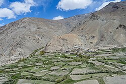
Chah (also Cha) is a small village in the Lungnak valley in Zanskar tehsil, Kargil district, Ladakh, India. The village is situated at the base of a mountain range on the right bank of the Tsarap River. It is located on the Padum-Darcha road, 47 km (29 mi) south from Padum.
Chah
Cha | |
|---|---|
village | |
 Chah village, June 2024 | |
| Coordinates: 33°14′38.25″N 77°07′33.92″E / 33.2439583°N 77.1260889°E | |
| Country | |
| State | Ladakh |
| Area | |
| • Total | 0.838 km2 (0.324 sq mi) |
| Elevation | 3,920 m (12,860 ft) |
| Population (2011) | |
| • Total | 465 |
| • Density | 550/km2 (1,400/sq mi) |
| Languages | |
| Time zone | UTC+5:30 (IST) |
| Postal Index Number | 194302 |
| Website | https://kargil.nic.in/ |
Description
editChah (elevation 3,920 m (12,860 ft)) is a small village in the Lungnak valley on the right bank of the Tsarap River. It is located at a distance of 47 km (29 mi) from Padum on the Padum-Darcha road.[1] The distance from Darcha in Lahaul is 82 km (51 mi), the road climbing over the 5,091 m (16,703 ft) Shinko La pass. Chah village has an area of 83.80 hectares (207.1 acres).[2]: 80
Demographics
editThe population as of the 2011 Census was 465 with 61 households. Females comprised 40.2% of the population. The literacy rate was 56%. All but 2 of the 465 persons belonged to scheduled tribes.[2]: 80-81
Governance
editThe Cha Gram Panchayat is a government office and local self-government body. The villages of Chah and Shunshday (Shan Shaday) come under its jurisdiction.[3] In 2011, the population of these two villages was 709.[2]: 80
Amenities
editChah has a pre-primary and primary school. Household power supply and mobile phone coverage are available. The village has a primary health sub-centre (PHS).[4]: 147–149, 151 There is an India Post branch post office with PIN code 194302.[5]
Economy
editThe economy is largely agrarian with tourism also providing jobs and income. As the annual precipitation is low, fields are irrigated through channels from streams fed by snow-melt.[6] About 46% of the agricultural land is irrigated.[4]: 152
Tourism
editFrom Chah there is a 6 km (3.7 mi) trail to Phugtal Monastery.[7] The trail is difficult in some places. The distance can be covered in 2-3 hours.[8]
Transport
editIn June 2024, the Himachal Road Transport Corporation (HRTC) announced that it would soon commence a bus service from Keylong in Lahaul to Padum. This would run on the Nimmu-Padum-Darcha road and would serve Chah.[9] Taxis are available.[4]: 149
See also
editReferences
edit- ^ "Padum - Cha route". OpenStreetMap. 24 July 2024. Retrieved 24 July 2024.
- ^ a b c District Census Handbook: Kargil, Jammu & Kashmir -- Village and Town Wise Primary Census Abstract (PCA). 3 Part XII B. Directorate of Census Operations, Himachal Pradesh, Ministry of Home Affairs, Govt of India. 2011.
- ^ "Local Government Directory: LGD - Panchayat - Kargil - Jul24.xls". Ministry of Panchayati Raj. Retrieved 30 August 2024.
- ^ a b c District Census Handbook: Kargil, Jammu & Kashmir -- Village and Town Directory. 2 Part XII A. Directorate of Census Operations, Himachal Pradesh, Ministry of Home Affairs, Govt of India. 2011.
- ^ "Find pincode: Ladakh - Kargil". India Post, Dept. of Posts, Ministry of Communications, Govt of India. Retrieved 24 July 2024.
- ^ "Kargil - Ladakh: The climate and soil condition of the district". LAHDCK – Ladakh Autonomous Hill Development Council, Kargil. 13 July 2024. Retrieved 24 July 2024.
- ^ "Chah - Phuktal route". OpenStreetMap. 24 July 2024. Retrieved 24 July 2024.
- ^ Khan, V. (6 August 2023). "Phugtal Monastery – A Complete Travel Guide: Day 2 – Cha to Phugtal Monastery to Purne". Vargis Khan. Retrieved 24 July 2024.
- ^ Tribune News Service (22 June 2024). "Keylong-Padum trial run a success, service on anvil". The Tribune (India). Retrieved 21 July 2024.
