The Calle de Atocha is a street in Madrid, Spain. It constitutes a major axis within the Centro District.
 | |
| Type | street |
|---|---|
| Length | 1.3 km (0.81 mi) |
| Location | Madrid, Spain |
| Northwest end | Plaza de Santa Cruz |
| Southeast end | Plaza del Emperador Carlos V |
History and description edit
It roughly defines an axis cutting through the old city town from northwest to southeast,[1] straddling along the border between the current Embajadores and Cortes neighborhoods for part of its total 1.3 km long length.[2] It starts at the Plaza de Santa Cruz, ending at the Plaza del Emperador Carlos V.[3]
Along the initial stretch, closer to the royal palace, chiefly residential housing was erected, with some later conventual additions.[1] Meanwhile, the lower, southeasternmost end of the street was chiefly purposed for Hospital buildings already since the foundation of the Hospital of Antón Martín in the mid-16th century.[1] Linked since ancient times to the Spanish Crown,[4] it was the regular route of the traditional royal weekly ceremonies with the monarchs moving to the Sanctuary of Atocha.[5]
-
 Detail of the street in the Teixeira map (17th century)
 -
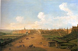 The street as portrayed by Antonio Joli (18th century)
.jpg)
._Casa_de_Alba.jpg)
See also edit
References edit
- Citations
- ^ a b c Jurado Sánchez et al. 1991, p. 223.
- ^ Domingo, Marta R. (14 July 2007). "Carmena reducirá a dos carriles la calle Atocha y peatonalizará Carretas". ABC.
- ^ "Callejero Oficial del Ayuntamiento de Madrid" (PDF). Ayuntamiento de Madrid. 15 May 2017. p. 58.
- ^ Lopezosa Aparicio 2018, p. 200.
- ^ Jurado Sánchez et al. 1991, p. 222; Lopezosa Aparicio 2018, p. 200
- Bibliography
- Jurado Sánchez, José; Marín Perellón, Francisco José; Reyes Leoz, José Luis de los; Río Barredo, María José del (1991). "Espacio urbano y propaganda política: Las ceremonias públicas de la monarquía y Nuestra Señora de Atocha". Madrid en la época moderna: espacio, sociedad y cultura: coloquio celebrado los días 14 y 15 de diciembre de 1989. Madrid: Ediciones de la Universidad Autónoma de Madrid & Casa de Velázquez. pp. 219–264. ISBN 84-7477-314-8.
- Lopezosa Aparicio, Concepción (2018). "Comodidad y orden público en Madrid en el siglo XVIII. El proceso de configuración del límite oriental de la ciudad". Urbana: Revista Eletrônica do Centro Interdisciplinar de Estudos sobre a Cidade. 10 (1). Campinas: Universidade Estadual de Campinas. doi:10.20396/urbana.v10i1.8651822.