Browning is an unincorporated community located in Leflore County, Mississippi. Browning is approximately 2 miles (3.2 km) east of Greenwood and 5 miles (8.0 km) west of Valley Hill on Browning Road near U.S. Route 82.
Browning, Mississippi | |
|---|---|
 | |
 Browning  Browning | |
| Coordinates: 33°31′05″N 90°07′11″W / 33.51806°N 90.11972°W | |
| Country | United States |
| State | Mississippi |
| County | Leflore |
| Elevation | 128 ft (39 m) |
| Time zone | UTC-6 (Central (CST)) |
| • Summer (DST) | UTC-5 (CDT) |
| ZIP code | 38930 |
| Area code | 662 |
| GNIS feature ID | 667634[1] |
It is part of the Greenwood, Mississippi micropolitan area.
History edit
Browning is located on the Columbus and Greenville Railway and was once known as Adlena.[2] A post office operated under the name Adlena from 1898 to 1903 and under the name Browning from 1903 to 1912.[2]
Browning was once home to a vocational school.[3]
Gallery edit
-
 Browning Community Park sign located in the community
 -
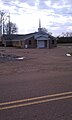 Morning Star M.B. Church located in Browning
 -
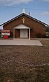 Pleasant Plain M.B. Church located on Browning Road in Browning
 -
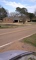
 Browning Well, located on Browning Road in the community
 -
 Home located in the Browning Community
 -
 Home located in the Browning Community


References edit
- ^ U.S. Geological Survey Geographic Names Information System: Browning, Mississippi
- ^ a b Howe, Tony. "Browning, Mississippi". Mississippi Rails. Retrieved February 14, 2023.
- ^ Keenan, Walter E. (1957). Soil Survey, Leflore County, Mississippi. Washington, D.C.: United States Department of Agriculture. p. 43.
This Leflore County, Mississippi state location article is a stub. You can help Wikipedia by expanding it. |