Balassagyarmat (Hungarian: Balassagyarmati járás) is a district in north-western part of Nógrád County. Balassagyarmat is also the name of the town where the district seat is found. The district is located in the Northern Hungary Statistical Region.
Balassagyarmat District
Balassagyarmati járás | |
|---|---|
 Flag  Coat of arms | |
 Balassagyarmat District within Hungary and Nógrád County. | |
| Country | |
| County | Nógrád |
| District seat | Balassagyarmat |
| Area | |
| • Total | 532.94 km2 (205.77 sq mi) |
| • Rank | 2nd in Nógrád |
| Population (2011 census) | |
| • Total | 40,326 |
| • Rank | 2nd in Nógrád |
| • Density | 76/km2 (200/sq mi) |
Geography edit
Balassagyarmat District borders with the Slovakian regions of Nitra and Banská Bystrica to the north, Szécsény District and Pásztó District to the east, Vác District (Pest County) to the south, Rétság District to the southwest, Szob District (Pest County) to the west. The number of the inhabited places in Balassagyarmat District is 29.
Municipalities edit
The district has 1 town and 28 villages. (ordered by population, as of 1 January 2013)[1]
- Balassagyarmat (16,055) – district seat
- Becske (549)
- Bercel (2,088)
- Cserháthaláp (359)
- Cserhátsurány (837)
- Csesztve (327)
- Csitár (404)
- Debercsény (73)
- Dejtár (1,377)
- Drégelypalánk (1,491)
- Érsekvadkert (3,574)
- Galgaguta (645)
- Herencsény (593)
- Hont (475)
- Hugyag (856)
- Iliny (157)
- Ipolyszög (649)
- Ipolyvece (773)
- Magyarnándor (1,122)
- Mohora (942)
- Nógrádkövesd (692)
- Nógrádmarcal (556)
- Őrhalom (983)
- Patak (912)
- Patvarc (708)
- Szanda (662)
- Szécsénke (199)
- Szügy (1,391)
- Terény (380)
The bolded municipality is the city.
Demographics edit
Religion in Balassagyarmat District (2011 census)
In 2011, it had a population of 40,326 and the population density was 76/km2.
| Year | County population[2] | Change |
|---|---|---|
| 2011 | 40,326 | n/a |
Ethnicity edit
Besides the Hungarian majority, the main minorities are the Roma (approx. 2,000), Slovak (400) and German (100).
Total population (2011 census): 40,326
Ethnic groups (2011 census):[3] Identified themselves: 37,603 persons:
- Hungarians: 34,861 (93.70%)
- Gypsies: 1,932 (5.19%)
- Slovaks: 380 (1.02%)
- Others and indefinable: 430 (1.14%)
Approx. 2,500 persons in Balassagyarmat District did not declare their ethnic group at the 2011 census.
Religion edit
Religious adherence in the county according to 2011 census:[4]
- Catholic – 24,829 (Roman Catholic – 24,781; Greek Catholic – 45);
- Evangelical – 2,561;
- Reformed – 681;
- other religions – 610;
- Non-religious – 2,049;
- Atheism – 335;
- Undeclared – 9,261.
Gallery edit
-
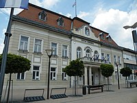 Balassagyarmat, Civitas Fortissima
 -
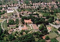 Aerial view of Bercel
 -
-
 Madách Chateau in Csesztve
 -
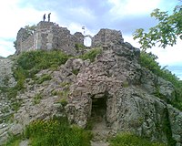
 View of Szanda
 -
 Holy Trinity Church in Patak


.jpg)

_l%C3%A1tk%C3%A9pe_-_h%C3%A1tt%C3%A9rben_a_Szanda_hegy_vonulataival_%C3%A9s_a_Berceli-heggyel.jpg)

See also edit
References edit
- ^ A KSH 2013. évi helységnévkönyve
- ^ népesség.com, "Balassagyarmati járás népessége"
- ^ 4.1.6.1 A népesség nemzetiség szerint, 2011, (in Hungarian) [1]
- ^ 4.1.7.1 A népesség vallás, felekezet szerint, 2011, (in Hungarian) [2]
External links edit
47°59′00″N 19°20′00″E / 47.9833°N 19.3333°E
This Nógrád county location article is a stub. You can help Wikipedia by expanding it. |