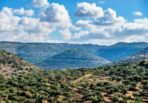
Artabba Fortress is a Hasmonean-Herodian fortress, discovered in 2015 by Dr. Dvir Raviv from Bar-Ilan University and Dr. Aharon Tavger from Ariel University.[1] The site is located at the top of a hill at a height of 364 meters, is near the ravine of Wadi Artabba, also known as Nahal Natuf, southeast of the Palestinian village of Deir Abu Mash'al in the West Bank.
Hebrew: מבצר ארטבה, Arabic: Khirbet Artabba | |
 Aerial view of Artabba fortress | |
 Shown within Israel | |
| Location | Beit El Mountains |
|---|---|
| Region | West Bank |
| Coordinates | 31°59′23″N 35°04′27″E / 31.98972°N 35.07417°E |
| Type | Fortress |
| Area | max 22 dunam |
| Height | 364 |
| History | |
| Founded | 2nd century BCE |
| Periods | Hasmonean period, Herodian period |
| Cultures | Second Temple Judaism |
| Associated with | Jews |
| Site notes | |
| Archaeologists | Dvir Raviv, Aharon Tavger |
| Condition | In ruins |
| Public access | Open year round |
Fortress discovery edit
.jpg)
.jpg)


In 2015, as part of the Israeli South Samaria survey in the West Bank, the remains of a fortified site from the Second Temple period were uncovered on a hill in the west Beit El Mountains.[2] The site, which was unknown until recently, [clarification needed] is located at the top of a cone-shaped hill, about ten kilometers northeast of Modi'in and about a kilometer southeast of the village of Deir Abu Mash'al. The hill is hidden from its distant surroundings and only those who approach it notice it; Perhaps because of this the site "disappeared" from the eyes of researchers who explored the area.[1] The hill (364 meters above sea level) dominates the ravine of Nahal Natuf (Wadi Artabba), that has created steep slopes surround the hill.[3]
On the lower part of the south-western slope, there is another ancient site called Khirbat Artabba and about 200 meters down stream, west of the hill, is the spring of Ein Artabba. The summit of the site is relatively flat, has an area of about 22 dunams and is mostly covered by currently cultivated land.[1]
During a tour of the site in June 2015, it became clear that residents of Deir Abu Mash'al had begun development and construction work on the site with the help of heavy mechanical tools, partly for the purpose of breaking through to access the top of the hill and erecting a structure.[1]
In the course of these works, the remains of a square tower built in the Hellenistic-Hasmonean style were exposed and damaged, the corner was displaced during the work. Architectural items were also uncovered, the openings of five large cisterns, storage pits, as well as types of quarries (building foundations and stone quarries). The residents' earthworks were accompanied by systematic antiquities looting all over the site. These acts brought to the surface many fragments of pottery from the Hellenistic and early Roman periods. The fort that was discovered during earthworks was not known to researchers until its current discovery.
According to the pottery found at the site, it dates to the period between the middle of the second century BC and its abandonment at the end of the first century BC. Estimates accepted by site researchers are that the fort functioned from the time of Hasmonean leaders Jonathan Apphus or Simon Thassi until the end of Herod's reign.[1]
The Hasmonean era edit
The fort was part of the Hasmonean fortresses in southern Samaria guarding the kingdom.[1]
The historical background for the establishment of the fort in the place can be learned from its geographic-historical data. The hill of the fortress dominates the large ravine of Nahal Natuf, which descends from Mount Beit El to the west towards the Shepelah. The wide ravine allowed a relatively convenient passage between the Modi'in area and the center of Mount Beth El and it can be assumed that the Hasmoneans made a lot of use of it during the years of the Maccabean Revolt. In addition to this, it is worth noting a small, isolated, sloped valley with springs, located at the central part of the stream, about 2 km east of Artabba. The unique characteristics of this valley allowed the Hasmonean rebels to use it as a refreshing and organizing base.[4]
From a geographical-historical point of view, the fort is located in the northern part of the region of Ramataim, one of the three regions that were transferred from Samaria to Judea as part of the agreement concluded between Jonathan Apphus and Demetrius II in 145 BCE.[4] The three toparchies, which extend along the northern edge of the Yehud Medinata in its borders from the days of the return to Zion, and it is acceptable to assume that they were inhabited mainly by a Jewish or pro-Jewish population even before they were annexed to Judaea. This citadel can be seen as part of a fortifications system designed to establish control over this area while forming a fortified line controlling the northern area of the Hasmoneans in the second half of the 2nd century BCE.[1]
The findings on the site edit
According to Dr. Raviv's assessment, "Settlement at the site began as an agricultural one in the early Second Temple period on the western slope of the hill, at a site called "Khirbat Artabba", while in the days of Jonathan or Shimon the Hasmoneans, a royal fortress was erected at the top of the hill and later buildings were built on the southern slope of the hill including cisterns and warehouses".[1]
The fortifications edit


The built fortifications[5] were added to the natural fortification of the site. The remains of a perimeter wall were exposed on the northern, eastern and southern sides of the site hill. The most impressive remains were found in the southwest corner of the hill during the preparation of an access road to its top. These remains include two wall sections perpendicular to each other, which form a corner of the perimeter wall or of a square tower. These walls have been preserved to a height of 5 courses and were built of large hewn stones with chiseled edges and a coarse ledge, which were laid using the head and patina method, except for the lower course, where the stones were placed using the head and stringer method.[1]
This construction method is typical of the Hellenistic period in the Land of Israel and is known from the fortifications of the first wall from the Hasmonean era in Jerusalem and from other sites, such as the round towers in Samaria, the fortifications of Alexandrium[6] and Aroma in Samaria. A similar construction style is also found in other sections of the perimeter wall and makes it possible to date the remains of the fortifications in place to the Hasmonean period. The location of the walls sections standing at point overlooking the southern slope of the hill, is probably where the access road to the site was installed. This allows us to suggest that before us are the remains of a tower that guarded the entrance gate to the fort.
Purification Mikvehs edit

In the northern part of the site, two mikvehs were recorded.[1] One mikveh was incorporated in a later period into a cistern. This mikveh includes a stepped entrance and an opening approximately 1.5 meters high and 1 meter wide. The opening leads to a square baptismal chamber measuring 3.5x3.5 meters and five carved steps descend to its bottom. The sides and steps of the mikveh are coated with a thick layer of white plaster and on top of that a layer of gray plaster like the plaster seen in the water pits (below). The integration of the mikveh space into the cistern was done with the sealing of its original entrance. The ancient plaster layer in the mikveh was probably installed during the Hasmonean period.[1]
The second mikveh includes a carved entrance, a 1.5-meter-high arched opening leading to a square baptismal chamber that measures 3.2x3.3 meters, and on its sides traces of light gray plaster are visible. Therefore, it seems to have been carved during the Herodian period. The bottom of the mikveh is covered in silt, but it can be seen at least on one step. In the period after finding the mikvehs, acts of robbery were carried out in them damaging the stairs and the floor.[7]
The cisterns edit


The most impressive remains on the site are five large rock-cut water cisterns.[8] Two cisterns are located to the south of the hill and three in the northern part, all within the fortified area. The soft chalk rock made it possible to carve the cisterns relatively easily, but also required consideration of the possibility of disintegration and collapse. The fear of the ceiling collapsing led to digging long, narrow cisterns and even building a retaining wall in one of them.[9]
The shape of the cisterns are usually square: Cistern No. 1 is rectangular, Cistern 2&4 are trapezoidal, Cistern No. 3 is cross-shaped, and Cistern 5 is square. The dimensions of the cistern on average: 16 meters long, 7 meters wide, 6 meters high and a volume of about 600 cubic meters. Cistern 4 is the largest of the Cisterns: it is 22 meters long, 10 meters wide, 11 meters high and could store more than 1,200 MK. The data is only partial, as today the pits are filled with a lot of silt covering their bottoms. In all the cisterns there is at least one opening in the ceiling and in four of them there are also other openings in one of the sides. The openings in the roof of the cisterns are relatively small and were used for pumping and absorbing water.[7]
In contrast, the side openings are generally wide and seem to have been used for the entrance of the workers. When the quarrying ended, the side openings were closed with smooth stone walls. The sides of the cisterns and their bottoms are covered with two layers of plaster: a thick layer of white plaster typical of the Hellenistic period and above it a layer of gray plaster typical of the early Roman period. Horizontal lines remain on top of the plaster, some of them very high, which indicate the levels of water storage and the large amount that was actually stored in the cisterns. The area of the dome and the location of the site in a relatively rainy area made it possible to easily collect the runoff water and fill the cisterns. The location of the water cisterns in the center of the fortress hill and not at the edge allowed easy and safe access to them during a siege.[7]
The water cisterns at Artabba are similar in shape and size to the water reservoirs, usually based on the collection of surface runoff water, found in fortresses and citadels within the Hasmonean state, including in the fortresses of the Judean desert such as Alexandrium, Kyprus and Hyrcania, which clearly date to the Hasmonean period. The total volume of the cisterns in Artabba is estimated at more than 3,400 cubic meters, a considerable amount of water compared to the other forts, which was collected through canals and moats and was intended to allow standing a prolonged siege and supply water to the site's inhabitants, and perhaps even to the area residents in times of need.
The common typology of the waterworks in the royal citadels, the similar shape of some of the cisterns as well as the white plaster, make it possible to date the digging of the cisterns on the site to the Hasmonean period and their continued use to the Herod days. However, due to the unusual shape of Pit No. 3 and its impact on an ancient facility (Mikveh described above), it may have been dug only during Herod's time.[1]
Warehouses edit
On the northern slope of the site hill, a large cave was found that was apparently used for storage and contains many pottery fragments from the Hellenistic period. At the bottom of the southern and eastern slopes of the hill are scattered the remains of buildings built mostly of field stones and polished stones. Besides them, cisterns, a lime kiln, quarries, burial caves and storage caves were located.[1]
Worthy of mentioning is a large cave roofed with carved arches, in which many fragments of pottery were found, most of them jugs, which are common in assemblages dating from the period between the revolts[clarification needed] and the days of the Bar Kokhba revolt. According to the shape of the cave it seems that it was carved in the Herodian period and was used as a royal storehouse.[1]
The site's history in light of the findings edit
The geographical and archaeological data of the Artabba fortress show that it was one of the fortresses of Judah during the Second Temple period. Its location at the top of a lofty hill, the remains of the fortifications and the impressive water supply system are the main characteristics of the Judean Desert fortresses and of the fortresses that were built in the settled parts of the Hasmonean-Rhodian kingdom. Dozens of pottery fragments found at the site make it possible to date the construction of the fort to the middle of the 2nd century BC and its existence until the end of the 1st century BC, that is, from the days of Jonathan Apphus or Simon Thassi to the end of Herod's time. This is while the settlement that was located at the foot of the fortress hill, to the south and southwest of it (Khirbat Artabba), continued to exist until the days of the Bar Kokhba revolt.
Districts transferred of from Samaria to Judea edit
From a geographical-historical point of view, the Artabba fortress is located in the northern part of the Ramataim district, one of the three districts that were transferred from Samaria to Judea as part of the agreement between Jonathan Apphus (161-142 BC) and Demetrius II in 145 BC (Maccabim 11:34).[1] The three districts extend on the northern edge of the Judean Basin at its borders during the days of return to Zion, and many researchers saw their annexation as a ratification of an existing situation, in which Jews lived in this area already at the beginning of the Hasmonean period.[7] This agreement led to the acceleration and development of the Jewish settlement in southern Samaria, and from now on the northern border of the Hasmonean kingdom passed through the northern border of the three districts. The location of the Artabba fortress near this border allows it to be seen as a northern border fortress of Judah at the beginning of the Hasmonean state. In light of these data, it can be assumed that the Artabba fortress was built by Simon Thassi.
The geographical data of the Artabba fortress, and especially its location near the northern border of Judah during the Second Temple period and its proximity to district capitals (Ramataim and Timanah), allowed it to fulfill both security and administrative functions.[1] At the end of the first century BC, the fort passed into the hands of Herod, like the other forts of the Hasmonean kingdom. The remains from this period show the continued use of the cisterns and the construction of a monumental building in the place from which a stone survived that was part of a cornice that decorated the front of a magnificent building. The Herodian royal building in Artabba is part to the other royal estates from the period of House of Herod recorded in the southwestern region of Samaria. It seems that the fort was abandoned at the end of Herod's time and no longer stands.
Artabba ruins edit
The ruins lie at the foot of the fort, on the southwestern slope of the hill. It was first described in the PEF Survey of Palestine and then in the Israel Antiquities Authority archive division and in the surveys of Israel Finkelstein, Zvika Tzuk and Dr. Raviv Dvir.[1]
The size of the ruin is about 20 dunams and parts of its stones can be seen in secondary use on nearby terraces. Water cisterns and burial caves and remains of a weaving house were found on the site and in its vicinity. Over 90% of the ceramics collected at the site have been dated to the Hellenistic-Roman periods.
Photo Gallery edit
-
 A section of a wall from a Hasmonean tower integrated into the fortress wall
 -
 View from the Hasmonean fortress eastward towards the Zerka springs reserve
 -
 Researchers and documenters recording ancient remains in one of the water pits
 -
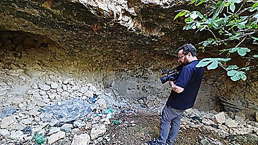 Trash left by antiquities thieves at the site
 -
 Ashlar stones from the Hasmonean wall
 -
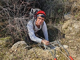 Preparations for descending into the reservoir
 -
 View from inside the reservoir
 -
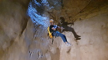 Sliding into the reservoir
 -
 The team inside the reservoir


References edit
- ^ a b c d e f g h i j k l m n o p q Raviv, Dvir (2018). "The Artabba Fortress: An Unknown Hasmonaean-Herodian Fortress on the Northern Border of Judaea". Israel Exploration Journal. 68 (1): 56–76. ISSN 0021-2059. JSTOR 26740637.
- ^ קמר, אסף (2019-12-27). "מבצר החשמונאים הסודי: ביקור באתר העתיק שהתגלה במקרה". Ynet (in Hebrew). Retrieved 2024-03-27.
- ^ Marom, Roy (2022). "The Cave of the Patriarchs (al-Haram al-Ibrahimi) in Muslim Tradition". In the Highland's Depth. 12: 55–81. doi:10.26351/ihd/12/3. ISSN 2521-9456.
- ^ a b 1 Maccabees 11:34
- ^ קמר, אסף (2020-12-16). "ביקור ראשון בבור החשמונאי: מסע במנהרת הזמן לאתר בן אלפיים שנה". Ynet (in Hebrew). Retrieved 2024-03-27.
- ^ Richardson, Peter; Marie Fisher, Amy (2018). Herod: King of the Jews and Friend of the Romans (2 ed.). Routledge. p. 392. ISBN 978-1-1388-0392-3. Retrieved 21 June 2018.
- ^ a b c d Raviv, Dvir; Tavger, Aharon (2021). "מבצר ארטבה (נ.ג.364) חשיפתו של מבצר חשמונאי-הרודיאני בגבולה הצפוני של יהודה" (PDF). במעבה ההר. 11 (1): p: 73-97.
- ^ Raviv, Dvir. "Raviv D., 2018, "The Artabba Fortress: An Unknown Hasmonean-Herodian Fortress on the Northern Border of Judaea", IEJ 68 (1), pp. 56-76".
{{cite journal}}: Cite journal requires|journal=(help) - ^ קמר, אסף (2020-12-16). "ביקור ראשון בבור החשמונאי: מסע במנהרת הזמן לאתר בן אלפיים שנה". Ynet (in Hebrew). Retrieved 2024-04-09.