Roda Island (or Rawdah Island, Arabic: جزيرة الروضة, Jazīrat ar-Rawdah [ɡɪˈziːɾɪt eɾˈɾoːdɑ]) is an island neighbourhood in the Nile in central Cairo, alternatively or partially known as Manial al-Roda, or al-Manial,[1] in reference to the main village that existed on the island before it was urbanised,[2] and is part of the Misr al-Qadima district.
Native name: جزيرة الروضة | |
|---|---|
 Nile branch between Roda Island and Old Cairo | |
 OpenStreetMap rendering of Roda Island | |
| Geography | |
| Location | Nile River, Cairo |
| Coordinates | 30°01′15″N 31°13′32″E / 30.02083°N 31.22556°E |
| Administration | |
History
editThe island was known in Antiquity as Babylonian Island (Ancient Greek: Νῆσος Βαβυλῶνος), referring to the Babylon Fortress.[3]
During the reign of caliph Sulaymān ibn ʿAbd al-Malik of the Umayyad dynasty, a nilometer was built on the southern tip of the island opposite the mouth of the Khalij canal in AD 715 to measure the annual Nile flood.[4][5] The structure was replaced in AD 861, during the reign of the Abbasid caliph al-Mutawakkil,[6] overseen by the astronomer Alfraganus, and despite a number of modifications, is still extant today and known as the Roda Island Nilometer.[7]
The Ayyubid Sultan as-Salih Ayyub (Reigned 1240 to 1249, great-nephew of Saladin) built a palace at the southern tip of the island near the nilometer.[8][9]
The mamluk Bahri dynasty originally settled on Roda Island at the palace.[9] The name of the dynasty, "Bahriyya", means 'of the river', referring to their original settlement on the island on the Nile.
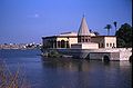
The Bostan al-Kebir (Great Gardens) started to be planned and grown on the island in 1829 by Viceroy Ibrahim Pasha, of the Muhammad Ali Dynasty.[10] In 1851 the Manasterly Palace, also known as the Kiosk was built on the island's southern tip on the ruins of the Ayyubid palace for Hassan Fouad Pasha Al-Manasterly, Katkhoda of Egypt during the reign of Abbas I.[8] Later in the early 20th Century the Prince Muhammad Ali Palace was built in the island's mid-north.[11]
Today, the island is a bustling neighbourhood of Cairo.[1]
Gallery
edit-
 Northern tip
 -
 c.1800 map of Roda Island
 -
 Wooden bridge near the Nilometer
 -
 The Roda Island Nilometer, and island in the Nile
 -


References
edit- ^ a b "Manial Al-Roda: Birdsong and the call to prayer - Features - Al-Ahram Weekly". Ahram Online. Retrieved 2023-02-19.
- ^ Egyptian Survey Department (1915). "Map of Cairo". Al-Madaq. Retrieved 2023-02-19.
- ^ Maspero, Jean; Wiet, Gaston (1919). "Materiaux pour servir à la Géographie de l'Égypte". Journal of the Royal Asiatic Society. 53 (4): 68.
- ^ Brian Fagan (1 August 2010). The Great Warming: Climate Change and the Rise and Fall of Civilizations. Bloomsbury Publishing. p. 167. ISBN 978-1-59691-780-4.
- ^ Ibn ʿAsākir. Tārīkh Madīnat Dimashq. pp. 8:84.
- ^ Doris Behrens-Abouseif (1992). Islamic Architecture in Cairo: An Introduction. BRILL. p. 51. ISBN 90-04-09626-4.
- ^ "Rawda Island Nilometer". egymonuments.gov.eg. Retrieved 2023-02-19.
- ^ a b "A Virtual Tour through Al-Manasterly palace and the Nilometer". egymonuments.gov.eg. Retrieved 2023-02-19.
- ^ a b Al-Maqrizi, p.405/vol. 1
- ^ Rafaat, Samir (1997-11-27). "Prince Mohammed Ali Tewfik Manial Retreat". www.egy.com. Retrieved 2023-02-19.
- ^ "Manial Palace Museum". egymonuments.gov.eg. Retrieved 2023-02-19.
External links
edit![]() Media related to Rhoda Island at Wikimedia Commons
Media related to Rhoda Island at Wikimedia Commons
- The Al-Manyal Palace Museum and gardens
- (in German) Wikivoyage.org: Rōḍa - on Wikivoyage.org
This geography of Egypt article is a stub. You can help Wikipedia by expanding it. |